Tags
Anderson Hatfield, Appalachia, Ephraim Hatfield, Evermont Ward, genealogy, history, James Lawson, John Allen, Logan County, Mates Creek, Mingo County, Valentine Hatfield, Virginia, West Virginia, William A. Dempsey

11 Tuesday May 2021
Posted in Big Sandy Valley, Matewan
Tags
Anderson Hatfield, Appalachia, Ephraim Hatfield, Evermont Ward, genealogy, history, James Lawson, John Allen, Logan County, Mates Creek, Mingo County, Valentine Hatfield, Virginia, West Virginia, William A. Dempsey
16 Tuesday Feb 2021
Posted in Big Sandy Valley, Hatfield-McCoy Feud, Matewan
Tags
Appalachia, Double Camp Branch, Ellison Hatfield, Ephraim Hatfield, genealogy, H.R. Phillips, Hatfield-McCoy Feud, history, Logan County, Magnolia District, Mates Creek, Mingo County, West Virginia
The following land information is derived from Land Book 1880-1886, Land Book 1887-1892, and Land Book 1893-1899 at the Logan County Clerk’s Office in Logan, WV:
Ellison Hatfield
No property listed in 1865-1879.
1880: Magnolia District
50 acres Double Camp Fork, Ben Creek $0.25 per acre no building $12.50
300 acres Mates Creek $0.25 per acre no building $75 total
[Note: The 300-acre tract was transferred from Ephraim Hatfield.]
1881: Magnolia District
50 acres Double Camp Fork Mates Creek $0.25 per acre no building $12 total
276 acres Mates Creek $0.25 per acre no building $69 total
[Note: The reduction of the 300-acre tract is unexplained.]
1882: Magnolia District
The Hatfield page is missing.
1883: Magnolia District
No records are listed for this year.
1884: Magnolia District
50 acres Double Camp Br. Mates Creek $2.50 per acre $25 building $125 total
276 acres Double Camp Br. Mates Creek $1 per acre no building $276 total
20 acres Double Camp Mates Creek $1 per acre no building $20 total
[Note: The 50-acre and 276-acre tract is listed in the name of “Ellison Hatfield’s Heirs”. The 20-acre tract is listed in the name of Ellison Hatfield.]
1885: Magnolia District
50 acres Double Camp Branch, Mates Creek $2.50 per acre $25 building $125 total
276 acres Double Camp Branch, Mates Creek $1 per acre no building $276 total
50 acres Double Camp Branch, Mates Creek $2.50 per acre $30 building $125 total
1886: Magnolia District
50 acres Mates Creek $2.50 per acre no building $56 total
20 acres Mates Creek $1 per acre no building $130 total
1887-1889: Magnolia District
Ellison Hatfield
50 acres Mates Creek $2.50 per acre $30 building $125 total
20 acres Mates Creek $1 per acre no building $20 total
Ellison Hatfield’s Heirs
50 acres Double Camp, Mates Creek $2.50 per acre $25 building $125 total
276 acres Double Camp, Mates Creek $1 per acre no building $276 total
20 acres Double Camp, Mates Creek $1 per acre no building $20 total
[Note: In 1887, the latter three tracts are noted as “one yr back tax & interest.” In 1888, the latter three tracts are noted as “sold to Okeefe for tax.” In 1889, the latter three tracts are restored to Ellison Hatfield’s heirs.]
1890-1891: Magnolia District
Ellison Hatfield
50 acres Mates Creek $2.50 per acre $30 building $125 total
20 acres Mates Creek $1 per acre no building $20 total
Ellison Hatfield’s Heirs
50 acres Double Camp, Mates Creek $2.50 per acre $25 building $125 total
276 acres Double Camp, Mates Creek $1 per acre no building $276 total
28 acres Double Camp, Mates Creek $1 per acre no building $28 total
1892: Magnolia District
Ellison Hatfield
50 acres Mates Creek $2.50 per acre $25 building $125 total
20 acres Mates Creek $2 per acre $40 building $175 total
Ellison Hatfield’s Heirs
50 acres Double Camp, Mates Creek $3.50 per acre $30 building $175 total
276 acres Double Camp, Mates Creek $3.50 per acre no building $966 total
28 acres Double Camp, Mates Creek $3.50 per acre no building $98 total
1893: Magnolia District
Ellison Hatfield
50 acres Mates Creek $2.50 per acre $30 building $125 total
20 acres Mates Creek $2 per acre no building $40 total
[In 1893, Ellison Hatfield’s heirs by commissioner transferred 250 acres on Mates Creek worth $3.50 per acre and total value of $875 to H.R. Phillips, trustee.]
15 Monday Feb 2021
Posted in Big Sandy Valley, Hatfield-McCoy Feud, Matewan
Tags
Appalachia, Ephraim Hatfield, genealogy, Hatfield-McCoy Feud, history, Logan County, Magnolia District, Marks Branch, Mates Creek, Mingo County, Nancy Hatfield, Patterson Hatfield, Smith Hatfield, West Virginia
The following land information is derived from Land Book 1873-1874, Land Book 1880-1886, and Land Book 1893-1899 at the Logan County Clerk’s Office in Logan, WV:
Smith and Patterson Hatfield
No property listed in 1865-1877.
1878: Magnolia District
Smith and Patterson Hatfield
100 acres Mates Creek $4 per acre $25 building $400 total
[Note: This tract was transferred from Ephraim Hatfield in 1878.]
Smith Hatfield
25 acres Marks Branch, Mates Creek $0.20 per acre no building $5 total
1879: Magnolia District
No records for this year.
1880-1881: Magnolia District
Smith and Patterson Hatfield
100 acres Mates Creek $4 per acre $25 building $400 total
Smith Hatfield
25 acres Marks Branch, Mates Creek $0.20 per acre no building $5 total
[Note: In the 1880 census, widowed Nancy Hatfield lived with her son, Patterson.]
1882: Magnolia District
The Hatfield page is missing.
1883: Magnolia District
The page is mostly blank but does list:
Smith Hatfield 25 acres M__ Br of Mates Creek $2.50 per acre [rest is blank]
1884-1885: Magnolia District
Smith and Patterson Hatfield
100 acres Mates Creek $3 per acre $35 building $300 total
Smith Hatfield
25 acres Marks Br. of Mates Creek $2.50 per acre no building $62.50 total
1886: Magnolia District
Smith and Patterson Hatfield
100 acres Mates Creek $3 per acre no building $230 total
Smith Hatfield
25 acres Mack Branch, Mates Creek $2.50 per acre [blank]
1887-1888: Magnolia District
Smith and Patterson Hatfield
100 acres Mates Creek $3 per acre $35 building $300 total
Smith Hatfield
25 acres Marks Branch, Mates Creek $2.50 per acre no building $62.50 total
1889: Magnolia District
Smith Hatfield
25 acres Mark Branch, Mate Creek $2.50 per acre no building $65 total
Pat Hatfield
50 acres Mates Creek $3 per acre $35 building $150 total
1890: Magnolia District
Smith Hatfield
25 acres Mate Creek $2.50 per acre no building $65 total
50 acres Mate Creek $3 per acre $35 building $150 total
Patterson Hatfield
50 acres Mate Creek $3 per acre $30 building $150 total
1891-1892: Magnolia District
Smith Hatfield
25 acres Mate Creek $2.50 per acre no building $62.50 total
50 acres Mate Creek $3 per acre $35 building $150 total
Patterson Hatfield
50 acres Mate Creek $3 per acre $30 building $150 total
1893-1894: Magnolia District
Smith Hatfield
25 acres Mate Creek $2.50 per acre no building $62.50 total
50 acres Mate Creek $3 per acre $40 building $150 total
Patterson Hatfield
50 acres Mate Creek $2.50 per acre $40 building $125 total
12 Friday Feb 2021
Posted in Big Sandy Valley, Guyandotte River, Hatfield-McCoy Feud, Logan, Matewan
Tags
Appalachia, Big Island, Big Sandy River, E.K. Counts, Elias Hatfield, genealogy, George W. Duty, Hardee District, Hatfield-McCoy Feud, history, Logan County, Logan County Banner, Logan District, Magnolia District, Magnolia Township, Mates Creek, Mingo County, Oliver Perry, Warren Alderson, West Virginia
The following land information is derived from Land Book 1866-1872, Land Book 1873-1874, Land Book 1880-1886, Land Book 1887-1892 , and Land Book 1893-1899 at the Logan County Clerk’s Office in Logan, WV:
Elias Hatfield
No property listed in 1865-1868.
1869-1870: Magnolia Township
100 acres Mates Creek $4.00 per acre no building $400 total from E.K. Counts
30 acres Mates Creek $10 per acre no building $300 total from E.K. Counts
50 acres Mates Creek $20 per acre no building $1000 total from E.K. Counts
1871: Magnolia Township
100 acres Mates Creek $3.00 per acre $50 building $300 total
30 acres Mates Creek $3.00 per acre no building $90 total
50 acres Mates Creek $3.00 per acre no building $150 total
1872: Magnolia Township
100 acres Mates Creek $3.00 per acre $50 building $300 total
30 acres Mates Creek $3.00 per acre no building $90 total
50 acres Mates Creek $3.00 per acre no building $150 total
50 acres Mates Creek $3.00 per acre no building $150 total
350 acres Mates Creek $0.25 per acre no building $87.50 total from W. Alderson (assessor)
1873: Magnolia District
100 acres Mates Creek $3.00 per acre no building $300 total
30 acres Mates Creek $3.00 per acre no building $40 total
50 acres Mates Creek $3 per acre no building $150 total
400 acres Two Tracts Mates Creek $1 per acre no building $400 total
50 acres Mates Creek $3 per acre no building $150 total
350 acres Mates Creek $0.25 per acre no building $87.50 total
1874: Magnolia District
100 acres Mates Creek $3.00 per acre $50 building $300 total
50 acres Mates Creek $3 per acre no building $150 total
30 acres Mates Creek $3.00 per acre no building $40 total
400 acres Two Tracts Mates Creek $1 per acre no building $400 total
50 acres Mates Creek $3 per acre no building $150 total
350 acres Mates Creek $0.25 per acre no building $87.50 total
1875-1876: Magnolia District
100 acres Mates Creek $3.00 per acre $50 building $300 total
50 acres Mates Creek $3 per acre no building $150 total
30 acres Mates Creek $3.00 per acre no building $40 total
400 acres Two Tracts Mates Creek $1 per acre no building $400 total
50 acres Mates Creek $3 per acre no building $150 total
[Note: In 1875, Elias transferred his 350-acre tract but records do not identify the recipient.]
1877: Magnolia District
Records are blank for this district.
1878: Magnolia District
100 acres Mates Creek $3 per acre $50 building $300 total
30 acres Mates Creek $3 per acre $90 building $90 total
400 acres 2 Tracts, Mates Creek $0.25 per acre no building $100 total
50 acres Mates Creek $2 per acre no building $100 total
[Note: Records for this year spelled his name as Allias Hatfield.]
1879: Magnolia District
Records are missing for this year
1880: Magnolia District
100 acres Mates Creek $3 per acre $50 building $300 total
30 acres Mates Creek $3 per acre $90 building $90 total
400 acres 2 Tracts, Mates Creek $0.25 per acre no building $100 total
50 acres Mates Creek $2 per acre no building $100 total
1881: Magnolia District
100 acres Mates Creek $3 per acre no building $300 total
30 acres Mates Creek $3 per acre no building $90 total
400 acres 2 Tracts, Mates Creek $0.25 per acre no building $100 total
50 acres Mates Creek $2 per acre no building $100 total
[Note: The 100-acre tract was noted with this: “yrs from G.W. Duty.” The 30 acre tract was noted as “change to Hardee Dist on Book 1882.”]
1882: Magnolia District
The Hatfield page is missing.
1883: Magnolia District
The record is blank for this district
1884: Magnolia District
100 acres Mates Creek $3 per acre $50 building $300 total
30 acres Mates Creek $4 per acre $30 building $120 total
400 acres 2 Tracts, Mates Creek $1 per acre no building $400 total
50 acres Mates Creek $3 per acre no building $150 total
1885: Magnolia District
100 acres Mates Creek $3 per acre $50 building $300 total
30 acres Mates Creek $4 per acre $30 building $120 total
400 acres 2 Tracts, Mates Creek $1 per acre no building $400 total
50 acres Mates Creek $3 per acre no building $150 total
749 acres Mates Creek $1 per acre no building $749
322 acres Mates Creek $1 per acre no building $322 total
[In 1885, he acquired the 749-acre tract from a commissioner. No indication is given about the source of the 322 acres.]
1886: Magnolia District
100 acres Mates Creek $3 per acre [blank]
30 acres Mates Creek $4 per acre [blank]
50 acres Mates Creek $3 per acre [blank]
1471 acres 4 Tracts Mates Creek $1 per acre [blank]
600 acres Sandy River $1.90 per acre no building $56 total
1887: Magnolia District
100 acres Mates Creek $3 per acre $50 building $300 total
30 acres Mates Creek $4 per acre $30 building $120 total
50 acres Mates Creek $3 per acre no building $150 total
1471 acres 4 Tracts, Mates Creek $1 per acre no building $1471 total
600 acres Sandy River $1.90 per acre $40 building $1140 total
1888: Magnolia District
600 acres Sandy River $1.90 per acre $40 building $1140 total
1889-1891: Magnolia District
600 acres Sandy River $1.90 per acre $40 building $1140 total
1889-1891: Logan District
30 acres Big Island $20 per acre no building $600 total
13 acres Big Island and Washed Part $1 per acre no building $13 total
[Note: The 30-acre tract was acquired from Oliver Perry. No indication of the source for the 13 acres. According to the 21 March 1889 issue of the Logan County Banner: “On the 18th inst., Elias Hatfield, purchased of Oliver Perry, the property known as the ‘Big Island’ near this place.”]
1892-1894: Magnolia District
400 acres Sandy River $5 per acre $50 building $2000 total
1892-1894: Logan District
25 acres Big Island Guyandotte River $20 per acre no building $500 total
18 acres Big Island Guyandotte River $1 per acre no building $18 total
12 Friday Feb 2021
Posted in Big Sandy Valley, Hatfield-McCoy Feud, Matewan
Tags
A.E. Steel, Anna Hatfield, Appalachia, Beech Creek, Big Sandy River, Charles R. Mounts, Conley Bottom, Conleys Creek, Daniel Christian, Dempsey Branch, Devil Anse Hatfield, Double Camp, Double Camp Branch, E.S. Murphy, Ephraim Hatfield, Floyd Hatfield, genealogy, George Hatfield, Grapevine Creek, Harrison Steel, history, Island Creek, J.D. Sergeant, Jacob Francesco, James A. Nighbert, James Ferrell, James Mounts, John Green, Johnson Hatfield, justice of the peace, L.D. Steel, Levicy Hatfield, Lewis Steel, Lick Fork, Little Kanawha Lumber Company, Logan County, Logan District, logging, Magnolia District, Magnolia Township, Mash Field, Mate Creek, Mates Creek, Meadow Branch, Mill Seat Fork, miller, Mingo County, Moses Christian, Nancy Hatfield, Philadelphia, Pigeon Creek, Plyant Mayhorn, Polly Hatfield, Preacher Anse Hatfield, Road Fork, Samuel Mayhorn, splash dams, splashing, Stuart Wood, Thacker Creek, timbering, Tug Fork, Tug River, Valentine Wall Hatfield, West Virginia, William Tiller, Wolf Pen Fork
The following land information is derived from Land Book 1866-1872, Land Book 1873-1874, Land Book 1880-1886, Land Book 1887-1892, and Land Book 1893-1899, as well as various deed books, at the Logan County Clerk’s Office in Logan, WV:
Anderson Hatfield
[Property listed in name of Levecy Hatfield in 1869, Levica Hatfield in 1870-1871, Levisa Hatfield in 1872, 1874, and 1876, Levitna Hatfield in 1873, Lavisa Hatfield in 1875, Levica Hatfield in 1889, Lovicy Hatfield in 1890-1891, Lovica Hatfield in 1892, and Levicy Hatfield in 1893.]
No property listed in land books for 1865-1867.
On October 19, 1867, George* and Nancy Hatfield of Pike County, KY, deeded 100 acres on Mate Creek to Levicy Hatfield of Logan County, WV, for five hundred dollars. The property began in the upper end of Mash Field and extended to the mouth of Meadow Branch. Witnessed by JP William Tiller on October 19, 1867.
No property listed in the land book for 1868.
1869: Magnolia Township
100 acres Mates Creek $4.20 per acre no building $420 total
55 acres Mates Creek $2.10 per acre $75 building $136.50 total
[Note: Based on the land book, both tracts were acquired in 1869 from George Hatfield of Kentucky. Also, the 55-acre total value figure did not include the value of the building. Note the actual date of purchase for one of the tracts was 1867, as per the deed.]
1870: Magnolia Township
100 acres Mates Creek $4.20 per acre no building $420 total
55 acres Mates Creek $2.10 per acre no building $136.50 total
1871-1872: Magnolia Township
100 acres Mates Creek $4.20 per acre no building $420 total
55 acres Mates Creek $2.10 per acre no building $115.50 total
[Note discrepancy in the valuation for the 55-acre tract.]
1873: Magnolia District
100 acres Mates Creek $5.25 per acre no building $441 total
55 acres Mates Creek $4.20 per acre no building $420 total
1874: Magnolia District
100 acres Mates Creek $4.20 per acre no building $420 total
55 acres Mates Creek $2.10 per acre $115.50 total
On December 29, 1874, Anderson and Lovicy Hatfield sold 200 acres to Polly Hatfield (all of Logan County) for $780 on Mates Creek. Began at the foot of the north hill at the upper end of the old Mash Field, a conditional corner between Ephraim Hatfield and Anderson Hatfield to the mouth of Meadow Branch to include all the land that George Hatfield had deeded to Lovicy Hatfield. Anderson and Lovicy signed the deed using an “x.” Justice of the peace Valentine Hatfield witnessed the deed on December 29, 1874.
[Note the original 100 acres from the 1867 deed has now become 200 acres.]
1875: Magnolia District
100 acres Mates Creek $4 per acre $50 building $400 total
55 acres Mates Creek $0.25 per acre no building $13.75 total
1876: Magnolia District
100 acres Mates Creek $4 per acre no building $400 total
55 acres Mates Creek $0.25 per acre no building $13.75
[Note: In 1876, according to the land book, Anderson Hatfield transferred 200 acres on Mates Creek worth $0.25 per acre and with a total worth of fifty dollars to Polly Hatfield; the deed is dated 1874 (see above); the 1878 land record corrected the acreage to 55 acres by order of P.A. Counts]
1877: Magnolia District
No records available for this year.
On July 2, 1877, Anderson and Lovicy Hatfield deeded 150 acres at Double Camp and Road forks of Mates Creek for $75 to Floyd Hatfield (all of Logan County). Began at the back line of the John Green survey below Double Camp, then up the main ridge to the top of the point above Road Fork, thence to John Green survey line. Anderson and Lovicy signed the deed using an “x.” Justice of the Peace Valentine Hatfield witnessed the deed on July 2, 1877.
On December 24, 1877, Anderson and Levisa Hatfield deeded 1500 acres on Grapevine Creek to James Vance, Jr. (all of Logan County) for $1400. Began near the mouth of Wolf Pen Fork, thence to the top of the mountain between Grapevine and the river, thence with mountain to dividing ridge between Grapevine and Beech Creek, thence to head of Thacker Creek, thence down ridge between Thacker and Mates Creek… References the ridge between the Wolf Pen and Mill Seat Fork. Anderson and Levicy signed the deed using an “x.” Justice Valentine Hatfield witnessed the deed on December 24, 1877.
1878: Magnolia District
Anse Hatfield owned no property in 1878.
[In 1878, as per the land book, Anderson Hatfield transferred 150 acres on Double Camp and Road Fork of Mate to Floyd Hatfield worth twenty cents per acre and with a total worth of $20. Records showed this as “transferred from Anderson Hatfield.” Note: The deed (above) shows the transfer as 1877.]
1879: Magnolia District
No records exist for this year.
1880-1881: Magnolia District
As per land book, Anse Hatfield owned no land.
On December 9, 1880, Anderson Hatfield, Lovicy Hatfield, Elias Hatfield, and Henry Mitchell deeded 200 acres on Wolf Pen Fork of Grapevine Creek to Robert Cox (all of Logan County) for $200. Anderson Hatfield, Lovicy Hatfield, Elias Hatfield, and Henry Mitchell signed the deed. Justice of the peace Valentine Hatfield witnessed the deed on December 10, 1880.
1882: Magnolia District
The Hatfield page is missing from the land book.
On January 28, 1882, Anderson and Vicy Hatfield deeded 200 acres at Lick Fork of Grapevine Creek to Johnson Hatfield (all of Logan County) for $250. Began at a large rock near the creek bank just above the garden field at the mouth of Lick Fork, thence running out to the center of the point above Lick Fork…to the head of Lick Fork and down the top of the ridge between Grapevine and Thacker Creek… Anderson and Vicy Hatfield signed the deed. Justice Valentine Hatfield witnessed the deed on January 28, 1882.
1883: Magnolia District
Records for this district are blank.
1884: Magnolia District
37 acres Tug River $1 per acre no building $37 total
2900 acres Grape Vine, Tug River $1.25 per acre $50 building $3625 total
[Note: In 1884, Anse transferred 100 acres to Daniel Christian on Grape Vine and Sandy River worth $1.25 per acre with no building and valued at $125. In 1884, Anse transferred 150 acres on Beech Creek and Sandy River to Jacob Francesco worth $1 per acre with no buildings and total value at $150. This latter tract states “by A. Hatfield by P. Mayhorn” and adds that “books don’t show A. Hatfield is owner.” Anse is not named in the 1884 deed to Jacob Francesco.]
1885: Magnolia District
37 acres Tug River $1 per acre no building $37 total
2750 acres Grapevine Creek and Tug River $1.25 per acre $50 building $3437.50 total
[In 1885, he transferred 50 acres on Sandy River to Moses Christian worth $1.25 per acre with a total worth of $62.50. In 1885, he transferred 100 acres on Grapevine Creek to Samuel Mayhorn worth $1.25 per acre with a total worth of $125.]
1886: Magnolia District
No property listed for him in 1886.
[In 1886, he transferred 500 acres on Pigeon Creek to James Ferrell worth $1.12 per acre with a total worth of $500. This note referenced him as “A. Hatfield Sr.” In 1886, he transferred 25 acres on Tug River to E.S. Murphy worth $1 per acre and a total worth of $25. In 1886, he transferred 340 acres on Beech Creek to Harrison Steel valued at $2.25 per acre and with a total worth of $765. This latter note stated: “2 years back tax and with interest; transferred from Ans Hatfield.”]
1887: Magnolia District
37 acres Tug River $1 per acre no building $37 total
2360 acres Grape Vine $1.25 per acre $50 building $2950 total
[Note: For both entries, the record reads: “one yr bk tax & interest.” In 1887, he transferred 69 acres on Sandy River worth $1 per acre and total worth of $69 to James Mounts. In 1887, he transferred with others 100 acres on Sandy River worth $1 per acre and total value of $100 to Charles R. Mounts. In 1887, he transferred 200 acres on Beech Creek to Harrison Steel worth $1 per acre and total value of $200.]
1888: Logan District
[On April 10, 1888, Lewis S. Steel sold 200 acres on Island Creek to Vicie Hatfield for $900. Deed Book L, p. 53.]
[On May 1, 1888, Anse and Levicy Hatfield agreed to a quit claim deed for mineral rights to 600 acres in the head of Island Creek to Stuart Wood for $1, and fifty cents per acre once surveyed and the title perfected. Deed Book K, p. 158-159.]
[On May 10, 1888, L.D. and A.E. Steel sold 250 acres on Island Creek to Levicy Hatfield for $500. Deed Book L, p. 52.]
1888: Magnolia District
No property listed for him, but a note in 1893 lists back taxes owed for:
Anderson Hatfield
2656 1/2 acres Grapevine Creek $3.50 per acre no building $9297.75 total
[Note: In 1888, he transferred 300 acres on Grapevine, Sandy River worth $1.25 per acre and total value of $375 to J.D. Sergeant of Philadelphia, PA. In 1888, he transferred along with others 1385 acres on Sandy River worth $1.25 per acre and total worth of $1632 to J.D. Sergeant.]
1889: Logan District
Levica Hatfield
250 acres Island Creek $1 per acre no building $250 total
200 acres Island Creek $1.40 per acre no building $280 total
1889: Magnolia District
Anderson Hatfield
2656 1/2 acres Grapevine Creek $3.50 per acre no building $9297.75 total
[On April 9, 1889, Anse and Levisy Hatfield deed to James E. Price, trustee, for $825 the mineral rights of 821 acres on Island Creek. Deed Book 47, p. 67-70.]
[On September 6, 1889, Anse Hatfield deeded all of the timber on his Island Creek property to the Little Kanawha Lumber Company for $352. References Anse having the right to put in a grist mill at the splash dam. Deed Book O, p. 410-411.]
1890-1891: Logan District
Lovicy Hatfield
250 acres Island Creek $1 per acre no building $250 total
200 acres Island Creek $1.40 per acre no building $280 total
[On November 21, 1891, Anse and Levicy Hatfield deeded to Stuart Wood and J.A. Nighbert for one dollar a right of way for splashing timber at the 821 acres. References Conley Bottom, the mouth of Dempsey Branch, and Conley’s Creek. Deed Book M, p. 189.]
1890-1891: Magnolia District
Anderson Hatfield
2656 1/2 acres Grapevine Creek $3.50 per acre no building $9297.75 total
1892: Logan District
Lovica Hatfield
250 acres Island Creek $2 per acre no building $500 total
200 acres Island Creek $5 per acre $500 building $1000 total
[On June 18, 1892, Anse and Levicy deeded to G.R. Buskirk for $2 his timber on 400 acres. Deed Book Q, p. 370.]
1892: Magnolia District
Anderson Hatfield
2656 1/2 acres Grapevine Creek $3.50 per acre no building $9297.75 total
1893-1894: Logan District
Levicy Hatfield
250 acres Island Creek $2 per acre no building $500 total
200 acres Island creek $5 per acre $500 building $1000 total
1893: Magnolia District
Anderson Hatfield
2656 1/2 acres Grapevine Creek $3.50 per acre no building $9297.75 total
[Note: In 1893, the tract at Grapevine Creek was noted: “entered with 5 yrs back taxes and interest.”]
1894: Magnolia District
Anderson Hatfield
2656 1/2 acres Grapevine Creek $3.50 per acre no building $9298 total
*George Hatfield (1804-1883), son of Ephraim and Anna (Musick) Hatfield; father of “Preacher Anse” Hatfield.
NOTE: Many discrepancies exist between the land books and deeds for Anderson Hatfield.
11 Thursday Feb 2021
Posted in Big Sandy Valley, Hatfield-McCoy Feud, Matewan
Tags
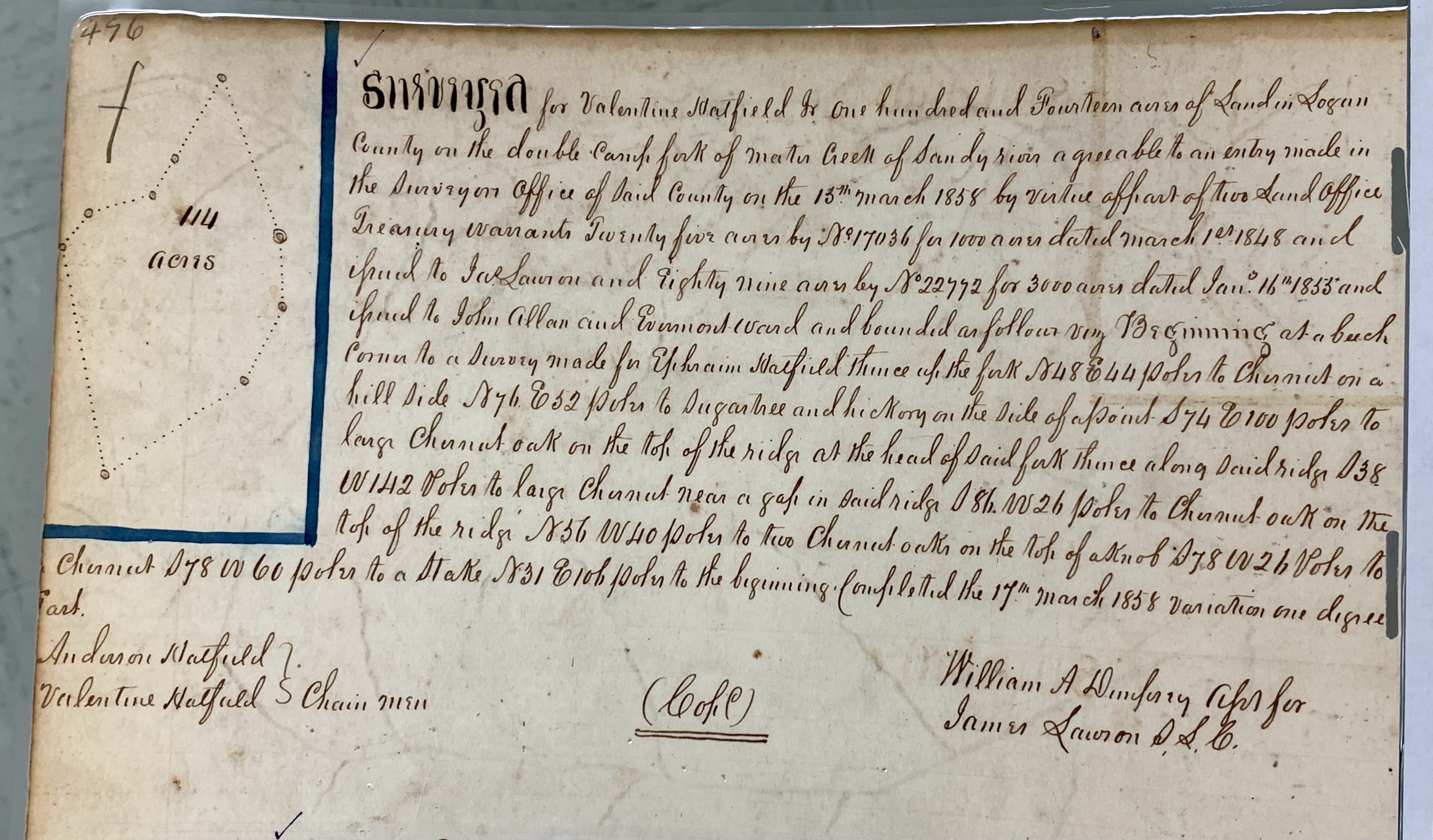
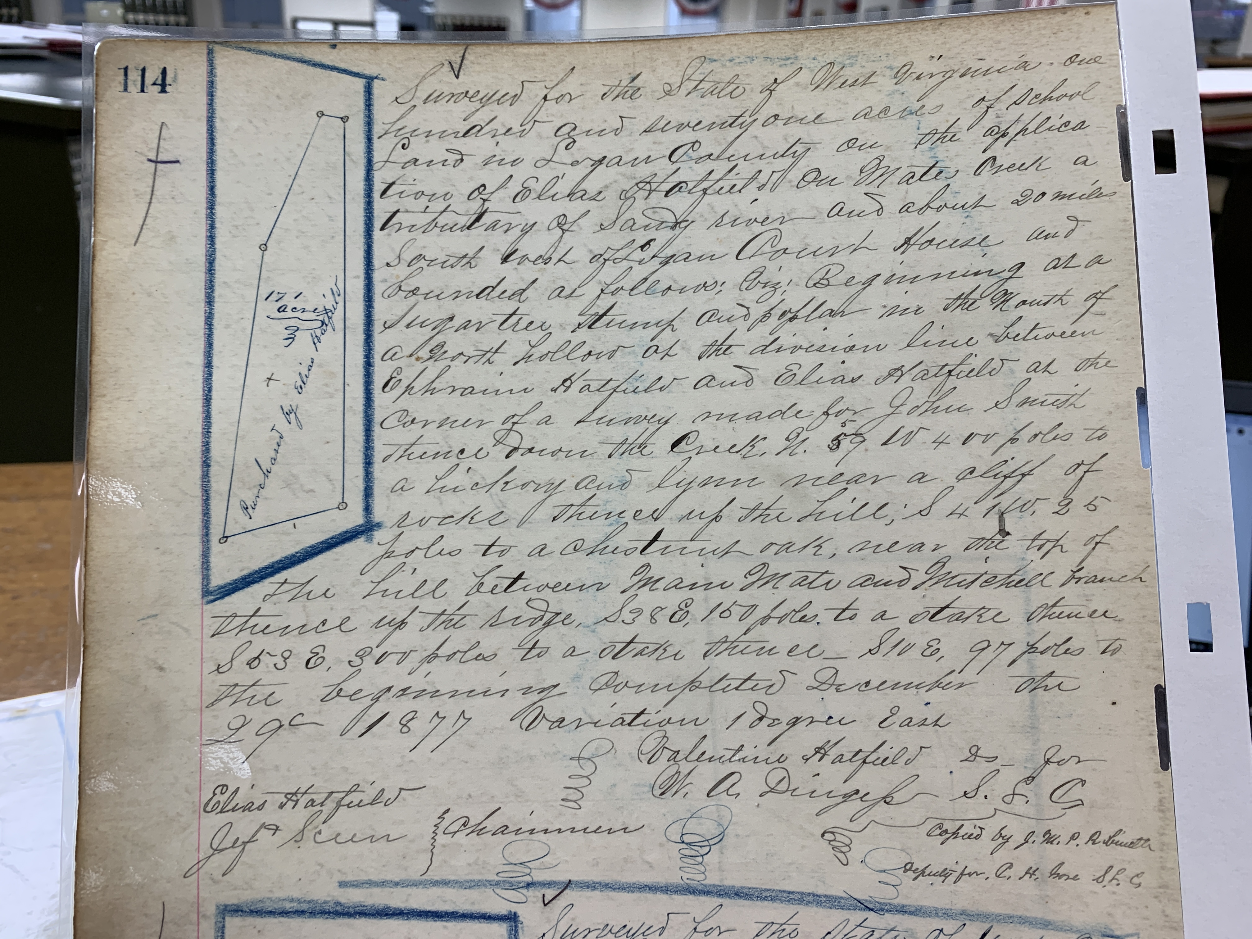
Appalachia, Big Sandy River, Elias Hatfield, Ephraim Hatfield, Hatfield-McCoy Feud, history, John Smith, Logan County, Mates Creek, Mingo County, Mitchell Branch, Valentine Wall Hatfield, W.A. Dingess, West Virginia
02 Tuesday Feb 2021
Posted in Big Sandy Valley, Hatfield-McCoy Feud, Matewan
Tags
Appalachia, Beech Creek, Big Sandy River, Double Camp Branch, Ephraim Hatfield, genealogy, Hatfield-McCoy Feud, history, Lewis Ferrell, Logan County, Magnolia District, Magnolia Township, Mates Creek, Meador Branch, Mingo County, Murphys Branch, Nancy Varney, Patterson Hatfield, Smith Hatfield, Straight Fork, Valentine Wall Hatfield, West Virginia
The following land information is derived from Land Book 1866-1872, Land Book 1873-1874, Land Book 1880-1886, and Land Book 1887-1892 at the Logan County Clerk’s Office in Logan, WV:
Ephraim Hatfield
1865-1867: Magnolia Township
70 acres Murphys Branch, Mate Creek $0.50 per acre no building $35 total
125 acres Meadors Branch, Mate Creek $0.50 per acre no building $62.50 total
115 acres Mate Creek $6.00 $200 building $690 total
45 acres Double Camp $2.00 no building $90 total
20 acres South Side, Mate Creek [added in 1871, five years back tax]
24 acres Straight Fork $3.00 per acre no building $72 total
84 acres Beech Creek $5.00 per acre no building $420 total
1868: Magnolia Township
The book contains no entries for Magnolia Township)
1869-1872: Magnolia Township
70 acres John Murpheys Branch, Mate Creek $0.52 per acre no building $36.75 total
[125-acre tract was gone by 1869, bestowed to Nancy Varney, who had 125 acres on “Meadow” Branch worth $0.52 1/2 in 1869]
115 acres Mate Creek $6.30 per acre $200 building $724.50 total
45 acres Double Camp $2.10 per acre no building $94.50 total
20 acres South Side, Mate Creek $0.52 1/2 per acre no building $10.50 total
24 acres Straight Fork $3.15 per acre no building $75.60 total
84 acres Beech Creek $5.25 per acre no building $441 total
1873: Magnolia District
70 acres John Murpheys Branch, Mate Creek $0.52 per acre no building $36.75 total
[Note: The above building was likely noted in error.]
113 acres Mate Creek $6.30 per acre $200 building $724.50 total
[Note: The 115-acre tract is likely noted as 113 acres in error.]
45 acres Double Camp $2.10 per acre no building $94.50 total
20 acres South Side, Mate Creek $0.52 1/2 per acre no building $10.50 total
24 acres Straight Fork $3.15 per acre no building $75.60 total
84 acres Beech Creek $5.25 per acre no building $441 total
1874: Magnolia District
115 acres Mates Creek $6.30 per acre $200 building $724.50 total
45 acres Double Camp $2.10 per acre no building $94.50 total
20 acres S Side Mate Creek $0.52 per acre 1/2 no building $10.50 total
24 acres Trough? Fork $0.15? per acre no building $75.60 total
[Note: He transferred the 84-acre tract to Valentine Hatfield]
1875: Magnolia District
115 acres Mates Creek $4.00 per acre $45 building $460 total
45 acres Double Camp of Mates Creek $0.25 per acre no building $11.25 total
20 acres Double Camp $0.25 per acre no building $5.00 total
24 acres Strat Fork $0.25 per acre no building $6.00 total
1876: Magnolia District
115 acres Mate Creek $0.25 per acre no building $11.25 total
45 acres Double Camp Mates Creek $0.25 per acre no building $5.00 total
20 acres Double Camp Mates Creek $0.25 per acre no building $6.00 total
24 acres Straight Fork $0.25 per acre no building $18.75 total
1877: Magnolia District
Records are missing for this year.
1878: Magnolia District
15 acres Mates Creek $4.00 per acre $25 building $60 total
20 acres Double Camp Branch Mate Creek $0.25 per acre no building $5.00 total
24 acres Strate Fork Mate Creek $0.25 per acre no building $6.00 total
368 acres Mates Creek $0.10 per acre no building $36.80 total
[Note: In 1878, Ephraim transferred one tract of 100 acres on Mate Creek worth four dollars per acre containing a $25 building with a total worth of $400 to Smith and Patterson Hatfield. He also transferred one tract of 50 acres on Nashes Buck? Hollow Double Camp worth twenty-five cents per acre with no building and total worth of $12.50 to Floyd Hatfield.]
1879: Magnolia District
Records are missing for this year.
1880: Magnolia District
15 acres Mates Creek $4.00 per acre $25 building $60 total
20 acres Double Camp Branch Mate Creek $0.25 per acre no building $5.00 total
24 acres Strate Fork Mate Creek $0.25 per acre no building $6.00 total
68 acres Mates Creek $0.10 per acre no building $36.80 total
[Note: In 1880, Ephraim transferred 300 acres from the 368-acre tract to Ellison Hatfield. Note also that he died before the 1880 census.]
1881: Magnolia District
15 acres Mates Creek $4.00 per acre $25 building $375.00? total
20 acres Double Camp Branch Mate Creek $0.25 per acre no building $99.00 total
24 acres Strate Fork Mate Creek $0.25 per acre no building $200.00
68 acres Mates Creek $0.25 per acre no building $109.00
[Note errors in total valuation for his property.]
1882: Magnolia District
The Hatfield page is missing from records.
1883: Magnolia District
Records are missing for this year.
1884: Magnolia District
15 acres Mates Creek $5.00 per acre $40 building $75 total
20 acres Double Camp Branch $1 per acre no building $20 total
68 acres Mates Creek $1 per acre no building $68 total
[Note: The 50-acre tract was listed under Ephraim, Sr. and was transferred from Floyd Hatfield. The 114-acre tract was transferred from a commissioner.]
1885: Magnolia District
15 acres Mates Creek $5 per acre $40 building $75 total
20 acres Double Camp Branch, Mates Creek $1 per acre no building $20 total
68 acres Mates Creek $1 per acre no building $68 total
1886-1888: Magnolia District
No property is listed for 1886, 1887, and 1888.
Writings from my travels and experiences. High and fine literature is wine, and mine is only water; but everybody likes water. Mark Twain
This site is dedicated to the collection, preservation, and promotion of history and culture in Appalachia.
Genealogy and History in North Carolina and Beyond
A site about one of the most beautiful, interesting, tallented, outrageous and colorful personalities of the 20th Century
