Tags
Appalachia, Hatfield-McCoy Feud, history, justice of the peace, Kentucky, Logan County, Pike County, Sam McCoy, Tolbert Hatfield, Wall Hatfield, West Virginia
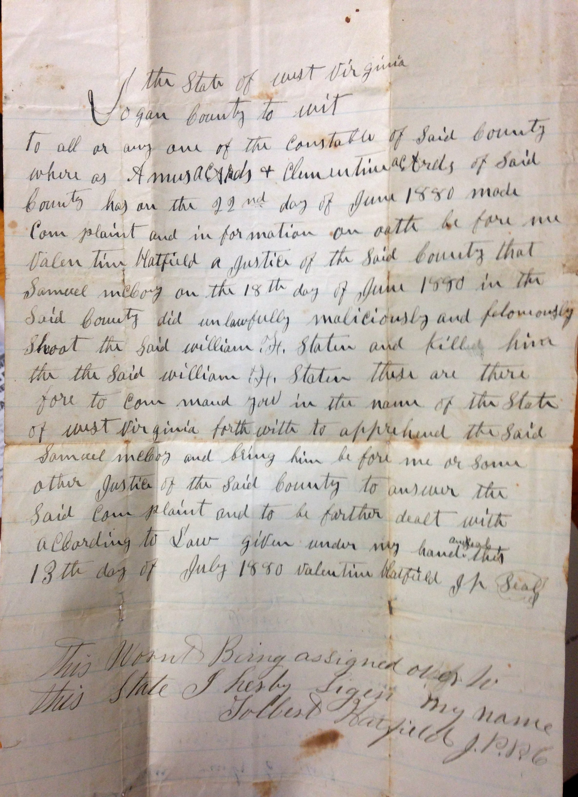
Posted by Brandon Ray Kirk | Filed under Hatfield-McCoy Feud

21 Thursday Apr 2022
Tags
Appalachia, Hatfield-McCoy Feud, history, justice of the peace, Kentucky, Logan County, Pike County, Sam McCoy, Tolbert Hatfield, Wall Hatfield, West Virginia
Posted by Brandon Ray Kirk | Filed under Hatfield-McCoy Feud
21 Thursday Apr 2022
Posted in Hatfield-McCoy Feud, Matewan
Tags
A.W. Ferrell, Asa McCoy, David Mounts, Ephraim Hatfield, genealogy, Hatfield-McCoy Feud, history, John Ferrell, Joseph Simpkins, justice of the peace, Logan County, Magnolia District, Michael A. Ferrell, Mingo County, Samuel F. Varney, Wall Hatfield, West Virginia, William Tiller
The following list of justices of the peace for Magnolia District in present-day Mingo County, West Virginia, is based on historical documents available at the Logan County Courthouse in Logan. Several things to consider: (1) The list will be expanded over time based on new research; (2) the targeted area for this research is the Hatfield-McCoy feud region; (3) some justices included in this list may have in fact been located outside of the feud region; (4) dates for justices are primarily derived from deeds and county court/commissioner records; and (5) Mingo County was formed from Logan County in 1895.
John Ferrell (1838)
April 26, 1838
David Mounts (1838-1840)
April 26, 1838
January 31, 1840
March 23, 1840
August 22, 1840
Samuel F. Varney (1861)
March 14, 1861
Ephraim Hatfield (1861)
March 14, 1861
William Tiller (1867)
October 1867
Valentine “Wall” Hatfield (1870-1885)
February 11, 1873
April 8-9, 1873
August 12-16, 1873
February 10-12, 1874
October 13-14, 1874
December 8-12, 1874
December 29, 1874
August 10, 1875
October 12-16, 1875
August 8-9, 1876
elected October 10, 1876
July 1, 1878
October 1879
July 1880
December 10, 1880
December 14, 1880
appointed June 13, 1881
January 28, 1882
July 22, 1885
Asa McCoy (1873-1876)
February 11-12, 1873
August 12-16, 1873
December 9-12, 1873
June 16, 1874
October 22, 1874
December 9, 1874
February 11, 1875
June 9, 1875
June 13-17, 1876
August 8-9, 1876
Ephraim Hatfield (1876-1878)
elected October 10, 1876
February 11, 1878
A.W. Ferrell (1880)
April 1880
referenced on February 8, 1881 as a former justice
Joseph Simpkins (1882)
appointed to fill unexpired term, October 17, 1882
Michael A. Ferrell (1888)
elected November 6, 1888
12 Wednesday May 2021
Posted in Big Sandy Valley, Matewan
Tags
Alafair Davis, Albert G. McCoy, Appalachia, Asa McCoy, Ephraim Hatfield, genealogy, H.S. Davis, history, Jane Ferrell, John Ferrell, justice of the peace, Logan County, Magnolia District, Magnolia Township, Nellie McCoy, Pigeon Creek, Thacker Fork, Tug Fork, West Virginia, William Tiller
The following land information is derived from Land Book 1866-1872, Land Book 1873-1874, Land Book 1880-1886, and Land Book 1887-1892 at the Logan County Clerk’s Office in Logan, WV:
Asa McCoy (of Logan County)1
[On June 4, 1859, Asa McCoy deeded __ acres on Pigeon Creek to John Ferrell for $__. Deed Book __, page 54. Only part of this deed is recorded. Ephraim Hatfield2 and William Tiller were justices of the peace.]
No property listed in 1865.
1866: Magnolia Township
290 acres South Side Pigeon and Thacker Fork $0.50 per acre no building $145 total
820 acres North Side Pigeon $0.50 per acre no building $410 total
No property listed for 1867-1870.
[On February 29, 1869, John and Jane Ferrell deeded 500 acres on Tug Fork of Sandy River and Sulphur Creek to Asa McCoy for $900. References the store house on the bank of the river, near the mouth of Mates Creek. William Tiller was justice of the peace. Deed Book __, page 208-209.]
1871-1874: Magnolia District
500 acres Sulphur and Sandy River $2 per acre no building $1000 total
1875-1876: Magnolia District
500 acres Sandy River and Sulphur $1.75 per acre $100 building $875 total
[On August 19, 1876, Asa and Nelly McCoy deeded 100 acres between Sulphur Creek and Tug River to Alafair Davis3 (wife of H.S. Davis) for $200. Deed Book __, page __.]
1877: Magnolia District
No records for this year for Magnolia District
1878: Magnolia District
[On February 11, 1878, Asa and Nellie McCoy deeded 150 acres to William McCoy for $500. References the mouth of Mate Creek and the land occupied by William McCoy. Ephraim Hatfield7 was justice of the peace. Deed Book __, page 484-485.]
350 acres Sandy River and Sulphur $1.75 per acre $100 building $612.50 total
1879: Magnolia District
No records for this year for Magnolia District
[On April 15, 1880, Asa and Nellie McCoy deeded 75 acres to A.G. McCoy for $200. References the first hollow below the forks of Sulphur Creek. A.W. Ferrell was a justice of the peace. Deed Book __, page 189-190.]
[On April 15, 1880, Asa and Nellie McCoy deeded 50 acres to Albert G. McCoy for $50. References the first hollow on the right hand side of Sulphur. Deed Book __, page __.]
1880: Magnolia District
350 acres Sandy River and Sulphur $1.75 per acre $100 building $612.50 total
1881: Magnolia District
225 acres Sandy River $1.75 per acre no building $262.50 total
1882: Magnolia District
Pages missing.
1883: Magnolia District
125 acres Sulphur Branch Sandy River $2 per acre [rest blank]
1884-1885: Magnolia District
125 acres Sulpher Branch and Sandy River $2 per acre $75 building $250 total
1886: Magnolia District
125 acres Sulphur of Sandy $2 per acre $75 building $75 total
1887: Magnolia District
125 acres Sulphurr of Sandy River $2 per acre $75 building $250 total
***
1Brother to Sallie (McCoy) McCoy.
2Most likely, this is the father to Devil Anse Hatfield.
3Daughter of Asa and Nelly McCoy
11 Tuesday May 2021
Posted in Big Sandy Valley
Tags
Anna McCoy, Appalachia, Big Sandy River, Cordelia McCoy, David Mounts, Elizabeth Vance, H.H. Williamson, Hezekiah Blankenship, John Ferrell, justice of the peace, Kentucky, Little Blackberry Creek, Logan County, Magnolia Township, Pigeon Roost Bottom, Pike County, Pleasant McCoy, Randolph McCoy, Richard Vance, West Virginia, William A. Dempsey, William McCoy
The following land information is derived from Land Book 1866-1872 at the Logan County Clerk’s Office in Logan, WV:
Randolph McCoy (of Logan County)1
[On December 15, 1837, Randolph McCoy of Logan County deeded 83 acres to Hezekiah Blankenship for $150. References Pigeon Roost Bottom. John Ferrell and David Mounts were justices of the peace. Deed Book __, page 136.]
[On September 17, 1845, Randolph and Anna McCoy of Pike County, KY, deeded 200 acres to Daniel McCoy for $300. Deed Book B, page 538-539.]
[On February 11, 1854, Elizabeth Vance2 deeded __ acres to Randolph McCoy for $300 all her land in Logan County excepting what she has sold to H.H. Williamson and William A. Dempsey. Beginning below the mill seat; references the island below Little Blackberry Creek and the ash gap in the horse ridge. Pleasant McCoy was a justice of the peace. Deed Book __, page 337.]
[On February 11, 1854, Richard Vance3 deeded __ acres to Randolph McCoy for $200 all of his lands in Logan County. Joseph Murphy and P. McCoy were justices of the peace. Deed Book C, page 444-445.]
No property listed in 1865.
1866: Magnolia Township
199 acres Sandy River $2.50 per acre no building $497 total
75 acres Sandy River $1.75 per acre no building $431 total
No property listed thereafter.
***
1Son of William and Cordelia (Campbell) McCoy.
2Mother of Jim Vance.
3Brother of Jim Vance.
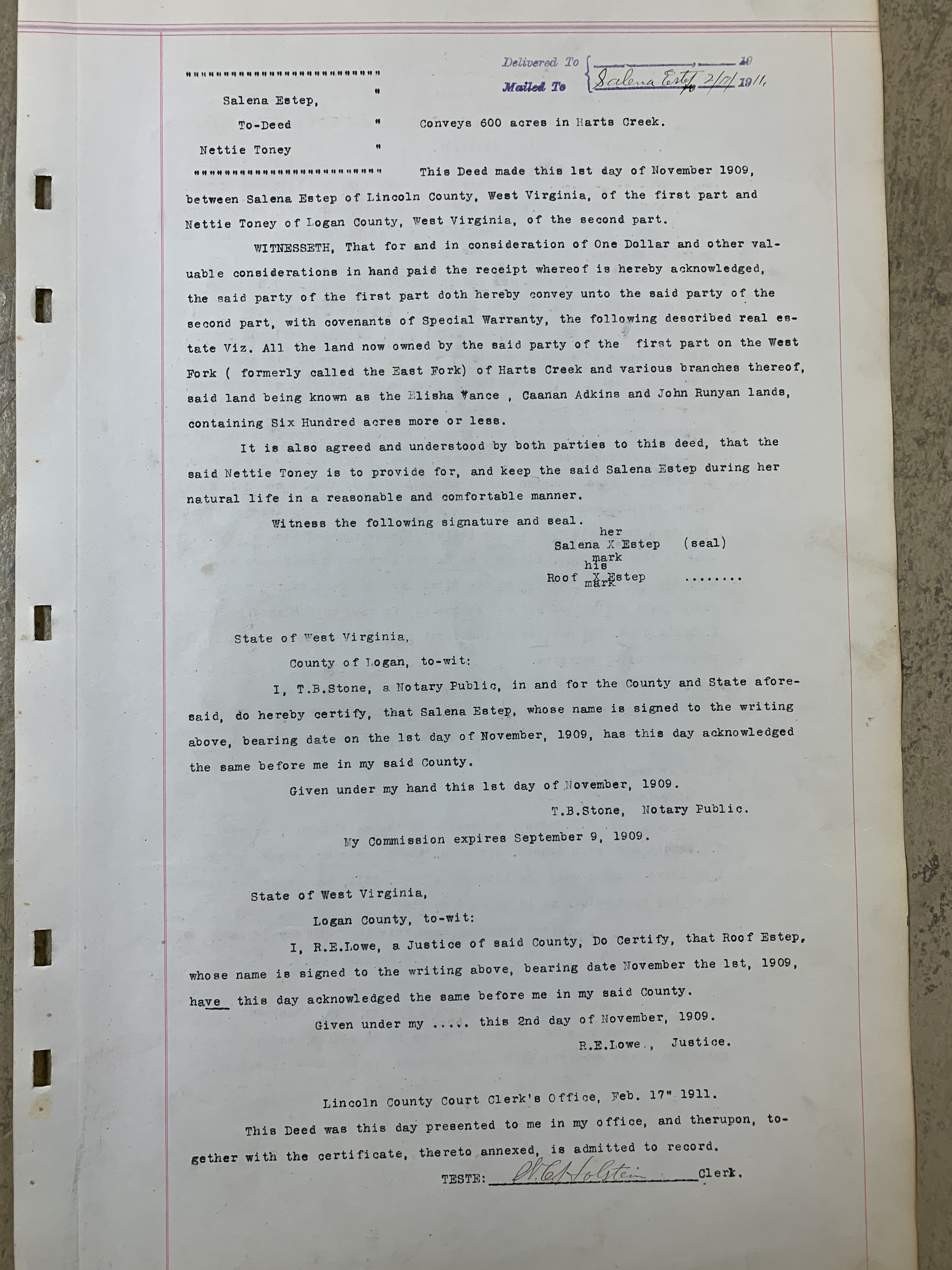
31 Wednesday Mar 2021
Posted in Big Harts Creek, Lincoln County Feud
Tags
Appalachia, Canaan Adkins, East Fork, Elisha Vance, genealogy, Harts Creek, history, John Runyon, justice of the peace, Lincoln County, Lincoln County Feud, Logan County, Nettie Toney, notary public, R.E. Lowe, Salena Estep, T.B. Stone, West Fork, West Virginia
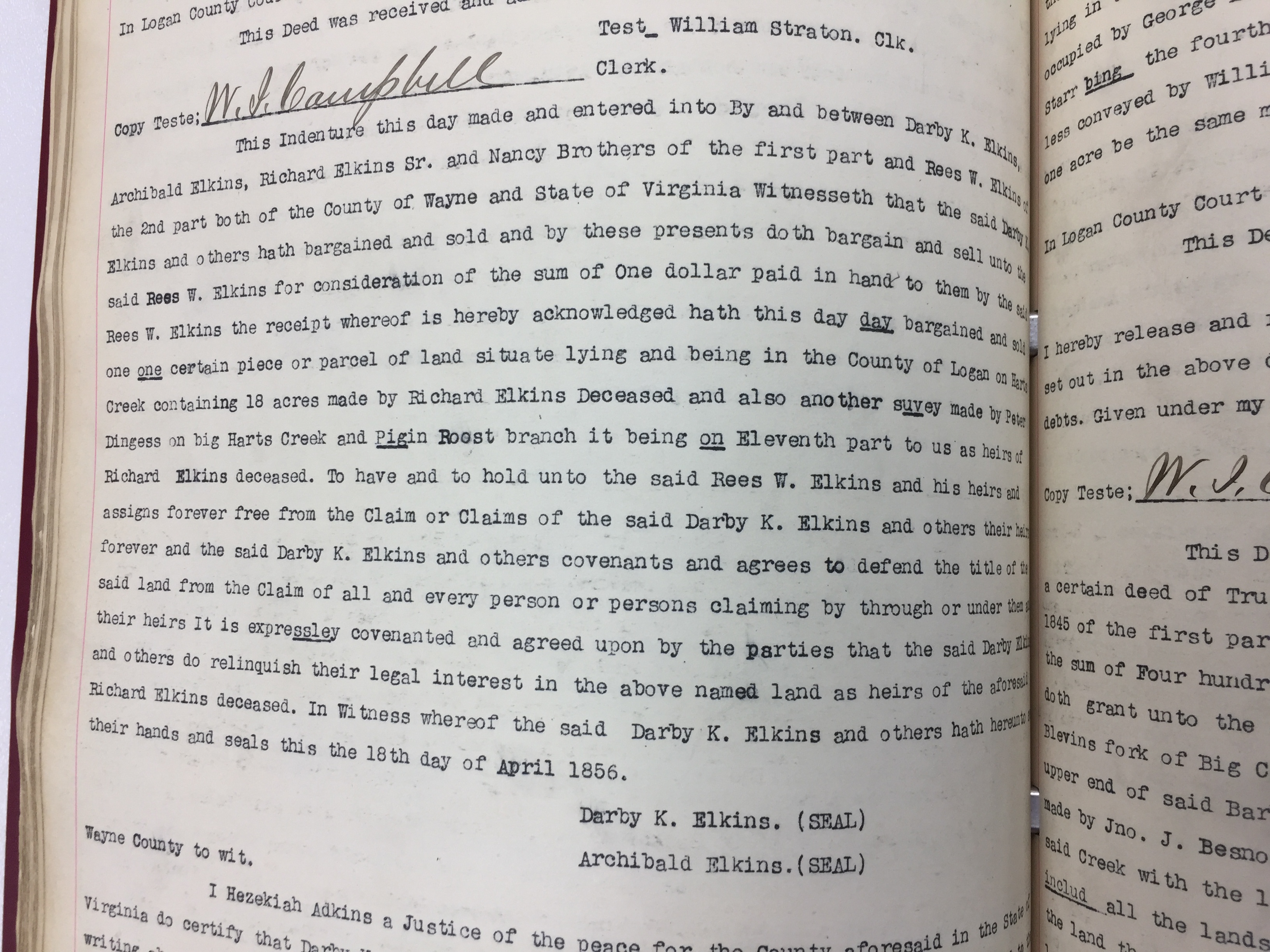
13 Saturday Mar 2021
Posted in Big Harts Creek
Tags
Appalachia, Archibald Elkins, Darby K. Elkins, genealogy, Harts Creek, Hezekiah "Carr" Adkins, history, justice of the peace, Logan County, Nancy Brothers, Pigeon Roost Branch, Reese W. Elkins, Richard Elkins, West Virginia
19 Friday Feb 2021
Posted in Beech Creek, Big Sandy Valley, Matewan, Wharncliffe
Tags
Alex D. Trent, Beech Creek, Ben Creek, Bend Creek, Big Sandy River, David Mounts, Devil Anse Hatfield, Elias Hatfield, Elkhorn Sandy River Trust Company, genealogy, Glen Alum, Grapevine Creek, history, Isabella Rutherford, J.C. Williamson, J.D. Sergeant, Jacob Cline, Jacob Phillips, Jacob Smith, James Vance Jr., John Ferrell, John Francesco, John W. Deskins, Joseph Glen, Julius Williamson, justice of the peace, Kentucky, Lewis Ratcliff, Lewis Rutherford, Logan County, M.A. Ferrell, M.B. Lawson, Magnolia District, Michael A. Ferrell, Mingo County, Morehead, Philadelphia, Pigeon Creek, Richard Ferrell, Richard Maynard, Richard Ratcliff, Richard Ratliff, Right Fork, Roane County, Spring Fork, Spruce Fork, T.W. Blankenship, Thacker Creek, Tug River, Warren Alderson, West Virginia, William Ferrell, William S. Ferrell
What follows is a list of 1000-plus-acre tracts in Magnolia Township/District of Logan County, WV, for 1867, 1870, and 1886-1889…
1867
Jacob Cline’s Heirs, Logan County, 5000 acres, Sandy River
William Ferrell, Logan County, 3900 acres, Sandy River
Richard Maynard, Logan County, 3250 acres, Sandy River
David Mounts, Logan County, 3000 acres, Tug River and Tributaries
John Ferrell, Logan County, 2812 acres, Sandy River
Warren Alderson, Logan County, 2740 acres, Right Fork Ben Creek
John Ferrell, Logan County, 1814 acres, Pigeon Creek
Richard Ratliff, Logan County, 1340 acres, Stafford and Beech Creek
John W. Deskins, Logan County, 1305 acres, Thacker Creek and Sandy River
Warren Alderson, Logan County, 1300 acres, Spring Fork of Ben Creek
John Ferrell, Logan County, 1100 acres, Sandy River
Jacob Phillips, Logan County, 1000 acres, Sandy River
1870
Jacob Cline’s Estate, Logan County, 5000 acres, Sandy River
Richard Ferrell, Logan County, 3900 acres, On Sandy River
John Ferrell, Logan County, 3075 acres, 7 Tracts on Pigeon
David Mounts Estate, Logan County, 3000 acres, Tug Fork and Tributaries
Warren Alderson, Logan County, 2740 acres, Right Fork Ben Creek
Richard Maynard, Logan County, 2430 acres, On Sandy River
John W. Deskins, Logan County, 1305 acres, Turkey Sandy River
Warren Alderson, Logan County, 1300 acres, Spring Fork Ben Creek
William S. Ferrell, Logan County, 1100 acres, Sandy River
1876
Jacob Cline’s Heirs, Kentucky, 5000 acres, Grape Vine and Sandy
William S. Ferrell, Logan County, 3000 acres, Thacker and Sandy River
Warren M. Alderson, Kentucky, 2640 acres, Right Fork of Ben Creek
Isabella Rutherford, Logan County, 1600 acres, Sandy River
Michael A. Ferrell, Logan County, 1300 acres, Sandy River
Warren M. Alderson, Kentucky, 1175 acres, Spring Fork Ben Creek
Richard Ratcliff, Logan County, 1140 acres, Stafford Branch Sandy
Julius Williamson, Logan County, 1000 acres, Sandy and Branches
1886
William S. Ferrell, Logan County, 2650 acres
Warren Alderson, Morehead KY, 2640 acres, Sandy River
Lewis Rutherford, Logan County, 1600 acres
Jacob Smith, Mouth of Pond KY, 1500 acres
James Vance, Jr., Logan County, 1500 acres
J.D. Sergeant, Philadelphia PA, 1481 acres
Elias Hatfield, Logan County, 1431 acres
M.A. Ferrell, Logan County, 1300 acres
T.W. Blankenship, Roane County, 1200 acres
1887
William S. Ferrell, Logan County, 2650 acres, Thackers Creek and Sandy River
Warren Alderson, Morehead KY, 2640 acres, Sandy River
Anderson Hatfield, Logan County, 2360 acres, Grape Vine
J.D. Sergeant, Philadelphia PA, 1481 acres, Beech Creek
Elias Hatfield, Logan County, 1471 acres, Four tracts on Mates Creek
M.A. Ferrell, Logan County, 1300 acres, Sandy River
T.W. Blankenship, Roane County, 1200 acres, Spruce Fork of Ben Creek
1888
Anderson Hatfield, Logan County, 2656 1/2 acres, Grapevine Creek
William S. Ferrell, Logan County, 2650 acres, Thacker and Sandy
J.C. Williamson, Logan County, 1837 acres, Four tracts on Alum and Sandy River
Lewis Ratcliff, Logan County, 1600 acres, Sandy River
John Francesco, Logan County, 1500 acres, Grapevine and Thacker
Simpkins and M.B. Lawson’s Heirs, Logan County, 1500 acres, Richard Ratcliff Farm and Sandy River
Elkhorn Sandy R. Trust Co., Logan County, 1481 acres, Ben Creek and Sandy
J.D. Sergeant, Philadelphia PA, 1385 acres, Sandy River
M.A. Ferrell*, Logan County, 1300 acres, Sandy River
1889
Anderson Hatfield, Logan County, 2656 1/2 acres, Grapevine Creek
W.S. Ferrell, Logan County, 2650 acres, Thacker and Sandy River
J.C. Williamson, Logan County, 1837 acres, 4 Tracts on Alum and Sandy River
Lewis Rutherford, Logan County, 1600 acres, Sandy River
Jacob Smith, Logan County, 1500 acres, Richard Ratcliff’s Farm and Sandy River
John Francesco, Logan County, 1500 acres, Grape Vine
Elkhorn Sandy River Trust Company, Logan County, 1481 acres, Ben Creek and Sandy River
J.D. Sergeant, Philadelphia PA, 1385 acres, Sandy River
Joseph Glen, Logan County, 1377 acres, Tug River Below Mouth Bend
J.D. Sergeant, Philadelphia PA, 1354 1/4 acres, Mates Creek
J.D. Sergeant, Philadelphia PA, 1338 3/4 acres, Grapevine
M.A. Ferrell*, Logan County, 1300 acres, Sandy River
Alex D. Trent, Logan County, 1246 acres, Spring Fork Ben Creek
Note: On November 6, 1888, M.A. Ferrell was elected justice of the peace; his term commenced on January 1, 1889.
Source: Land Book 1866-1872, Land Book 1873-1874, Land Book 1880-1886, and Land Book 1887-1892.
18 Thursday Feb 2021
Posted in Big Sandy Valley, Hatfield-McCoy Feud, Matewan
Tags
Appalachia, Ben Creek, Big Sandy River, Devil Anse Hatfield, genealogy, Grapevine Creek, H.R. Phillips, Hatfield-McCoy Feud, history, J.D. Sergeant, Johnse Hatfield, Johnson Hatfield, justice of the peace, Left Hand Fork, Levicy Hatfield, Lick Branch, Lick Fork, Logan County, Magnolia District, Mingo County, Nancy Hatfield, Philadelphia, Thacker Creek, Valentine Wall Hatfield, West Virginia
The following land information is derived from Land Book 1880-1886 and Land Book 1887-1892, as well as deed books, at the Logan County Clerk’s Office in Logan, WV:
Johnson Hatfield
No property listed in land books for 1865-1881.
On January 28, 1882, Anderson and Vicy Hatfield deeded 200 acres at Lick Fork of Grapevine Creek to Johnson Hatfield (all of Logan County) for $250. Began at a large rock near the creek bank just above the garden field at the mouth of Lick Fork, thence running out to the center of the point above Lick Fork…to the head of Lick Fork and down the top of the ridge between Grapevine and Thacker Creek… Anderson and Vicy Hatfield signed the deed. Justice Valentine Hatfield witnessed the deed on January 28, 1882.
No property listed in land books for 1883.
1884-1885: Magnolia District
Johnson Hatfield, Jr.
200 acres Lick Branch, Grape Vine $1.25 per acre no building $250 total
Johnson Hatfield, Sr.
200 acres Lick Branch, Grape Vine $1.25 per acre no building $250 total
[Note: Two entries exist in the land book for a Johnson Hatfield (Sr. and Jr.) in 1884-1885; this is likely the same person and the same property.]
1886: Magnolia District
No entry for him.
1887: Magnolia District
Nancy Hatfield
300 acres Grapevine, Sandy River $1.25 per acre no building $375 total
[Note: This property was transferred from Johnson Hatfield. Presumably, “Nancy Hatfield” is Johnse’s wife, the former Nancy McCoy.]
1888: Magnolia District
No entry for Johnson or Nancy Hatfield.
[Note: On January 30, 1888, Johnson Hatfield, Jr. transferred 500 acres on Grapevine, Sandy River (two tracts) worth $1.25 and total value of $625 to J.D. Sergeant of Philadelphia, PA.]
1889: Magnolia District
No property listed.
1890: Magnolia District
Nancy Hatfield
147 acres H.R. Fk Mates Creek $1 per acre no building $147 total
[Note: This may be Johnse’s wife, Nancy.]
1891: Magnolia District
No property listed.
[In 1891, “Jo Hatfield & wife” transferred 258 acres on Left Hand Fork Ben Creek worth $1 per acre and with total value of $258 to H.R. Phillips, trustee. This may or may not be Johnse Hatfield.]
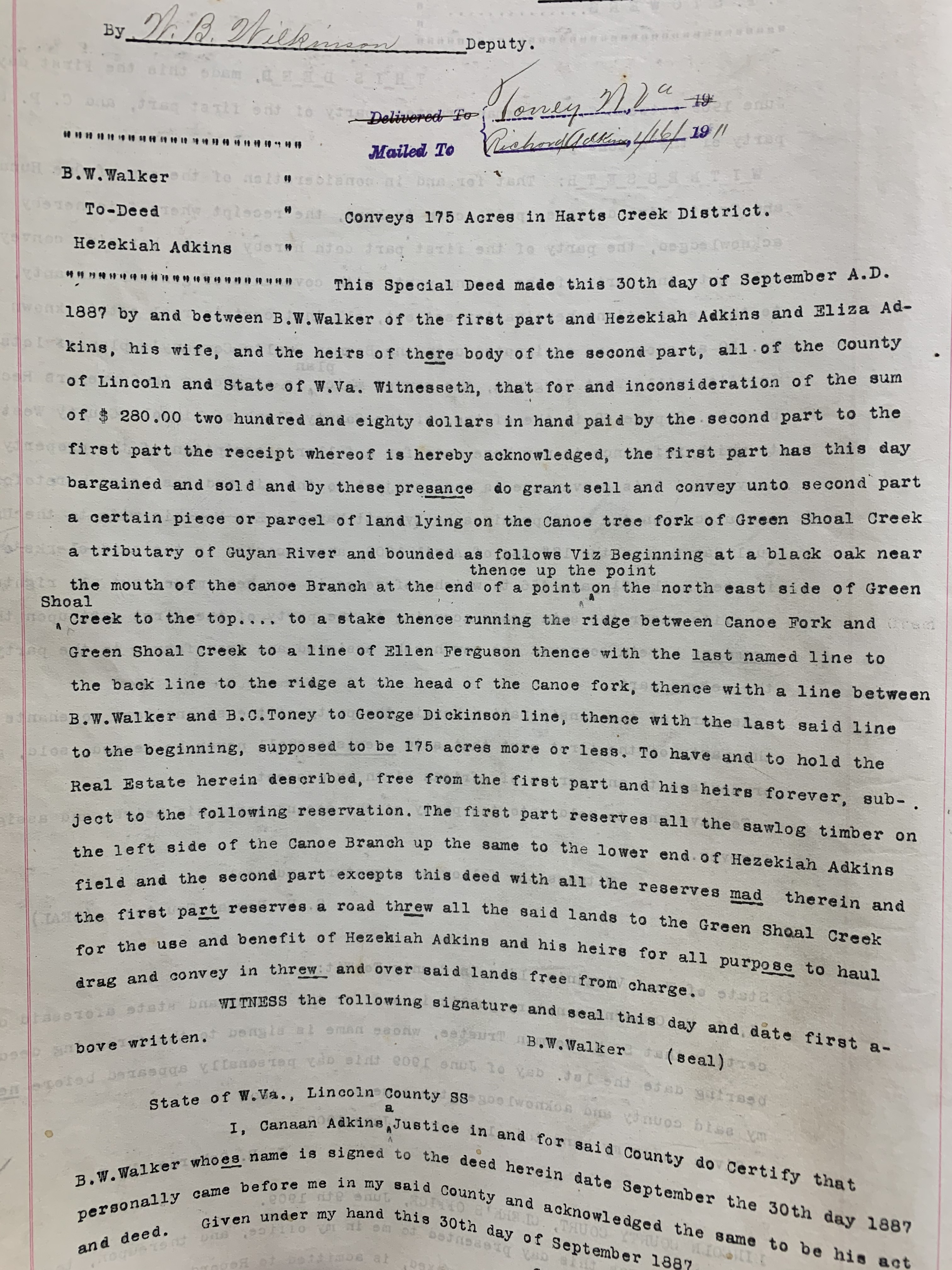
15 Monday Feb 2021
Tags
Appalachia, Ben Walker, Burbus C. Toney, Cain Adkins, Canoe Tree Fork, Eliza Adkins, Ellen Ferguson, genealogy, George Dickinson, Green McCoy, Green Shoal Creek, Guyandotte River, Harts Creek District, Hezekiah Adkins, history, justice of the peace, Lincoln County, Lincoln County Feud, timber, timbering, West Virginia
12 Friday Feb 2021
Posted in Big Sandy Valley, Hatfield-McCoy Feud, Matewan
Tags
A.E. Steel, Anna Hatfield, Appalachia, Beech Creek, Big Sandy River, Charles R. Mounts, Conley Bottom, Conleys Creek, Daniel Christian, Dempsey Branch, Devil Anse Hatfield, Double Camp, Double Camp Branch, E.S. Murphy, Ephraim Hatfield, Floyd Hatfield, genealogy, George Hatfield, Grapevine Creek, Harrison Steel, history, Island Creek, J.D. Sergeant, Jacob Francesco, James A. Nighbert, James Ferrell, James Mounts, John Green, Johnson Hatfield, justice of the peace, L.D. Steel, Levicy Hatfield, Lewis Steel, Lick Fork, Little Kanawha Lumber Company, Logan County, Logan District, logging, Magnolia District, Magnolia Township, Mash Field, Mate Creek, Mates Creek, Meadow Branch, Mill Seat Fork, miller, Mingo County, Moses Christian, Nancy Hatfield, Philadelphia, Pigeon Creek, Plyant Mayhorn, Polly Hatfield, Preacher Anse Hatfield, Road Fork, Samuel Mayhorn, splash dams, splashing, Stuart Wood, Thacker Creek, timbering, Tug Fork, Tug River, Valentine Wall Hatfield, West Virginia, William Tiller, Wolf Pen Fork
The following land information is derived from Land Book 1866-1872, Land Book 1873-1874, Land Book 1880-1886, Land Book 1887-1892, and Land Book 1893-1899, as well as various deed books, at the Logan County Clerk’s Office in Logan, WV:
Anderson Hatfield
[Property listed in name of Levecy Hatfield in 1869, Levica Hatfield in 1870-1871, Levisa Hatfield in 1872, 1874, and 1876, Levitna Hatfield in 1873, Lavisa Hatfield in 1875, Levica Hatfield in 1889, Lovicy Hatfield in 1890-1891, Lovica Hatfield in 1892, and Levicy Hatfield in 1893.]
No property listed in land books for 1865-1867.
On October 19, 1867, George* and Nancy Hatfield of Pike County, KY, deeded 100 acres on Mate Creek to Levicy Hatfield of Logan County, WV, for five hundred dollars. The property began in the upper end of Mash Field and extended to the mouth of Meadow Branch. Witnessed by JP William Tiller on October 19, 1867.
No property listed in the land book for 1868.
1869: Magnolia Township
100 acres Mates Creek $4.20 per acre no building $420 total
55 acres Mates Creek $2.10 per acre $75 building $136.50 total
[Note: Based on the land book, both tracts were acquired in 1869 from George Hatfield of Kentucky. Also, the 55-acre total value figure did not include the value of the building. Note the actual date of purchase for one of the tracts was 1867, as per the deed.]
1870: Magnolia Township
100 acres Mates Creek $4.20 per acre no building $420 total
55 acres Mates Creek $2.10 per acre no building $136.50 total
1871-1872: Magnolia Township
100 acres Mates Creek $4.20 per acre no building $420 total
55 acres Mates Creek $2.10 per acre no building $115.50 total
[Note discrepancy in the valuation for the 55-acre tract.]
1873: Magnolia District
100 acres Mates Creek $5.25 per acre no building $441 total
55 acres Mates Creek $4.20 per acre no building $420 total
1874: Magnolia District
100 acres Mates Creek $4.20 per acre no building $420 total
55 acres Mates Creek $2.10 per acre $115.50 total
On December 29, 1874, Anderson and Lovicy Hatfield sold 200 acres to Polly Hatfield (all of Logan County) for $780 on Mates Creek. Began at the foot of the north hill at the upper end of the old Mash Field, a conditional corner between Ephraim Hatfield and Anderson Hatfield to the mouth of Meadow Branch to include all the land that George Hatfield had deeded to Lovicy Hatfield. Anderson and Lovicy signed the deed using an “x.” Justice of the peace Valentine Hatfield witnessed the deed on December 29, 1874.
[Note the original 100 acres from the 1867 deed has now become 200 acres.]
1875: Magnolia District
100 acres Mates Creek $4 per acre $50 building $400 total
55 acres Mates Creek $0.25 per acre no building $13.75 total
1876: Magnolia District
100 acres Mates Creek $4 per acre no building $400 total
55 acres Mates Creek $0.25 per acre no building $13.75
[Note: In 1876, according to the land book, Anderson Hatfield transferred 200 acres on Mates Creek worth $0.25 per acre and with a total worth of fifty dollars to Polly Hatfield; the deed is dated 1874 (see above); the 1878 land record corrected the acreage to 55 acres by order of P.A. Counts]
1877: Magnolia District
No records available for this year.
On July 2, 1877, Anderson and Lovicy Hatfield deeded 150 acres at Double Camp and Road forks of Mates Creek for $75 to Floyd Hatfield (all of Logan County). Began at the back line of the John Green survey below Double Camp, then up the main ridge to the top of the point above Road Fork, thence to John Green survey line. Anderson and Lovicy signed the deed using an “x.” Justice of the Peace Valentine Hatfield witnessed the deed on July 2, 1877.
On December 24, 1877, Anderson and Levisa Hatfield deeded 1500 acres on Grapevine Creek to James Vance, Jr. (all of Logan County) for $1400. Began near the mouth of Wolf Pen Fork, thence to the top of the mountain between Grapevine and the river, thence with mountain to dividing ridge between Grapevine and Beech Creek, thence to head of Thacker Creek, thence down ridge between Thacker and Mates Creek… References the ridge between the Wolf Pen and Mill Seat Fork. Anderson and Levicy signed the deed using an “x.” Justice Valentine Hatfield witnessed the deed on December 24, 1877.
1878: Magnolia District
Anse Hatfield owned no property in 1878.
[In 1878, as per the land book, Anderson Hatfield transferred 150 acres on Double Camp and Road Fork of Mate to Floyd Hatfield worth twenty cents per acre and with a total worth of $20. Records showed this as “transferred from Anderson Hatfield.” Note: The deed (above) shows the transfer as 1877.]
1879: Magnolia District
No records exist for this year.
1880-1881: Magnolia District
As per land book, Anse Hatfield owned no land.
On December 9, 1880, Anderson Hatfield, Lovicy Hatfield, Elias Hatfield, and Henry Mitchell deeded 200 acres on Wolf Pen Fork of Grapevine Creek to Robert Cox (all of Logan County) for $200. Anderson Hatfield, Lovicy Hatfield, Elias Hatfield, and Henry Mitchell signed the deed. Justice of the peace Valentine Hatfield witnessed the deed on December 10, 1880.
1882: Magnolia District
The Hatfield page is missing from the land book.
On January 28, 1882, Anderson and Vicy Hatfield deeded 200 acres at Lick Fork of Grapevine Creek to Johnson Hatfield (all of Logan County) for $250. Began at a large rock near the creek bank just above the garden field at the mouth of Lick Fork, thence running out to the center of the point above Lick Fork…to the head of Lick Fork and down the top of the ridge between Grapevine and Thacker Creek… Anderson and Vicy Hatfield signed the deed. Justice Valentine Hatfield witnessed the deed on January 28, 1882.
1883: Magnolia District
Records for this district are blank.
1884: Magnolia District
37 acres Tug River $1 per acre no building $37 total
2900 acres Grape Vine, Tug River $1.25 per acre $50 building $3625 total
[Note: In 1884, Anse transferred 100 acres to Daniel Christian on Grape Vine and Sandy River worth $1.25 per acre with no building and valued at $125. In 1884, Anse transferred 150 acres on Beech Creek and Sandy River to Jacob Francesco worth $1 per acre with no buildings and total value at $150. This latter tract states “by A. Hatfield by P. Mayhorn” and adds that “books don’t show A. Hatfield is owner.” Anse is not named in the 1884 deed to Jacob Francesco.]
1885: Magnolia District
37 acres Tug River $1 per acre no building $37 total
2750 acres Grapevine Creek and Tug River $1.25 per acre $50 building $3437.50 total
[In 1885, he transferred 50 acres on Sandy River to Moses Christian worth $1.25 per acre with a total worth of $62.50. In 1885, he transferred 100 acres on Grapevine Creek to Samuel Mayhorn worth $1.25 per acre with a total worth of $125.]
1886: Magnolia District
No property listed for him in 1886.
[In 1886, he transferred 500 acres on Pigeon Creek to James Ferrell worth $1.12 per acre with a total worth of $500. This note referenced him as “A. Hatfield Sr.” In 1886, he transferred 25 acres on Tug River to E.S. Murphy worth $1 per acre and a total worth of $25. In 1886, he transferred 340 acres on Beech Creek to Harrison Steel valued at $2.25 per acre and with a total worth of $765. This latter note stated: “2 years back tax and with interest; transferred from Ans Hatfield.”]
1887: Magnolia District
37 acres Tug River $1 per acre no building $37 total
2360 acres Grape Vine $1.25 per acre $50 building $2950 total
[Note: For both entries, the record reads: “one yr bk tax & interest.” In 1887, he transferred 69 acres on Sandy River worth $1 per acre and total worth of $69 to James Mounts. In 1887, he transferred with others 100 acres on Sandy River worth $1 per acre and total value of $100 to Charles R. Mounts. In 1887, he transferred 200 acres on Beech Creek to Harrison Steel worth $1 per acre and total value of $200.]
1888: Logan District
[On April 10, 1888, Lewis S. Steel sold 200 acres on Island Creek to Vicie Hatfield for $900. Deed Book L, p. 53.]
[On May 1, 1888, Anse and Levicy Hatfield agreed to a quit claim deed for mineral rights to 600 acres in the head of Island Creek to Stuart Wood for $1, and fifty cents per acre once surveyed and the title perfected. Deed Book K, p. 158-159.]
[On May 10, 1888, L.D. and A.E. Steel sold 250 acres on Island Creek to Levicy Hatfield for $500. Deed Book L, p. 52.]
1888: Magnolia District
No property listed for him, but a note in 1893 lists back taxes owed for:
Anderson Hatfield
2656 1/2 acres Grapevine Creek $3.50 per acre no building $9297.75 total
[Note: In 1888, he transferred 300 acres on Grapevine, Sandy River worth $1.25 per acre and total value of $375 to J.D. Sergeant of Philadelphia, PA. In 1888, he transferred along with others 1385 acres on Sandy River worth $1.25 per acre and total worth of $1632 to J.D. Sergeant.]
1889: Logan District
Levica Hatfield
250 acres Island Creek $1 per acre no building $250 total
200 acres Island Creek $1.40 per acre no building $280 total
1889: Magnolia District
Anderson Hatfield
2656 1/2 acres Grapevine Creek $3.50 per acre no building $9297.75 total
[On April 9, 1889, Anse and Levisy Hatfield deed to James E. Price, trustee, for $825 the mineral rights of 821 acres on Island Creek. Deed Book 47, p. 67-70.]
[On September 6, 1889, Anse Hatfield deeded all of the timber on his Island Creek property to the Little Kanawha Lumber Company for $352. References Anse having the right to put in a grist mill at the splash dam. Deed Book O, p. 410-411.]
1890-1891: Logan District
Lovicy Hatfield
250 acres Island Creek $1 per acre no building $250 total
200 acres Island Creek $1.40 per acre no building $280 total
[On November 21, 1891, Anse and Levicy Hatfield deeded to Stuart Wood and J.A. Nighbert for one dollar a right of way for splashing timber at the 821 acres. References Conley Bottom, the mouth of Dempsey Branch, and Conley’s Creek. Deed Book M, p. 189.]
1890-1891: Magnolia District
Anderson Hatfield
2656 1/2 acres Grapevine Creek $3.50 per acre no building $9297.75 total
1892: Logan District
Lovica Hatfield
250 acres Island Creek $2 per acre no building $500 total
200 acres Island Creek $5 per acre $500 building $1000 total
[On June 18, 1892, Anse and Levicy deeded to G.R. Buskirk for $2 his timber on 400 acres. Deed Book Q, p. 370.]
1892: Magnolia District
Anderson Hatfield
2656 1/2 acres Grapevine Creek $3.50 per acre no building $9297.75 total
1893-1894: Logan District
Levicy Hatfield
250 acres Island Creek $2 per acre no building $500 total
200 acres Island creek $5 per acre $500 building $1000 total
1893: Magnolia District
Anderson Hatfield
2656 1/2 acres Grapevine Creek $3.50 per acre no building $9297.75 total
[Note: In 1893, the tract at Grapevine Creek was noted: “entered with 5 yrs back taxes and interest.”]
1894: Magnolia District
Anderson Hatfield
2656 1/2 acres Grapevine Creek $3.50 per acre no building $9298 total
*George Hatfield (1804-1883), son of Ephraim and Anna (Musick) Hatfield; father of “Preacher Anse” Hatfield.
NOTE: Many discrepancies exist between the land books and deeds for Anderson Hatfield.
02 Saturday Jan 2021
Posted in Atenville, Guyandotte River, Little Harts Creek
Tags
Appalachia, Charles Adkins, county clerk, genealogy, Guyandotte River, Harts Creek District, history, J.B. Rigsbey, justice of the peace, Lincoln County, Little Harts Creek, Paris "Witch" Brumfield, Vira Brumfield, W.C. Holstein, West Virginia, William Harrison Tomblin, William Workman

09 Wednesday Dec 2020
Tags
Appalachia, Dug and Dad, justice of the peace, Logan, Logan Banner, Logan County, poetry, poets, Thomas C. Whited, West Virginia, writers
From the Logan Banner of Logan, WV, comes this poem by T.C. Whited titled “Dug and Dad”, written on May 30, 1928, and published on June 5, 1928:
DUG AND DAD
The voting now is over,
And I am rather glad
As we will have for J’s and P’s
Our good old “Dug and Dad.”
The other boys were good old “scouts”
Not one of them is bad,
But did not have the pull it seems
Like “Uncles Dug and Dad.”
If we don’t be more careful
Our days will be long and sad
As we pull the time and pay the fine
As fixed by “Dug and Dad.”
27 Tuesday Oct 2020
Posted in Battle of Blair Mountain, Logan
Tags
Appalachia, Battle of Blair Mountain, Bilton McDonald, C.S. Minter, crime, Don Chafin, F.O. Woerner, F.R. Remlinger, F.S. Schuster, First National Bank, Fulton Mitchell, H.C. Hill, history, justice of the peace, labor, Logan, Logan Banner, Logan County, Mine Wars, Naaman Jackson, sheriff, Sidney B. Lawson, true crime, United Mine Workers of America, W.S. Bradshaw, West Virginia
From the Logan Banner of Logan, WV, comes this item dated September 9, 1921 about the “armed march” on Logan County by union miners:
TROOPS END GREAT CONFLICT
CITIZENS MEET TO SEND THANKS TO SISTER COUNTIES WHO SO NOBLY HELPED
The war is over!
With the arrival of federal troops Saturday and the relieving of the boys along the battle sector Sunday morning Logan citizens started to regain rest which has been denied for two weeks. All Sunday afternoon special trains were speedily filled up and started on their way with tired but happy men, for their homes up and down the county and to our neighboring counties who so willingly came to our help at a time when days looked very black for the future of our beautiful county.
Every man a volunteer and every one ready for action as soon as he arrived in Logan. Logan will never forget the sacrifice made.
Monday evening in answer to a call issued, the circuit court room filled with citizens of Logan to give thanks and offer resolutions to those helping us and to the counties who so nobly responded to our calls for help.
The meeting was opened by Clarence McD. England and Naaman Jackson, president of the First National Bank was elected chairman. Committees were immediately appointed to draw up the resolutions. During the time the committees were preparing the resolutions several impromptu speeches were made. The speakers included Attorney Lilly and Chafin. Mr. Chafin emphasized the fact that it was due to Kanawha county’s failure to properly cope with the situation at the time when it could have been handled without bloodshed that it become necessary for Logan to mobilize an army under arms to protect its rights as a county. He brought forth rousing cheers when he stated that Logan county has a sheriff who had made the statement that “they shall not pass” and now they could say “THEY DID NOT PASS!” The fighting parsons were called for. They were the Reverends Coffey and Dodge.
Rev. Dodge said we had taught the rednecks the meaning of “Love” as it had been taught to him when a child–that of the application of a slipper to a part of his anatomy. He said it was in this manner he preached the meaning of the word and felt in this way Logan had showed her love for those who were fighting under the red flag through ignorance but who have now laid down their arms to resume the more peaceful pursuit of “live and let live.”
Justice of the Peace Fulton Mitchell was called on for a speech relative to the treatment received at the hands of the enemy when he and his three companions were captured and held for more than a week. His remarks were of the same content as will be found in another column of this issue.
In due time the resolutions had been prepared and read to those present and were speedily adopted and have been sent to the counties specified.
They are as follows:
Logan, Logan County, West Va.,
September 5, 1921
To the Officials and Citizens of our Neighboring West Virginia Counties, and the Western Counties of Virginia, whose Aid and Counsel was so Freely and Generously given to us at the time of the threatened invasion of our boundaries:
GREETING:
The representative citizenship of Logan county, West Virginia, in mass meeting on this day assembled, do hereby earnestly and publicly express to you and each of you, our sincere and hearty thanks and appreciation for the substantial, timely and very valuable aid and assistance rendered to our county and our citizenship during the recent attempted invasion of our boundaries by a misguided and hostile mob, imbued with the spirit of anarchy and fighting under the red flag.
The value of the help brought by the men who came to us from your counties cannot be overestimated. The organization was soon perfected and proved effective in holding back the invaders.
While your men were with us they showed fine courage and devotion to duty; their bearing was always that of courteous gentlemen, and the citizens of Logan county most heartily thank you and your gallant men for the splendid help given.
We hope the occasion will never arise when you will need similar assistance, but, if such a crisis should occur, our men will be found ready to respond.
Respectfully,
REV. W.S. BRADSHAW
F.S. SCHUSTER
F.O. WOERNER
C.S. MINTER
DR. H.C. HILL
Resolutions Committee.
The foregoing resolution was unanimously adopted at a mass meeting held in the City of Logan, September 5, 1921.
NAAMAN JACKSON, Chairman.
F.S. SCHUSTER, Sec’y.
In mass meeting assembled at County Court House in Logan, September 5th, 1921:
The citizens of Logan county–
RESOLVED: That the actions and efforts of the Logan county officials as well as those of the loyal men and women, are most heartily commended and approved, and it is further
RESOLVED: That the final results of such are most gratefully acknowledged and appreciated, and be it
RESOLVED: That a copy of these resolutions be printed in our local newspapers.
DR. S.B. LAWSON
F.R. REMLINGER
BILTON McDONALD
Committee.
17 Tuesday Mar 2020
Tags
Appalachia, crime, farming, genealogy, Gilbert Creek, H.E. Ellis, history, James E. McDonald, James Stimpson, Joseph Bragg, justice of the peace, Logan, Logan County, Logan County Banner, logging, M.A. Hatfield, merchant, Mingo County, timbering, West Virginia, William Johnson
From the Logan County Banner of Logan, WV, come these items about Gilbert in present-day Mingo County, WV, dated 1894:
On yesterday William Johnson lodged James Stimpson and Joseph Bragg in jail here. They were sent on for further trial by Justice M.A. Hatfield, on a charge of breaking into the store of H.E. Ellis, on Gilbert creek. The boys confessed to the offense.
Logan County Banner (Logan, WV), 24 May 1894
***
From Waco, written on July 7, 1894 from Gilbert:
EDITOR BANNER: Farmers are very busy with their crops. Corn is looking as well as could be expected. Oats in most cases are promising.
Two or three applications have been made for our school, but it is thought that Prof. James E. McDonald will teach it.
That log tide which failed to materialize makes it hard on taxpayers and merchants.
Logan County Banner (Logan, WV), 12 July 1894
16 Sunday Feb 2020
Posted in Tom Dula
Tags
Appalachia, Brandon Kirk, crime, Elkville, history, justice of the peace, Laura Foster, North Carolina, photos, Phyllis Kirk, Pickins Carter, Tom Dula, true crime, Wilkes County, Wilkes County Jail, Wilkesboro

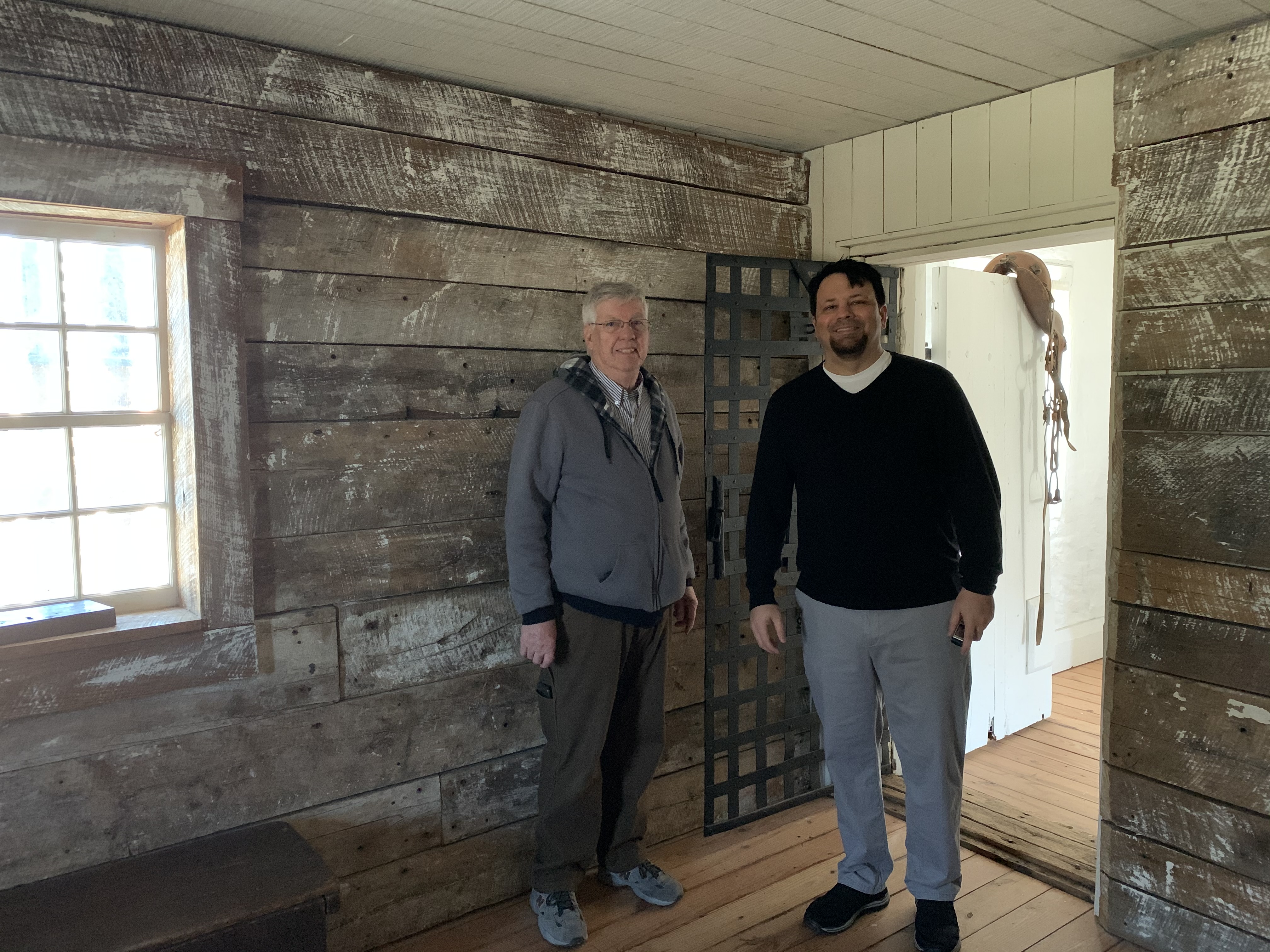
The Wilkes County Jail was built in 1859. Here’s our guide showing us the jail cell on the lower floor. 8 January 2020

All three cells have the original doors, wood, and iron bars. The keys still operate the door! 8 January 2020

The jail was used until 1915, when it was converted into apartments. It was scheduled for demolition in 1968 but a local group saved it. It began operation as a museum in the 1970s. Here’s the lower floor cell before restoration… 8 January 2020

This way to the two cells upstairs… 8 January 2020

Was a knife like this one used to kill Laura Foster? 8 January 2020

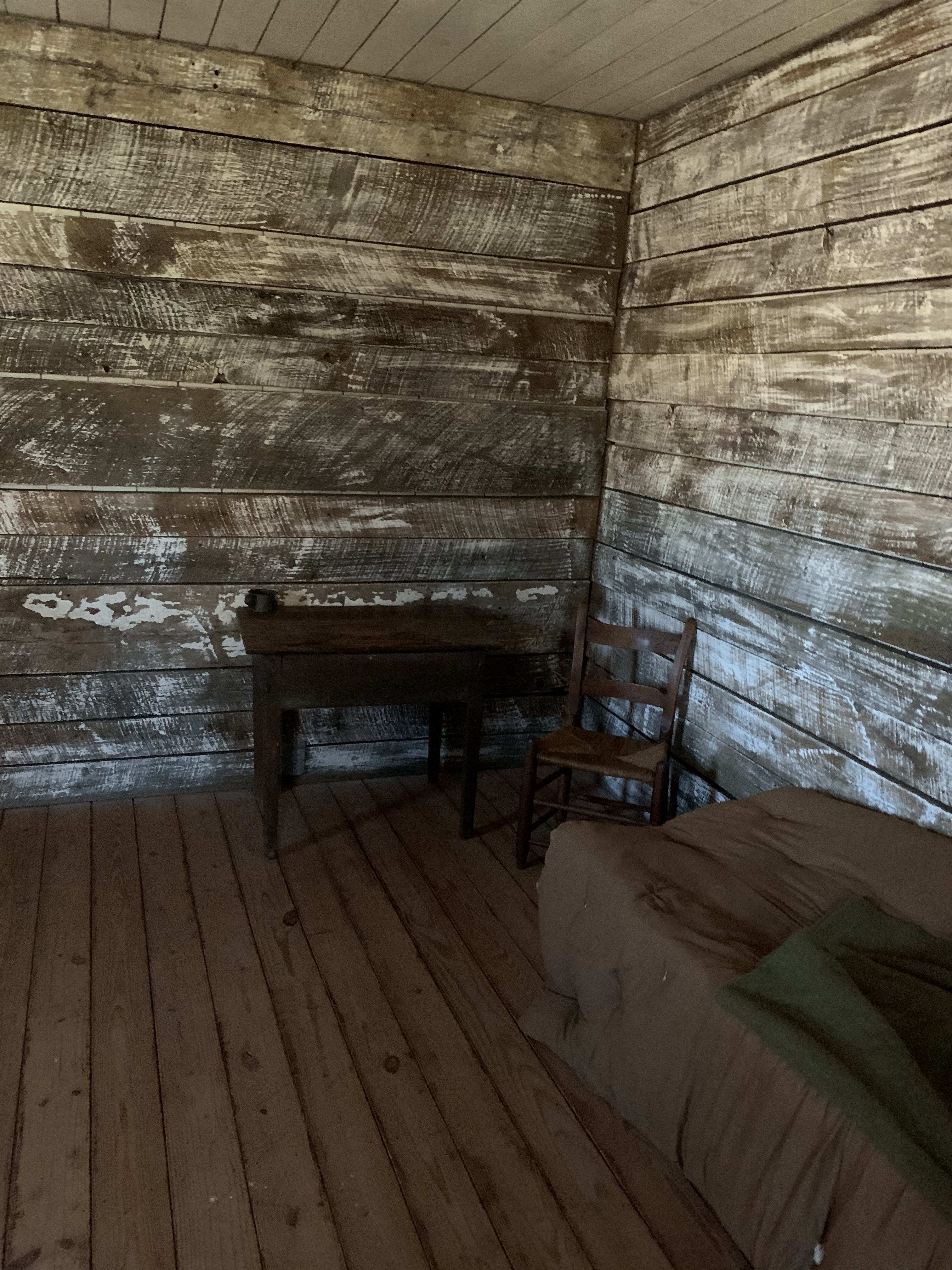
In June of 1866, Justice of the Peace Pickins Carter wrote the warrant for Tom Dula’s arrest from this desk in Elkville, NC. 8 January 2020 For more info, go here: http://www.kronsell.net/the_story_3.htm

No known photographs of Tom Dula exist, but here is one local artist’s rendition of him. Photo by Mom. 8 January 2020 For information about the fake Tom Dula picture, read this article: https://www.statesville.com/news/local/joel-reese-column-who-s-the-soldier-in-the-photo/article_48eb0f0c-4c93-11e8-8455-abac2bbbaf82.html

Through these bars is Tom Dula’s jail cell. 8 January 2020

Looking inside of Tom Dula’s cell… 8 January 2020

Tom Dula’s jail cell… 8 January 2020
Inside of Tom Dula’s jail cell with the guide. Photo by Mom. 8 January 2020
Inside of Tom Dula’s jail cell… 8 January 2020

Tour happening! Photo by Mom. 8 January 2020

Side window inside of Tom Dula’s jail cell… 8 January 2020

Looking out of the front window inside of Tom Dula’s jail cell… 8 January 2020
13 Friday Dec 2019
Tags
Appalachia, county clerk, David F. Smith, Eliza Adkins, F.M. Johnson, Fourteen Mile Creek, genealogy, H.C. Adkins, history, justice of the peace, Laurel Hill District, Lewis Adkins, Lincoln County, Olive F. Adkins, Richard Adkins, Sarah Adkins, Spencer Adkins, West Virginia

Deed Book __, page __, Lincoln County Clerk’s Office, Hamlin, WV.

Deed Book __, page __, Lincoln County Clerk’s Office, Hamlin, WV.
16 Saturday Nov 2019
Posted in Battle of Blair Mountain, Coal, Logan, Matewan
Tags
A.M. Belcher, Appalachia, Charleston, coal, deputy sheriff, Ed Reynolds, Edgar Combs, George Munsey, Harold W. Houston, Harry R. Barnes, history, Jackson Arnold, James Miller, James Swanner, John Chafin, John Gore, justice of the peace, Lee Belcher, Logan, Logan Banner, Mason City, Matewan, Meigs County, Mine Wars, Ohio, Point Pleasant, Pomeroy, Savoy Holt, U.S. Cantley, United Mine Workers of America, W.M. Swanner, Wallace Chafin, Welch, West Virginia, William Chafin
From the Logan Banner of Logan, WV, comes this bit of history about the armed march of 1921:
OFFICERS SAY OHIO MOB THREATENED LIVES
“Let’s Make It a Matewan-Welch Affair,” Yells Citizens of Pomeroy
Officers Say Lives Were Threatened
Another tragic sequel to the miners “armed march” on Logan was narrowly averted at Pomeroy, Ohio, Monday, when a mob of about three hundred persons are said to have threatened the lives of Deputy Sheriffs Wallace Chafin and Lee Belcher, and Mr. Chafin’s son William, who went to Pomeroy to visit his grandfather. The officers were sent to Pomeroy with requisition papers for the removal of Savoy Holt, and U.S. Cantley, who are wanted in Logan on the charge of being accessory before the fact of the killing of George Munsey and John Gore, during the “armed march.”
A statement was given out by Officer Chafin Wednesday, which he described in detail the affair at Pomeroy. Bearing requisition papers for the removal of Holt drawn by the Governor of Ohio and later held up by the agreement of attorneys of both the defense and prosecution till after the trial of James Miller. Officers Chafin and Belcher reported to the sheriffs of Meigs county. They were sent to the Prosecuting Attorney’s office of the county where they were advised that they would have to get other papers for their purpose. They then went before Justice of Peace Harry R. Barnes and swore out a fugitive warrant for the two men wanted. “A crowd of seventy-five or a hundred gathered around the jail. All of the men wore coats and did not seem friendly,” Mr. Chafin said. “We returned to the Prosecuting Attorney’s office, and as I came out there was considerable commotion among the large crowd of men. Persons were being waved back and told to stand aside. These directions were being made by members of the crowd,” Officer Chafin said. Chafin returnerd to the Sheriff’s office and was told that he had been called away, and that he could not see Holt.
“Officer Belcher, myself and my son were directed to the Mayor’s office. We were told that the Mayor had a telegram for us from Governor Donahey, which said that Holt should not be delivered and that if we were ___ to run us out of town and tell us not to return. We did not go to the Mayor’s office, and thought if we were really causing trouble it would be best for us to leave immediately. From the time I arrived in town I noticed that the atmosphere had changed since I was last there. Not an officer could be found anywhere. People gazed out on the streets from their houses in great numbers. And several people were noticed to follow us from the time we arrived in town.”
“When we decided to leave, we hired a taxi cab with the intention of going to Point Pleasant. Again, the crowd which seemed to be growing surrounded the cab, and the driver fled, leaving us standing amidst the crowd in the middle of the street. We heard some one in the crowd say, ‘Let’s make it another Welch or Matewan affair.’ A man who said he was a newspaper reporter began to ask questions as the crowd pushed in against the cab. We were asked if we weren’t Logan county thugs, and if we were not in the gang that opposed the ‘armed march.’ We told them that we were regular Logan county officers and had been serving as Deputy Sheriffs for some time, also that we had been sent there with the proper papers to return Savoy Holt to Logan. They were told that I had been a Deputy for two years and that Belcher had been in office for six years. The crowd dropped back and we got our bags and endeavored to hire another taxi, but evidently the drivers had been given instructions not to drive us. They all refused and we were forced to go to the ferry. The crowd continued to swell and they followed us to the ferry. The ferry boat was on the West Virginia side and we were forced to endure the jeers and threats of the crowd until the boat returned to the Ohio side.
While on the ferry ten or twelve men came in a group and demanded me to get off, saying that I had given a false name. I told them if they wanted me they would have to come and get me. They approached and requested me to show further identifications and I compiled by showing them my Masonic cards.”
“Upon arriving on the West Virginia side I saw several of the same men I had seen in Pomeroy. Another taxi was hired to take us to Point Pleasant. As we started we were hailed. The taxi was stopped and we were told that the driver could not take us. We concluded that we would walk to the next station to avoid trouble. A short distance below the town we were surrounded by about twelve men in automobiles. Heading for the river, and afraid that they would kill my son, we returned to the station at Mason City to wait for a train. While sitting in the station group after group of men came to the doors and men swarmed around. I believe they would have fired on us in the station if there had not been several women sitting near us. The first train to arrive was an east bound train which we took to Parkersburg. The last words we heard from the crowd was from a large man who seemed to act in capacity of spokesman. He yelled, ‘I’m damn sorry boys we did not make this another Welch or Matewan affair.'”
Mr. Chafin reported the affair to Governor Morgan at Charleston Tuesday. He was instructed by the governor that the removal of Holt and Cantley would be affected by the state authorities. It is understood that Colonel Jackson Arnold has been sent to Columbus, Ohio, to get the proper extradition papers for the men’s removal. Cantley is still at large and Holt is being held in the county jail at Pomeroy, where he has been held as a witness in the case of James Miller who was sentenced from two to twenty years for the killing of E. Reynolds and W.M. Swanner. Holt was in the Miller home in Pomeroy at the time of the shooting which took place in Miller’s front yard.
Logan (WV) Banner, 3 August 1923
***
POMEROY, OHIO, IS A REFUGE AFTER CRIMES ARE COMMITTED, SAID
A.M. Belcher, Attorney, Says the Failure of Meigs County to Relinquish Prisoners Is Proof.
MAKES STATEMENT WHILE CALLING ON PROSECUTOR
“The attack on Deputy Sheriffs Wallace Chafin and Lee Belcher, at Pomeroy, Ohio, where they were threatened by a mob when they attempted to return Savoy Holt to West Virginia for trial in connection with the armed march on Logan, in 1921, is only added proof to the claim that the Pomeroy Band is serving as a refuge for various crimes in West Virginia,” said A.M. Belcher, state counsel in the prosecution of the so-called armed march cases.
Mr. Belcher was here Thursday to assist Prosecuting Attorney John Chafin resist an application for a change of venue for Harold W. Houston, chief counsel for District 17, United Mine Workers and Edgar Combs, a member of the mine workers union, for their alleged connection with the murders which grew out of the armed march.
“The refusal of the Meigs county authorities to turn over Holt to the custody of the Logan county sheriffs was in a direct violation of an agreement we had made with attorneys representing the defense,” said Mr. Belcher.
“At the time J.E. Miller was indicted for the murder of James Swanner and Ed Reynolds, Holt was indicted as an accessory to that crime. He was also wanted by the Logan county authorities for his participation in the march, but an agreement was made with Miller’s attorneys that if he were allowed to remain in Meigs county until after the Miller trial that he would immediately be returned to Logan.”
Requisition papers for Holt’s return were honored at the time by Governor Donahey but at the request of Miller’s attorneys West Virginia decided not to insist upon Holt’s immediate return, relying on the defense’s promise that he would be surrendered as soon as the trial was over.
“When Deputies Chafin and Belcher went to Pomeroy Tuesday they had in their possession the requisition papers issued at the time we instituted the original proceedings. They were signed by Governor Donahey on May 15. Neither of the two deputies expected any resistance but to their surprise they were met by a mob of 300 men who not only drove them out of town but pursued them across the river into West Virginia territory.
It would appear that there is something radically wrong with the state’s government that would permit a mob’s action to override its official decisions. The Pomeroy Band has become the refuge of scores of miners who took part in the uprising against Logan county. The entire section apparently is in sympathy with the band of radicals who fostered the march against the citizens of a peaceful county.
The temper of the mob which threatened the two Logan county deputies is seen in the fact that it was only by a miracle that the two officers escaped with their lives. “Let’s make it another Matewan affair” was their battle cry; and the reason that two more West Virginians did not meet death in Pomeroy as did Jim Swanner and Ed Reynolds is due to the courage and coolness of the two officers.
Holt was once in custody of the Logan county officers but was released on bail. Soon after his release he is said to have gone to the headquarters of the United Mine Workers at Charleston and then on the following day left for Pomeroy. It was on the next day that Swanner and Reynolds went to Pomeroy to offer Miller immunity if he would return to Logan county and testify for the state in the armed march cases.
Miller met the two men at the door of his home near Pomeroy and shot both of them to death, though neither of the Logan deputies were armed. Holt, it is said, was in the house at the time of the shooting.
Logan (WV) Banner, 10 August 1923
26 Thursday Sep 2019
Posted in Big Harts Creek, Twelve Pole Creek
Tags
Appalachia, Arnold Perry, Catherine Perry, genealogy, history, Hoover Fork, John McCloud, justice of the peace, Logan County, Pretty Branch, Samuel Dawson, Stephen Marcum, Twelve Pole Creek, Virginia, Wayne County, West Virginia
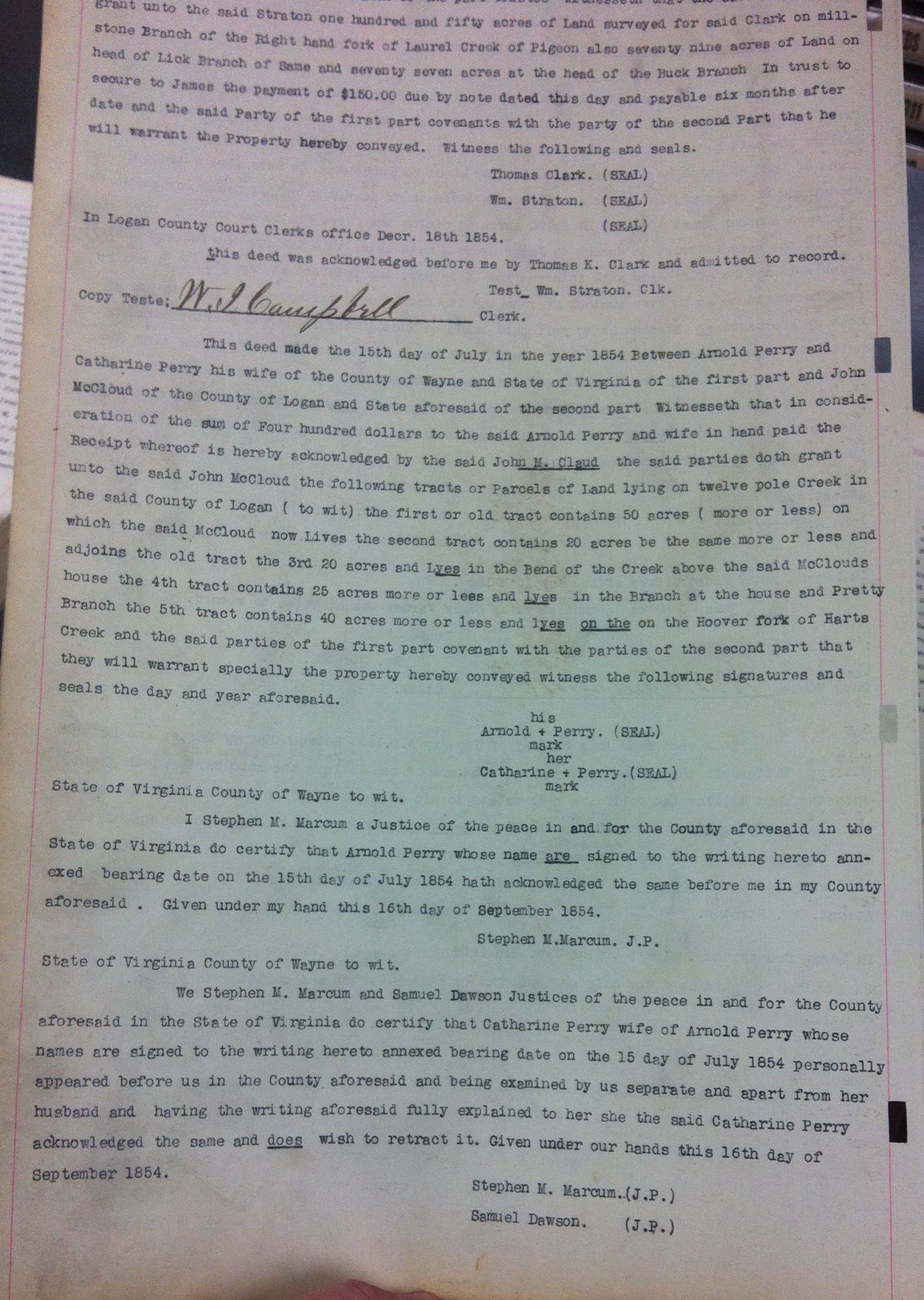
Deed Book C, page ___, Logan County Clerk’s Office, Logan, WV.
19 Thursday Sep 2019
Posted in Big Ugly Creek
Tags
Anderson Barker, Appalachia, Big Ugly Creek, county clerk, genealogy, history, justice of the peace, Levi Collins, Lincoln County, Logan County, Nancy Collins, Ralph Lucas, Virginia, W.I. Campbell, West Virginia, William Smith, William Straton

Deed Book __, page 471, Logan County Clerk’s Office, Logan, WV. This property is located in present-day Lincoln County.

Deed Book __, page 471, Logan County Clerk’s Office, Logan, WV.
15 Wednesday May 2019
Posted in Queens Ridge
Tags
Appalachia, Henry Conley, history, James Browning, John Workman, justice of the peace, Kiahs Creek, Logan County, Lorenzo Dow Hill, Sarah Workman, Spice Branch, Twelve Pole Creek, Vance's Trace Branch, West Virginia, William Smith
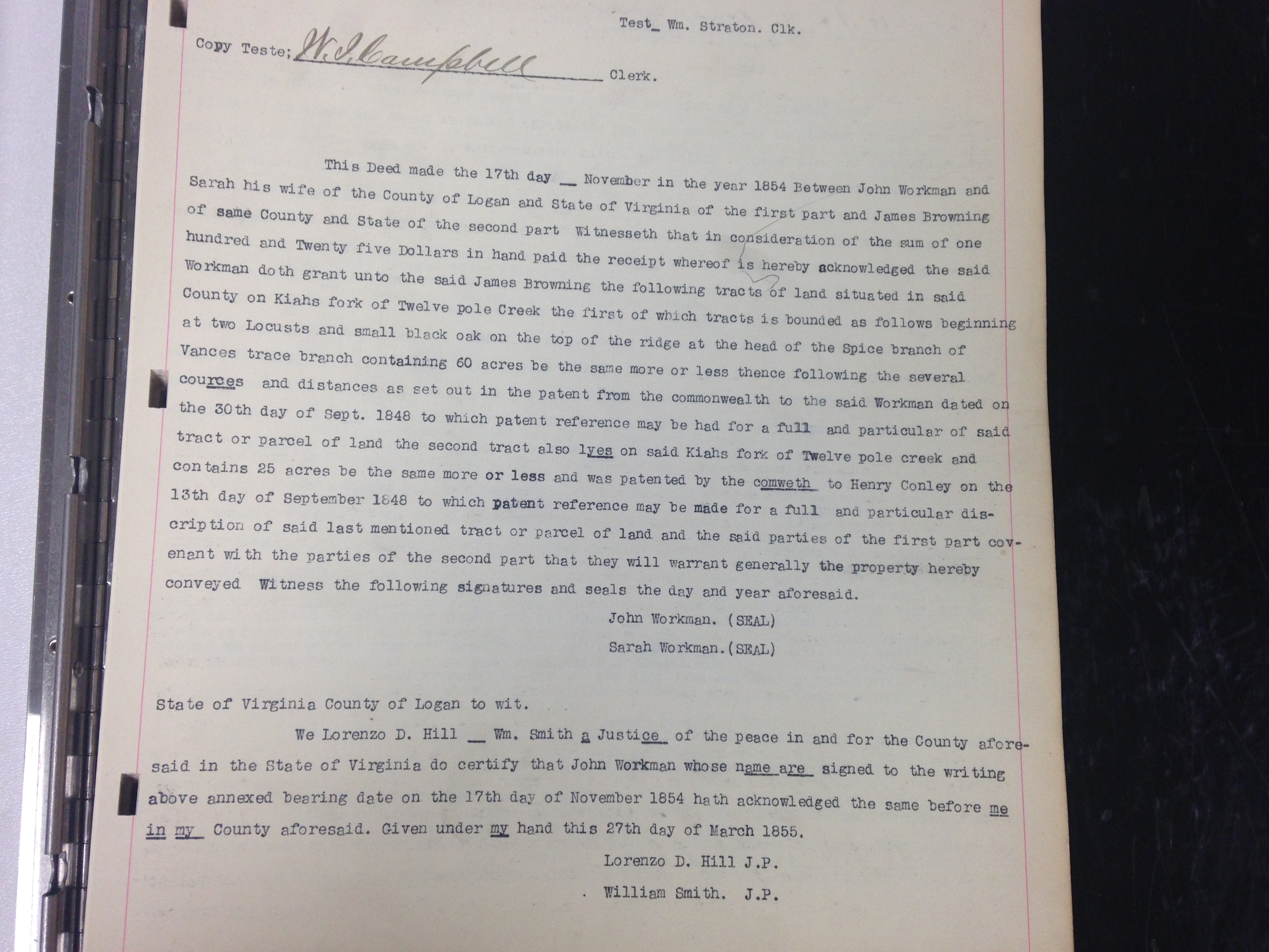
Deed Book C, page ___, Logan County Clerk’s Office, Logan, WV. Today, this land would be located in the vicinity of the Wayne-Lincoln county line.
Writings from my travels and experiences. High and fine literature is wine, and mine is only water; but everybody likes water. Mark Twain
This site is dedicated to the collection, preservation, and promotion of history and culture in Appalachia.
Genealogy and History in North Carolina and Beyond
A site about one of the most beautiful, interesting, tallented, outrageous and colorful personalities of the 20th Century
