• About

Brandon Ray Kirk

~ This site is dedicated to the collection, preservation, and promotion of history and culture in my section of Appalachia.

Brandon Ray Kirk

Category Archives: Gilbert

Map: Southwestern West Virginia (1918-1919)

08 Thursday Dec 2022

Posted by Brandon Ray Kirk in Atenville, Banco, Beech Creek, Big Creek, Big Harts Creek, Big Sandy Valley, Big Ugly Creek, Boone County, Breeden, Chapmanville, Clothier, Cove Gap, Crawley Creek, Dingess, Dunlow, East Lynn, Enslow, Ferrellsburg, Fourteen, Gilbert, Gill, Green Shoal, Guyandotte River, Halcyon, Hamlin, Harts, Holden, Kermit, Kiahsville, Kitchen, Leet, Little Harts Creek, Logan, Man, Matewan, Meador, Midkiff, Pecks Mill, Peter Creek, Queens Ridge, Ranger, Rector, Sand Creek, Spurlockville, Stiltner, Stone Branch, Toney, Twelve Pole Creek, Wayne, West Hamlin, Wewanta, Wharncliffe, Whirlwind, Williamson, Wyoming County, Yantus

≈ Leave a comment

Tags

Appalachia, Big Sandy River, Boone County, Guyandotte River, Hamlin, history, Lincoln County, Logan, Logan County, Madison, map, maps, McDowell County, Mingo County, Pineville, Polk's State Gazetteer and Business Directory, Tug Fork, Twelve Pole Creek, Wayne, Wayne County, Welch, West Virginia, Williamson, Wyoming County

West Virginia State Gazetteer and Business Directory, 1918-1919, published by R.L. Polk and Company.

Regional Place Names

20 Saturday Jun 2020

Posted by Brandon Ray Kirk in Banco, Big Creek, Big Harts Creek, Big Sandy Valley, Boone County, Chapmanville, Crawley Creek, Gilbert, Giles County, Green Shoal, Guyandotte River, Harts, Logan, Matewan, Meador, Twelve Pole Creek, Wharncliffe

≈ Leave a comment

Tags

Appalachia, Beech Creek, Ben Creek, Big Bottom Fork, Big Creek, Big Fork, Bluff Mountain, Bone Lick Bottom, Breckenridge's Fork, Clear Fork, Coal Branch, Coal River, Cow Creek, Crawley Creek, Crooked Creek, Crooked Run, Defeats Branch, Double Camp Branch, Drew's Creek, Elkhorn Branch, Elkhorn River, Flat Top Mountain, Grapevine Creek, Green Shoal Creek, Guyandotte River, Harts Creek, history, Horsepen Creek, Huff's Creek, Indian Creek, Ingrams Branch, Island Creek, Laurel Creek, Laurel Fork, Lick Branch, Lincoln County, Little Coal River, Little Huffs Creek, Logan County, Marsh Fork, Mate Creek, Middle Fork, Mill Creek, Millers Branch, Mingo County, New River, North Fork, Peach Tree, Peter Huffs Creek, Pigeon Creek, Pine Creek, Pond Fork, Rattlesnake Branch, Rock Creek, Rock House Fork, Rum Creek, Sand Lick Fork, Shannon Branch, Skin Fork, Spruce Fork, Trace Fork, Tug Fork, Turtle Creek, Twelve Pole Creek, Virginia, West Fork, West Virginia, Wolf Pen Creek

The following list of regional place names of streams is derived from Surveyors Record Book A at the Logan County Clerk’s Office in Logan, WV. Each document generally lists three dates for the survey; I chose to identify the earliest (Treasury warrant date) and the latest date (survey completion date). The purpose of this list is to document the earliest usage and spelling of a place name in my region. Logan County was extremely large in the 1820s and has since been partitioned to create new counties, so many of these places are not located in Logan County today. This list will be updated periodically.

Beech, a branch of Tug Fork (24 May 1825, 12 October 1825, p. 64)

Ben (26 July 1826, 13 October 1826, p. 89)

Bend of Guyandotte (30 April 1823, 3 March 1831, p. 129)

Big and Clear Fork of Guyandotte River (1 October 1818, 26 June 1826, p. 79)

Big Bottom Fork of Guyandotte (12 February 1823, 25 October 1827, p. 100)

Big Creek (11 December 1817, 25 October 1824, p. 34)

Big Fork of Guyandotte River (18 July 1825, 17 February 1826, p. 73)

Big Island [Logan] (16 February 1825, 17 January 1827, p. 94)

Bluff Mountain (1 October 1818, 21 February 1825, p. 37)

Bone Lick Bottom, New River (19 January 1824, 31 July 1830, p. 123)

Breckenridge’s forks of Cole River (31 January 1825, 27 February 1827, p. 100)

Buffalo (10 February 1825, 6 February 1827, p. 99)

Coal Branch of Guyandotte River (17 December 1824, 31 March 1825, p. 42)

Cow Creek of Island Creek (13 December 1823, 11 October 1826, p. 87-88)

Crawley (10 June 1824, 8 July 1825, p. 47)

Crawleys Creek (16 February 1825, 17 January 1827, p. 95)

Crooked Creek (16 February 1825, 1 April 1825, p. 43-44)

Defeats Branch on Little Huffs Creek (7 October 1830, 27 July 1831, p. 131)

Double Camp Branch of Clear Fork (1 June 1821, 29 December 1825, p. 69)

Drew’s Creek, one of the forks of Peech Tree, a branch of Marsh Fork of Cole River (22 July 1826, 15 October 1828, p. 109)

Elk, a branch of Guyandotte (14 January 1830, 22 November 1830, p. 127)

Elk, a branch of Pigeon (16 February 1825, 18 August 1825, p. 51)

Elkhorn Branch of Tug Fork (30 April 1825, 12 November 1826, p. 93)

Elkhorn River (30 April 1825, 1 November 1825, p. 65)

Flat Top Mountain (22 November 1824, 14 February 1826, p. 72)

Gilbert (14 January 1830, 26 August 1830, p. 121)

Grapevine, a small branch called Grapevine (8 July 1825, 14 October 1825, p. 63)

Green Shoal Creek (15 March 1826, 10 October 1826, p. 86-87)

Harts Creek (17 February 1824, 10 October 1826, p. 87)

Hewetts Creek, a branch of Spruce Fork of Coal River (20 May 1813, 11 April 1825, p. 44)

Horse Creek (10 February 1825, 22 July 1826, p. 92)

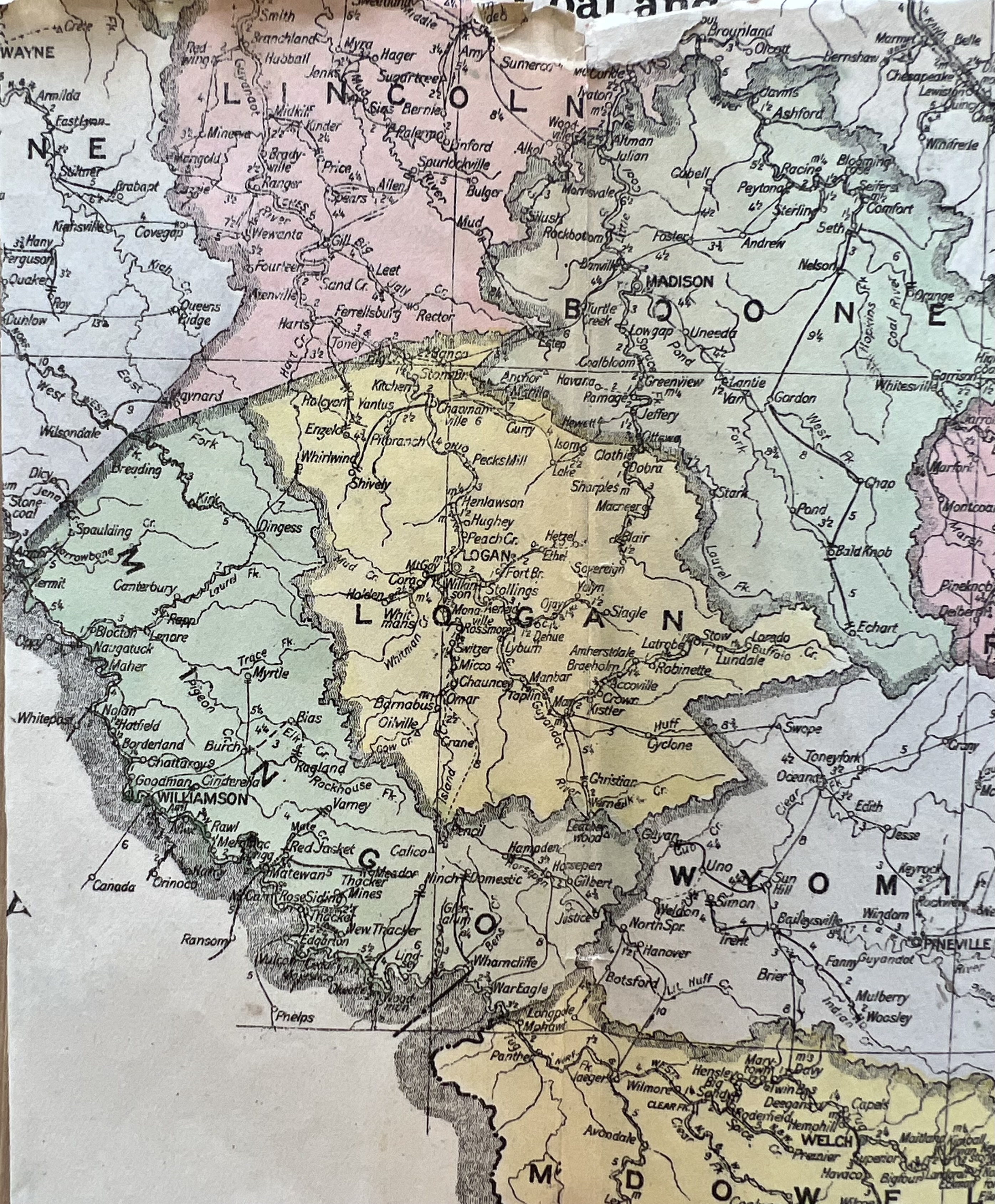
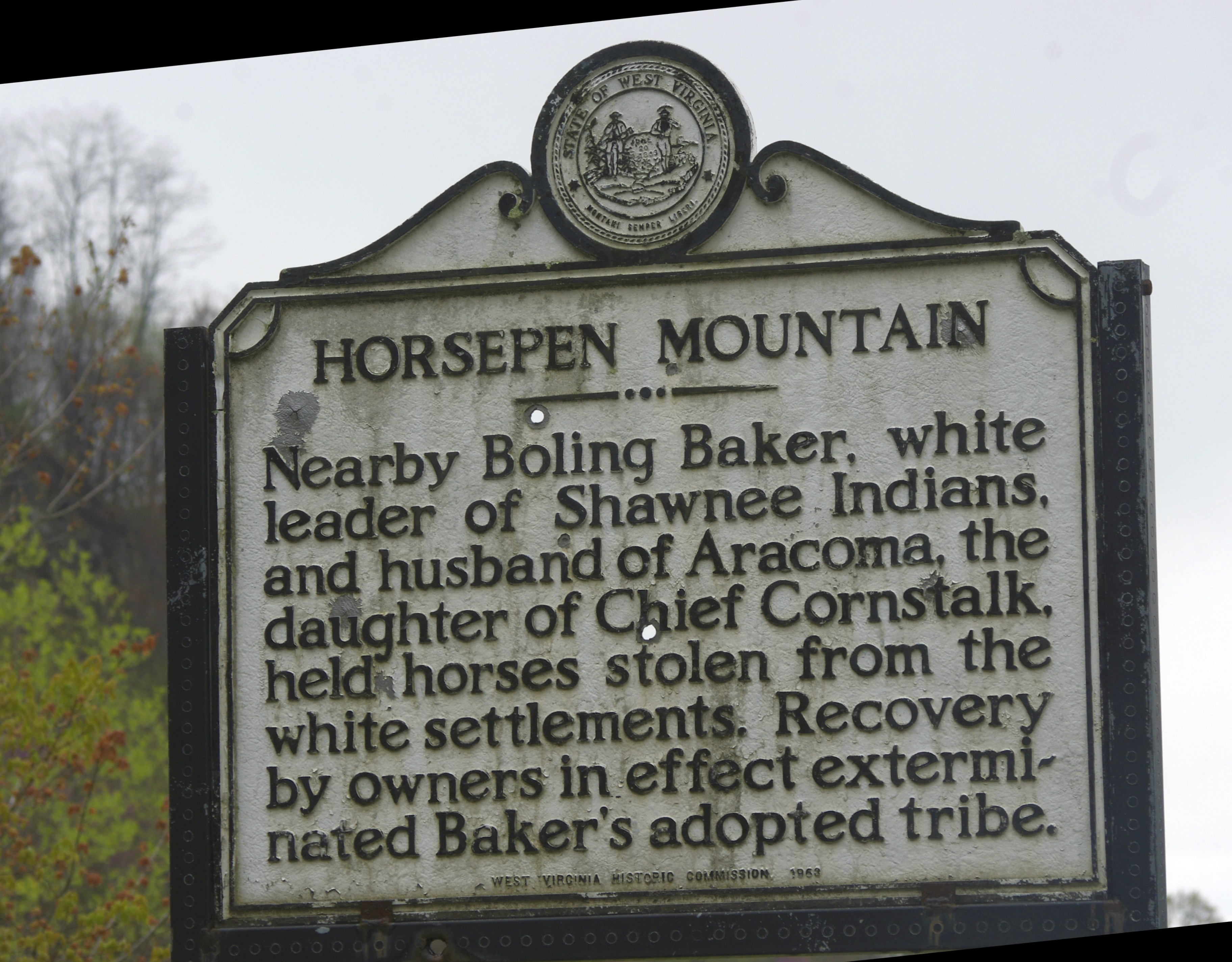
Horsepen Creek, a fork of Gilbert (14 January 1830, 26 August 1830, p. 121)

Huff Creek (11 December 1822, 11 March 1825, p. 40)

Huffs Creek (18 July 1825, 14 March 1828, p. 104-105)

Indian Creek (22 July 1826, 8 February 1827, p. 99)

Ingrams Branch, New River (6 October 1829, 4 December 1829, p. 117)

Island of Guyandotte [Logan] (17 December 1824, 18 January 1827, p. 96)

Island tract [Logan] (4 May 1826, 12 May 1830, p. 120)

Jacks Branch of Clear Fork (6 January 1824, 16 December 1825, p. 66)

Laurel Fork of Guyandotte River (17 February 1824, 27 August 1830, p. 122)

Left Fork of Island Creek (4 February 1817, 28 October 1824, p. 35)

Left Hand Fork of Ben, waters of Tug Fork (13 December 1823, 11 October 1826, p. 88)

Laurel Creek and Crooked Run, New River (10 May 1825, 25 August 1825, p. 56)

Laurel Fork of Pigeon Creek (17 December 1824, 10 October 1826, p. 85)

Laurel Fork of Twelve Pole (3 November 1813, 19 March 1825, p. 40)

Lick Branch (24 May 1825, 10 October 1826, p. 85)

Little Huff’s Creek (4 May 1826, 27 May 1829, p. 116)

Loop of New River (20 February 1821, 26 February 1825, p. 90)

Main Right Hand Fork of Big Creek (24 May 1825, 8 September 1825, p. 54)

Marsh Fork of Cole River (17 February 1823, 9 March 1825, p. 39)

Marshes of Cole River (30 April 1825, 3 February 1830, p. 118)

Mate, a branch of the Tug Fork of Sandy (8 July 1825, 11 October 1825, p. 62)

Mazzel, Little Huffs Creek (12 February 1825, 18 September 1829, p. 116)

Mill Creek, a branch of Guyandotte (18 July 1825, 28 January 1831, p. 128)

Mill Creek of Island Creek (10 January 1823, 29 October 1824, p. 36)

Millers Branch of Tug Fork (4 May 1826, 16 September 1826, p. 81)

North Branch of Big Creek (18 July 1825, 7 September 1825, p. 52-53)

North Fork of Big Creek (4 April 1825, 9 September 1825, p. 54)

Old Island survey [Logan] (22 July 1826, 17 January 1827, p. 95)

Peach Tree, a small branch called the Peach Tree (24 May 1824, 7 October 1825, p. 60)

Pete Huff’s Creek (18 July 1825, 27 August 1830, p. 125)

Peter Huffs Creek (13 December 1823, 12 November 1825, p. 66)

Pigeon Creek (16 February 1825, 15 October 1825, p. 63)

Pine Creek of Island Creek (4 February 1817, 27 October 1824, p. 35)

Pond Fork of Cole River (8 March 1826, 13 November 1828, p. 112-113)

Rock Creek (22 July 1826, 11 August 1828, p. 106)

Rock House Fork of Middle Fork of Island Creek (17 February 1824, 5 October 1825, p. 59)

Rock House Fork of Pigeon (6 February 1825, 22 March 1825, p. 41)

Rum Creek (23 November 1824, 17 July 1828, p. 105)

Sand Lick Fork of Cole River (14 May 1826, 31 January 1827, p. 97)

Shannon branches, Tug Fork (6 December 1828, 2 September 1830, p. 125-126)

Skin Fork of Cole River (12 February 1825, 29 October 1828, p. 111)

Spruce Fork of Coal River (16 February 1825, 22 April 1825, p. 45)

Tonies Fork of Big Cole and Horse Creek (10 February 1825, 22 July 1826, p. 92)

Trace Fork of Big Creek (16 February 1825, 8 September 1825, p. 52)

Tug Fork of Sandy River (10 March 1825, 24 March 1825, p. 42)

Turtle Creek, a branch of Little Coal River (13 December 1824, 12 April 1825, p. 45)

West Fork of Cole River (12 February 1825, 10 November 1828, p. 111-112)

Wolf Pen Creek, branch of New River (10 May 1825, 25 August 1825, p. 56)

Wolf Pen Creek at mouth of Rattlesnake Branch (10 February 1825, 11 January 1826, p. 71)

Gatherings from Gilbert (1894)

17 Tuesday Mar 2020

Posted by Brandon Ray Kirk in Gilbert, Timber

≈ Leave a comment

Tags

Appalachia, crime, farming, genealogy, Gilbert Creek, H.E. Ellis, history, James E. McDonald, James Stimpson, Joseph Bragg, justice of the peace, Logan, Logan County, Logan County Banner, logging, M.A. Hatfield, merchant, Mingo County, timbering, West Virginia, William Johnson

From the Logan County Banner of Logan, WV, come these items about Gilbert in present-day Mingo County, WV, dated 1894:

On yesterday William Johnson lodged James Stimpson and Joseph Bragg in jail here. They were sent on for further trial by Justice M.A. Hatfield, on a charge of breaking into the store of H.E. Ellis, on Gilbert creek. The boys confessed to the offense.

Logan County Banner (Logan, WV), 24 May 1894

***

From Waco, written on July 7, 1894 from Gilbert:

EDITOR BANNER: Farmers are very busy with their crops. Corn is looking as well as could be expected. Oats in most cases are promising.

Two or three applications have been made for our school, but it is thought that Prof. James E. McDonald will teach it.

That log tide which failed to materialize makes it hard on taxpayers and merchants.

Logan County Banner (Logan, WV), 12 July 1894

Boling Baker and Princess Aracoma (1937)

06 Tuesday Nov 2018

Posted by Brandon Ray Kirk in Gilbert, Logan, Native American History, Women's History

≈ 3 Comments

Tags

Abner Vance, Appalachia, Aracoma, Ben Stewart, Ben White, Bluestone River, Boling Baker, Buffalo Creek, Charles Hull, Clear Fork, Dingess Run, Elias Harman, Flat Top Mountain, genealogy, George Berry, Gilbert Creek, Guyandotte River, Henry Clay Ragland, history, Horse Pen Mountain, Huff Creek, Island Creek, James Hensley, James Hines, James White, John Breckinridge, John Carter, John Cook, Joseph Workman, Kentucky, Logan, Logan Banner, Logan County, Logan County Banner, Mallory, Native American History, Native Americans, Oceana, Peter Huff, Rockcastle Creek, Shawnee, West Virginia, William Dingess, William S. Madison

From the Logan Banner of Logan, WV, comes this bit of history concerning Boling Baker and Princess Aracoma, dated March 23, 1937:

IMG_1668

Historical marker on Horse Pen Mountain near Gilbert, Mingo County, WV. 25 April 2015.

Dying Words of Princess Aracoma Related In Story Taken From Banner Files

Though much has been written on the history of Logan county, just as much has been forgotten about its early development.

One of the county’s first historians, Henry Clay Ragland, mayor of the city, church worker and editor of the Logan County Banner, recorded some of the high spots of the development of Logan county in a series of articles which he ran in his newspaper during 1896.

It is from this series of articles that the following story of the early settlement of Logan county is taken.

Records show that a large number of white men first set foot in what is now Logan county in the spring of 1777, when Captain Charles Hull with 20 men pursued a band of marauding Shawnees to the site where Oceana was later built. They lost the trail at Oceana and had to turn back. The Shawnees had raided a white settlement near the falls of New River one spring night and had stolen thirty head of horses. The army captain and his men set out in pursuit but the redskins had too great a start.

Huff Creek was given its name on this expedition in honor of Peter Huff who was killed in a skirmish on the banks of the stream as the men returned home. Huff was buried near the spot where he was killed, which is believed to have been near where the town of Mallory now stands.

Other men on this expedition and who returned to the valley of the Guyandotte later and built homes were John Cook, James Hines, William Dingess and James Hensley.

The first white man really to be identified with what is now Logan county was Boling Baker, a renegade white, but the old-timers would not give him credit for being a white man. They said: “He lived with the Injins and that makes him an Injin.” Baker, however dastardly he was, was indirectly responsible for the settlement of Logan county in 1780-85.

The renegade had one great weakness. A weakness that they hung men for in those days. He was a horse thief. He would take a party of Indians a hundred miles through the mountain passes of Logan county to raid a white settlement in order to steal 20 or 30 horses.

Baker had gone into the business on a large scale. At the head of Gilbert Creek, on Horse Pen Mountain, where the mountain rises abruptly with almost cliff-like sharpness, he had stripped bark from hickory trees and stretched it from tree to tree making a pen in which to keep his stolen stock.

Old settlers of the county who have had the story passed down to them from their great-grandfathers say that the pen was somewhere in the hollow below the road which leads to the fire tower on Horsepen Mountain. It was from this improvised corral of Boling Baker that the mountain was named.

But, back to how Baker was responsible for the settlement of the county.

He left his Indian camps on the Guyan river in the fall of 1780 and visited the white settlements in the Bluestone valley in the Flat Top mountain territory. There he told the settlers a story of how he had been captured by the Indians when he was a young man and had learned their ways. He said he had just escaped from the Shawnee tribe known to be hunting in the Guyandotte valley and was on his way back east to see his father and mother who lived in Boston. Shrewd chap, this Baker!

The settlers were taken in by his story and allowed him to remain with them for several weeks during which time he got the location of all the settlers barns well in mind and after a time departed “back east.”

Soon after the renegade left the Bluestone settlement the whites awoke one rainy morning late in autumn and found every barn empty. The Indians had come with the storm which lashed the valley and had gone without arousing a person. Thirty horses from the settlement went with them.

An expedition headed by Wm. S. Madison and John Breckinridge—son of the Breckinridges who settled much of Kentucky—was made up in a neighboring settlement and set out in pursuit of the thieving Shawnees.

They trailed the party over Flat Top Mountain and southwest to the headwaters of the Guyan River by way of Rockcastle creek and Clear Fork. Trail marks showed that the band had gone down the river, up Gilbert Creek to Baker’s pen and thence over the mountain.

Madison and his 75 men did not follow the Indian trail over the mountain but the redskins probably brought their herd of 50 or 75 horses down Island Creek to the Guyan.

The white expedition chose to follow the Guyan in a hope that they would find the party encamped somewhere along its banks. Scouts had reported that a large tribe of Indians used the Guyan valley as its hunting grounds.

Madison’s party followed the river down to Buffalo Creek—named because the white men found such a large number of buffalo grazing in its bottoms—crossed Rum Creek and pitched camp for a night at the mouth of Dingess Run because “Guyan” Green and John Carter, scouts sent ahead to reconnoiter, had reported finding ten Indian lodges in the canebrakes of an island formed by the joining of a large creek and the Guyan river.

The men rested on their guns for the night and the following morning divided into two parties and attacked the encampment from the front and rear.

In the furious fighting that followed, nine of the thirty Indians in the camp were killed and ten or twelve wounded. Only a few escaped the slaughter of the white men. Among those captured was an old squaw 50 or 60 years old, who by her bearing, was obviously leader of the party. She was wounded but refused to talk.

Near midnight, however, following the massacre of the camp the old squaw felt death creeping upon her and called Madison to her quarters, and told him in broken English the following:

“I am the wife of a pale face who came across the great waters to make war on my people, but came to us and became one of us. A great plague many moons ago carried off my children with a great number of my people, and they lay buried just above the bend in the river. Bury me with them with my face to the setting sun that I may see my people in their march to the happy hunting ground. For your kindness I warn you to make haste in returning to your homes, for my people are still powerful, and will return to avenge my death.”

The proud princess died before morning and the white men buried her “near the bend in the river.” The Indian captives were all killed.

Four days later the men returned to the valley of the Bluestone.

Among those who helped Wm. S. Madison rout the Shawnees and who vowed to possess the valley of the Guyandotte for themselves and their children were George Booth, George Berry, Elias Harman, Ben Stewart, Abner Vance, Joseph Workman, Ben White and James White. All these names are familiar in the county today.

After the Indians were pushed to the west, surveyors allotted the land to the first settlers who had dared, with Madison, to come into the wilderness of the Guyandotte and open it up for the white man.

Madison owned several thousand acres of land on Island Creek, Gilbert Creek and Dingess Run. Other fighters were given like parcels of land.

Source: Logan (WV) Banner, 23 March 1937

Origin of Place Names in Logan County, WV (1937)

12 Friday Oct 2018

Posted by Brandon Ray Kirk in Chapmanville, Coal, Gilbert, Guyandotte River, Logan, Man, Native American History

≈ Leave a comment

Tags

Appalachia, Aracoma, Barnabus, Barnabus Curry, Boling Baker, Buffalo Creek, Cham, Chapmanville, Chauncey, Chauncey Browning, coal, Crystal Block, Curry, D.E. Hue, Dehue, Dingess Run, Edward O'Toole, Gilbert Creek, Guyandotte River, history, Horse Pen Mountain, Huff Creek, Island Creek, Jim Gilbert, Litz-Smith Coal Company, Logan Banner, Logan County, Main Island Creek Coal Company, Mallory, Micco, Mountain View Inn, Native American History, Native Americans, Omar, Omar Cole, Peter Huff, Rum Creek, Sarah Ann, Sarah Ann O'Toole, Stirrat, Twisted Gun Lick, West Virginia, William Dingess, William S. Madison

From the Logan Banner of Logan, WV, comes this bit of history about Logan County place names:

Naming of Logan County Towns and Creeks Related By Logan Banner Reporter

While the first white settlers who entered the county near the middle of the 18th century had to have names for the creeks and runs in order to locate their homes, the children of these first settlers had to have names for each large settlement in order to have their mail delivered to them. Both groups used interesting methods of naming the landmarks.

Early Indian fighters who had contact with Boling Baker and his horse-thieving found little trouble naming the mountain which rises behind Mountain View Inn at the head of Island Creek. Because of the renegade’s custom of using one of the steep hollows for a corral, Captain William S. Madison, an early pioneer, named the mountain Horse Pen. Likewise, Gilbert Creek was named for Jim Gilbert, an Indian scout, who was killed in an Indian skirmish on that tributary of the Guyandotte. Near the place where he was killed there is an old salt lick which is named “Twisted Gun Lick.” The story is told that Gilbert, before he died, hit his gun barrel against a tree to keep the Indians from using it on his comrades. His friends, coming to the lick several hours later, found Gilbert scalped and the twisted firearm lying nearby.

Huff Creek was similarly named for a Peter Huff, whose scouting party was ambushed by a roving band of redskins and Huff was killed in the ensuing battle. They buried Huff on the banks of the creek near the present town of Mallory.

Buffalo Creek, however, received its name in an entirely different manner. The first settlers who hunted in the valley of the Guyandotte found buffalo herds so plentiful on this creek that they called it Buffalo Creek.

Dingess Run was named for a pioneer family of Dingesses which settled in its broad bottoms. William Dingess was the patriarchal head of the family and his children named the run in memory of him.

Island Creek received its name from the Indians who were awed by the beauty of a large creek flowing into the Guyandotte with such force as to cut an entirely separate bed, thus forming an island in the middle of the river. Old timers say that in the early days of the county Island Creek entered the Guyan river at the upper limits of Aracoma. Only during flood time did the creek meet the river at its present point.

As for the towns which have sprung up in the county since coal became king, many were named for prominent people living in them at one time or another or for pioneer families who lived in the towns when the coal companies first came in.

A unique method was used, however, in naming Micco. It received its name from the first letters of the Main Island Creek Coal Co., which formerly operated the mines there.

Omar was named for Omar Cole who was closely associated with the development of the town. The Cole family held, and still holds, extensive mining leases in the vicinity of that mining town.

Sarah Ann acquired its name from the wife of Colonel Edward O’Toole, who was manager of the coal company when the town applied to the government for a post office. The town is generally known as Crystal Block.

Barnabus received its name from Barnabus Curry, a pioneer settler whose home was near the town.

Stirrat was named for Colonel Stirrat, who was manager of the Main Island Creek Coal Company at one time.

Chauncey was named for Chauncey Browning, well-known son of a pioneer family who owned much of the land near that town. For many years the town of Chauncey was not large enough to be made a post office, but after the Litz-Smith Coal Company opened its mines there the town grew to proportions large enough to warrant a post office.

Dehue was given its name in honor of D.E. Hue, the first superintendent who operated the mines there.

Cham, a small place about two and one-half miles above Dehue, got its name from a Chambers family who lived on Rum Creek.

Chapmanville was named for the Chapmans, Curry for the Curry family and Aracoma for the famous Indian princess.

Source: Logan (WV) Banner, 25 March 1937

Man High School Girls’ Basketball Team (1928)

13 Thursday Sep 2018

Posted by Brandon Ray Kirk in Boone County, Gilbert, Huntington, Logan, Man, Sports, Women's History, Wyoming County

≈ Leave a comment

Tags

Appalachia, basketball, Burch High School, Ceredo-Kenova High School, Cincinnati, Clothier Independent High School, genealogy, Gilbert High School, history, Huntington High School, Indianapolis, Logan Banner, Logan County, Logan High School, Madison High School, Man High School, Oceana High School, Sports, West Virginia, Wichita

Man HS Girls Basketball Photo LB 03.06.1928 3

Logan (WV) Banner, 6 March 1928.

Man HS Girls Basketball Photo LB 03.06.1928 2

Logan (WV) Banner, 6 March 1928.

Man HS Girls Basketball Photo LB 03.06.1928 4

Logan (WV) Banner, 6 March 1928.

Man HS Girls Basketball Team Goes to Kansas LB 03.27.1928 1

Logan (WV) Banner, 27 March 1928.

Guyandotte River Navigation (1927)

28 Monday May 2018

Posted by Brandon Ray Kirk in Gilbert, Guyandotte River, Logan

≈ Leave a comment

Tags

Appalachia, Bernard Call, Boy Scouts, Gilbert, Guyandotte River, history, Logan, Logan Banner, Logan County, Mingo County, Tom Johnson, West Virginia

Guyan River Navigation LB 08.23.1927.JPG

Logan (WV) Banner, 23 August 1927.

Recollections of A. Peterson Christian of Simon, WV (c.1943)

28 Monday May 2018

Posted by Brandon Ray Kirk in Big Creek, Gilbert, Guyandotte River, Logan, Timber, Wyoming County

≈ Leave a comment

Tags

Appalachia, Betty Shoals, Big Branch Shoal, Big Creek, Big Cub Creek, Blackburn Mullins, Burrell Morgan, Byron Christian, Chapman Browning, Charley Toler, Copperas Fork, Ed Robertson, Eli Blankenship, Eli Morgan, Elk Creek, Ellis Toler, Epson Justice, Fred B. Lambert, Fred B. Lambert Papers, G. Pendleton Goode, genealogy, Gilbert, Guyandotte, Guyandotte River, H.C. Avis, Hickory Shute, history, Hugh Toney, Humphrey Cline, Huntington, James A. Nighbert, James Pine Christian, Jesse Belcher, John Buchanan, John Justice, justice of the peace, Lane Blankenship, Lark Justice, Leatherwood Shoal, Lewis Mitchell, Little Kanawha Lumber Company, Logan County, Logan Court House, logging, Marshall University, Mingo County, Morrow Library, Paren Christian, Peter Cline Jr., Peter Cline Sr., Peterson Christian, Pineville, pushboats, rafting, Raleigh County, Roughs of Guyan, Salt River Shute, Sanford Morgan, Simon, Spice Creek, Staffords Mill, West Virginia, White Oak Cliff, Wyatt Toler, Wyoming County

Recollections of A. Peterson Christian of Simon, WV, provided by G. Pendleton Goode of Pineville, WV, January 1, 1944:

I was born on Spice Creek, Logan Co., now Mingo County, West Va. on Oct. 12, 1857 — Now 86 years of age, Son of Rev. Byron Christian, and grandson of James Pine Christian (1800-1892), one of the justices who organized Logan County in 1824.

About 1867, people began what we called saw-logging. Dr. Warren from Big Creek brought the first six yoke ox team to our neighborhood, used them two years and then sold them to Chapman Browning who lived on Spice Creek. There sprang up among us, what we called timber merchants, among those were Paren Christian, Chapman Browning, Col. John Buchanan, H.C. Avis, Blackburn Mullins and Epson Justice and many others. Besides hauling and rafting their own timber, they would buy rafts of other parties and run them to Logan Court House and sell others to John and Lark Justice and afterwards to Ed Robertson and James Nighbert.

I entered the logging business in 1875, on a small scale. Lewis Mitchell and I bought some timber and made up a raft, and when the river reached rafting stage, Brother Mont Lewis and I started down the river with the raft which swung across the head of “Island 16,” but when the big July 12th freshet came it swept our raft away and we lost it. My next adventure in logging was in the spring of 1876, when Mont and I bought some timber in the bluff opposite the mouth of Elk Creek and with some loose logs in “Island 16,” we made up two rafts, but there was no rafting stage that summer, but when the ice went out the next winter, both rafts went with it and we lost them also.

Rafting down Guyandotte River from Reedy to Logan Court house was a great art during the 1870s and 80s. There were different opinions about the bad places along the stream. People at Logan Court house thought that the river from Spice down was real bad; but the river men around Spice did not mind running from there down, but said that up Copperas Fork, the Betty Shoals, Staffords Mill, and the White Oak Cliff was too bad for anybody to run a raft. The river men around about Gilbert said that the river from there down was a little rough but they didn’t mind it, but from Epson Justice’s up to Reedy was so rough that no person had any business trying it. But when you came up to Big Cub, Long Branch and Reedy and talked with the old pilots, such as Jesse Belcher, Lane Blankenship, Peter Cline Jr., Humphrey Cline and Peter Cline Sr. and numerous other persons such as oar carriers and seconds they would say something like this, “Well, the river for a few miles is pretty rough, especially at Wyatt Toler’s mill dam, the Fall Rock, near Charley Toler’s mill dam, the Hickory Shute, the Leatherwood Shoal, the Big Branch Shoal and the Salt River Shute, but if a man has good judgment about the drain and the water he will have but little trouble.” So you see all depends on whom you are talking to as to where the rough is on the Guyandotte River. The only way to find this out is to go through on a raft yourself.

I remember very well the thrill I got the first time I went through the “Roughs” on a raft. I got on at the mouth of Big Cub Creek; in a few minutes we were at the upper end of Leatherwood Shoal. We worked the raft to the proper position in the hole of water just above the shoal. We could look along the top of the water to the upper end of the shoal but there was such a fall there we could see the water until we dropped over the upper end of the shoal. The bow of the raft struck a wave and the water flew over our heads. I was carrying the oar and held the stern down on the raft while my second held my clothes to keep the oar from throwing me off. From there on to the lower end of the shoals (about ¼ mile) as soon as the raft would rise on one wave, it would plunge into another until we got through the shoal. From that time (1876), I followed running from Reedy to Guyandotte until about 1890.

It took 4 men to run a raft from Reedy or Cub to Spice. Then 2 men could take it from there to Logan C.H. Then we would latch two of those rafts together and 2 men would take those rafts through to Guyandotte.

In 1889, the Little Kanawha Lumber Co. came to Wyoming County and began logging on a big scale. The winter was warm and rainy. All goods and supplies were hauled from Prince Station on the C. and O. Ry. The roads through Raleigh were so muddy that a four-horse team could pull only 1000 or 1200 pounds, so in April Alec, Henry Blankenship and I made a push boat 50 feet long and 6 feet wide and 18 inches deep. We landed it at the mouth of Reedy Creek and started to Guyandotte with five men. I had about $95.00 in money, and the men from here to Elk sent money by me to buy flour. When I left Elk, I had about $260.00. Among the men that sent money by me to buy flour were Burrell Morgan, Ellis Toler, Eli Blankenship, Eli Morgan, Sanford Morgan and Chapman Browning and the only one alive now is Burrell Morgan. We reached Guyandotte the 3d day, where I bought 45 lbs of flour, 300 lbs of bacon and a lot of other things and after laying over at Capt. Toney’s for 2 days on account of high water, we arrived at the mouth of Spice Creek in 8 days from Guyandotte. I received $125 per 100 lbs. freight which gave me a nice profit for my trip. At that time and long before the people of Logan brought their goods up on push boats.”

Source: Fred B. Lambert Papers, Special Collections Department, Morrow Library, Marshall University, Huntington, WV.

Island Creek Roads (1927)

19 Thursday Apr 2018

Posted by Brandon Ray Kirk in Boone County, Gilbert, Hamlin, Huntington, Logan, Ranger, West Hamlin, Wharncliffe

≈ Leave a comment

Tags

Appalachia, Beech Creek, Ben Creek, Bluefield, Bluestone River, Bob Browning, Boone County, Bramwell, Cabell County, Charleston, Coal Valley News, Commissioner of Agriculture, Crum, Davy, Devil Anse Hatfield, farming, Gilbert, Gilbert Creek, ginseng, Griffithsville, Guyandotte River, Hamlin, history, Horsepen Creek, Huntington, Iaeger, Island Creek, John W. Smith, Kanawha River, Lincoln County, Logan, Logan Banner, Logan County, M.L. Jones, Mate Creek, Pigeon Creek, Ranger, Route 10, Route 2, Route 3, Sarepta Workman, Tug Fork, Twelve Pole Creek, Wayne, Welch, West Hamlin, West Virginia, West Virginia by Rail and Trail, West Virginia Hills, Williamson

From the Logan Banner of Logan, WV, comes this bit of history about Route 3 dated October 14, 1927:

“Changes Can Be Noted” In Island Creek Hills

Madison Editor Waxes Interesting on Old Times and Primitive Conditions–Surfaced Highways Mark the Paths Through Woodland That Were Traveled a Generation Ago.

An article of special interest to Logan folk is here reproduced from the Coal Valley News (Madison) of which M.L. Jones is editor. In a reminiscent mood he tells of road conditions and other conditions that prevailed hereabouts a generation ago. Exceptions might be taken to one or two statements, but the whole article is interesting indeed and informative.

It is considered appropriate that West Virginians should sing the “West Virginia Hills,” and year after year the teachers in their institution disturb their neighbors with this song, while “Tears of regret will intrusively swell.” There is some romance and merit in the song; but it strikes us that it is about time for a revision of this line.

“But no changes can be noticed in the West Virginia Hills.”

To prove our point we quote from memory.

For some years after 1882, there lived in the extreme head of the left fork of Island Creek, or Main Island Creek, a man named Bob Browning. It was 18 miles from Logan. The house was a two-room log cabin, surrounded by palings; and the valley was so narrow that it was difficult to find enough level ground for a garden. Apple trees and peach trees were scattered over a few acres of cleared mountain side. The family subsisted by a little farming, a little hunting and much ginsenging.

This place was between two low mountain gaps. A dim road, usable for wagons in dry weather, led down the creek to Logan, and forked at Browning’s house. One fork led east over one gap to Horsepen and Gilbert of Guyan; the other went west over the other gap to Pigeon creek, and by more or less roundabout ways connected with Ben Creek, Beech Creek, Mate Creek and Pigeon Creek, all of Tug river. Hence, it was a possible road route.

The nearest house down Island creek and on Horsepen creek was two miles; and on Pigeon creek about three-fourths of a mile. A wagon, lightly loaded, passed here on the average six times a year. Horsemen may have averaged one a day, though often a whole week passed without a traveler. It was simply a log shack in the head of the hollow, four miles from a school, ten miles from a store, without anything “which exalts and embellishes civilized life,” and so very remote from the haunts of men that when “Devil” Anse Hatfield and his followers concluded to surrender Tug river to Frank Phillips and the McCoys, they picked their “last stand” on Island creek, four miles below the spot we have been talking about.

Now, in the close of 1927, can “changes be noticed?” We have not been there for over 30 years. But we recently received a present from John W. Smith, commissioner of agriculture , Charleston, W.Va., entitled “West Virginia by Rail and Trail,” containing 22 maps and 174 pictures reproduced from photographs of different parts of the state, and for which we sincerely thank whoever got our name on Mr. Smith’s mailing list.

From this book we learn that when we laboriously trudged through the Horsepen gap or the Pigeon gap, from 45 to 35 years ago, we failed to foresee that within on generation men would pick those two gaps, within less than a miles of each other, as a route for one of West Virginia’s leading roads; and not only for one, but for two, of West Virginia’s leading roads. As we will explain:

Route 3, connects Huntington, Wayne, Crum, Williamson, Gilbert, Iaeger, Davy, Welch, Bramwell, and Bluefield. From Huntington to Wayne and about 15 miles above Wayne, it is mostly on the waters of Twelve Pole creek. It then bears west to Tug river and follows it from Crum to Williamson, about 25 miles. It then bears east to Pigeon Creek, which it follows to the spot we are writing about, in the head of Island creek, some 20 miles. It then goes through the two gaps and down Horsepen creek to Gilbert, on Guyan; up Guyan and Little Huff’s creek, of Guyan, and across the mountain to Iaeger, on Tug river. It then follows up Tug, by Welch, to the head of Elkhorn and then on the waters of Bluestone to Bluefield.

In all, Route 3 is in seven counties, though less than a mile of it is in Logan county, in the head of Island creek. It is graded all the way about 60 percent of it is hard surfaced, including about 25 miles at and near the Bob Browning place. Thus Bob, if alive, can ride on a hard surfaced road from his old home almost to Williamson, one way, and to Gilbert on Guyan the other way; and he could continue south by graded road, until he strikes hard surface again. The last fifty miles next to Bluefield is all hard surfaced, also the lower 25 miles next to Huntington.

But this is not the only big state route hitting this “head of the hollow.”

Route 10 runs from Huntington to the very same spot, a distance of 100 miles, through Cabell, Lincoln and Logan, and is all on Guyan or its tributaries. It is paved, or hard surfaced, from Huntington to West Hamlin, on Guyan where the Hamlin-Griffithsville hard-surfaced road turns off. It is also marked paved for seven miles north of Logan and twelve miles up Island creek. This leaves six miles up by the “Devil” Anse Hatfield place to the Bob Browning place to pave, and it is marked, “paved road under construction.” The only drawback to No. 10 is that from West Hamlin to Ranger is a patch where the grading is not yet satisfactory. Doubtless, within three years both 3 and 10 will be hard surfaced all the way. Even now, from the Browning place, the people can take their choice between an evening’s entertainment in Logan or Williamson.

But that is not all yet. The chances are heavy that there will never be but one hard surfaced road from Logan to Williamson. There will always be a heavy travel from Charleston to Williamson. It will be by our No. 2 to Logan; by No. 10 to the Browning place; and by No. 3 to Williamson. Within a few months it will all be hard surfaced.

From all this we conclude.

First; that we let a good chance slip when we failed to buy a half acre of land where No. 10 joints No. 3 for a hotel and filling station. We could have multiplied our investment by one thousand. But so far as we could see that spot was fit only to hold and the rest of the Earth’s surface together, and to get away from as rapidly as possible.

Second; that “changes can be noticed in the West Virginia Hills.”

We might add that thousands can remember crossing the Kanawha at Charleston on the ferry, because there was no bridge; and few, if any, three-story homes. The writer hereof did his first plowing with a two-horse turning plow in the center of what is now Huntington. It was a cornfield then. It is a fashionable residence district now. He boarded at an isolated log house on a hill back of the Huntington bottom, where now are miles of mansions on paved streets. Even in and about Madison and all over Boone county, it is hard for people to visualize how things looked a short ten years ago. Mrs. Sarepta Workman, on her recent visit to her old…

George T. Swain and the Revenuers (1927)

03 Saturday Mar 2018

Posted by Brandon Ray Kirk in Gilbert, Logan

≈ Leave a comment

Tags

Appalachia, crime, Fred Russell, genealogy, George T. Swain, history, Jim Reynolds, Logan County, Mingo County, moonshine, moonshining, revenuers, Verner, West Virginia

From the Logan Banner of Logan, WV, comes this story of a revenuer raid written by county historian George T. Swain and published on 27 May 1927:

NEWSPAPERMAN FINDS EXCITEMENT AS COMPANION OF OFFICERS WHO RAID COVES WHERE MOONSHINERS ABOUND

Last Friday was a hectic day in the life of a certain newspaperman. Being invited by members of the state police and a deputy marshal to accompany them on a moonshine raid this reporter was naturally quite interested in viewing a moonshine still in operation. He had never seen an apparatus in action, having been all his life on the consuming end and not the manufacturing end of the industry.

However, we were assured by the officers that more than likely we could see a still in operation and have the added thrill of viewing them making a capture of the operators. So we were up bright and early as Popys would say and were off at record speed for a journey of many miles to Verner, where we left our car and headed for the mountain coves.

Nearing the nest of the moonshiners the party divided. Sergeant Jay Rowe elected to take one hollow and dispatched Deputy Marshall J.T. Reynolds and Trooper Wilson up another while he sent Trooper Fred Russell and ye reporter up the third one. All were armed with pistols and high-powered rifles save the reporter who was armed with a kodak.

We had been warned should we meet with the moonshiners and a battle was to ensue to get behind a tree or fall to the ground. We tucked this advice away in our little brain for future use. The matter of locating moonshine stills, we learned, is pretty much a matter of deduction.

The officers would get to the middle of a small branch and follow the stream ahead. Invariably right at the head of the stream they will find a moonshine still if there is any in the vicinity. Up the mountain side we clambered with a thicket as dense as a hedge on every side. Yet up and up we climbed while ye reporter’s legs grew weary and his breath came short and fast.

All at once Trooper Russell halted and we prepared for a nose dive. Pointing up and right ahead he said: “There she is” and sure enough there was a still still smoking while the embers were growing cold beneath it. We climbed up on the little mountain bench and there we found all necessary ingredients for the manufacture of the fluid that keeps the undertakers in business.

We sat there and patiently waited for the other officers to “close in” and they were not long in coming. Had the operators been there they would have been captured for we had it well surrounded by they evidently had left it only a few short hours before. We got out pictures and was informed that Trooper C. Wilson and Uncle Jim Reynolds had found another.

Everything being finished the officers started their work of “mopping up.” Everything was broken into smithereens and the old gasoline tank that served as the still was rolled to one side where she could be pumped full of holes. Ye reporter’s attention was diverted for the moment and Trooper Wilson raised his rifle and fired a hole through the tank. Thinking it was the moonshiners opening fire ye reporter kissed mother Earth one resounding smack and she sure tasted sweet. Already scared to death that little previous advice was well followed.

We mopped up on three stills and 200 gallons of mash and started for another when we found Mingo county officers had beat us to it. A tired and weary newspaper man arrived in Logan and is just now getting the kinks out of his legs from the weary climb. He prefers to do his hunting trying to find the characters on the keyboard of an Underwood, rather than climbing mountains while half scared to death trying to find moonshine stills set up ready for action. The mash nearby was enough to satisfy our thirst for strong drink. The concoction would surely kill a hog but men will continue to drink it.

Johnson Hatfield (1890-1900)

28 Tuesday Nov 2017

Posted by Brandon Ray Kirk in Culture of Honor, Gilbert, Hatfield-McCoy Feud, Matewan, Pikeville

≈ Leave a comment

Tags

Alifair McCoy, Appalachia, Beech Creek, Calvin McCoy, Chafinsville, crime, Dan Cunningham, Devil Anse Hatfield, Dollie Hatfield, feud, feuds, Floyd County, Frank Phillips, genealogy, George Hatfield, Gilbert Creek, Greek Milstead, Hatfield-McCoy Feud, Henry Clay Ragland, history, Huntington Advertiser, Johnse Hatfield, Johnson Hatfield, Kentucky, Logan County, Logan County Banner, Matewan, Mingo County, murder, Nancy Hatfield, Norfolk and Western Railroad, Oakland Hotel, Pikeville, Portsmouth Blade, Prestonsburg, Southern West Virginian, T.C. Whited, Thomas H. Harvey, true crime, Vanceville, West Virginia

From the Logan County Banner of Logan, WV, and the Huntington Advertiser of Huntington, WV, come the following items relating to Johnson Hatfield:

Johnson Hatfield Notice of Deposition LCB 02.20.1890.JPG

Logan County Banner (Logan, WV), 20 February 1890. Also appeared on 13 March 1890.

***

Johnson Hatfield v. N&W RR LCB 07.30.1891.JPG

Logan County Banner (Logan, WV), 30 July 1891.

***

We are glad to see that Johnson Hatfield, who has been confined to his room for the last ___ weeks, is able to be on the street again.

Source: Logan County Banner (Logan, WV), 2 March 1893.

***

There was an unfortunate difficulty at Matewan on Sunday last in which Mr. Johnson Hatfield was severely wounded through the hand. His son had become involved with an officer which drew his father into the trouble.

Source: Southern West Virginian via the Logan County Banner (Logan, WV), 1 January 1896.

***

Johnson Hatfield, accompanied by his daughter, Miss Dollie, left on Monday last for a visit to friends and relatives in Mingo county.

Source: Logan County Banner (Logan, WV), 23 January 1897.

***

Johnson Hatfield and daughter, Miss Dollie, have returned from a visit to friends on Sandy.

Source: Logan County Banner (Logan, WV), 6 February 1897.

***

Johnson Hatfield, the genial proprietor of the Oakland Hotel, is visiting friends at Pikeville, Kentucky.

Source: Logan County Banner (Logan, WV), 28 August 1897.

***

Johnson Hatfield has returned from a visit to Pikeville, Ky.

Source: Logan County Banner (Logan, WV), 9 October 1897.

***

Johnson Hatfield is at Williamson this week.

Source: Logan County Banner (Logan, WV), 23 October 1897.

***

The many friends of Mrs. Johnson Hatfield will regret to learn of her serious illness. She has a very bad attack of rheumatism.

Logan County Banner (Logan, WV), 13 November 1897.

***

Johnson Hatfield and wife, of Mingo, passed through here [Chafinsville] last Sunday en route for Vanceville, where they will make their future home.

Source: Logan County Banner (Logan, WV), 21 April 1898.

***

HATFIELD KIDNAPPED.

TAKEN TO KENTUCKY ON A SERIOUS CHARGE–NOW IN JAIL.

Johnson Hatfield was arrested yesterday and taken to Pikesville, Kentucky, and lodged in jail on a charge of being an accomplice in the murder of Alifair McCoy on New Years night about nine years ago. This murder was committed during the feud of the Hatfields and McCoys.

Source: Huntington (WV) Advertiser, 20 July 1898.

***

Johns Hatfield Captured LCB 07.21.1898

Logan County Banner (Logan, WV), 21 July 1898.

***

Johnson Hatfield Interview LCB 8.11.1898.JPG

Logan County Banner (Logan, WV), 11 August 1898.

***

Johnson Hatfield LCB 10.20.1898.JPG

Logan County Banner (Logan, WV), 20 October 1898.

***

Johnson Hatfield LCB 1.19.1899.JPG

Logan County Banner (Logan, WV), 19 January 1899.

***

Johnson Hatfield Gets Life HuA 01.21.1899.JPG

Huntington (WV) Advertiser, 21 January 1899.

***

Johnson Hatfield LCB 4.12.00.JPG

Logan County Banner (Logan, WV), 12 April 1900.

NOTE: Not all of these stories may pertain to the Johnson “Johnse” Hatfield of Hatfield-McCoy Feud fame. For instance, items relating to the Oakland Hotel and a daughter named Dollie relate to a Johnson Hatfield (born 1837), son of George and Nancy (Whitt) Hatfield.

John W. Stafford

03 Saturday Oct 2015

Posted by Brandon Ray Kirk in Gilbert

≈ Leave a comment

Tags

10th Virginia Volunteer Infantry, Appalachia, civil war, Confederate Army, farming, Fort Delaware, genealogy, Gilbert Creek, Henry H. Hardesty, history, John Stafford, John W. Stafford, Levisa Stafford, Logan County, Ohio, R.A. Brock, Richmond, Superintendent of Schools, U.S. South, Virginia, Virginia and Virginians, West Virginia, Zanesville

From “Virginia and Virginians, 1606-1888,” published by H.H. Hardesty, we find this entry for John W. Stafford, who resided at Gilbert Creek in Logan County, West Virginia:

Son of John and Levisa (Spratt) Stafford, was born Oct. 27, 1833, in Logan county, W.Va. His father was born Feb. 10, 1810, in Tazewell county, Va., and died in Logan county on March 12, 1862, and his mother was born in Zanesville, O., on Dec. 6, 1811, dying in Logan county also on Aug. 25, 1886. John W., the subject of this sketch, enlisted in the Confederate States army in July, 1861; commissioned lieutenant of Co. H, 10th Va. V.I., serving until the close of the struggle; discharged in 1865 at Ft. Delaware prison. Mr. Stafford is now engaged in farming and merchandising, and was elected county superintendent of schools in Logan county in 1875, serving until 1877; post office address, Gilbert Creek, W.Va.

Source: Dr. R.A. Brock, Virginia and Virginians, 1606-1888 (Richmond, VA: H.H. Hardesty, Publisher, 1888), p. 841.

James S.P. Stafford

17 Thursday Sep 2015

Posted by Brandon Ray Kirk in Gilbert

≈ Leave a comment

Tags

Appalachia, David Young, Essie P. Stafford, Eva L. Stafford, genealogy, Henry H. Hardesty, history, James S.P. Stafford, John Stafford, John W. Spratt, John W. Stafford, Levisa J. Stafford, Levisa Stafford, Logan County, Maria Jane Spratt, Mount Vernon, Ohio, R.A. Brock, Richmond, Suda E. Stafford, Tazewell County, U.S. South, Virginia, Virginia and Virginians, West Virginia

From “Virginia and Virginians, 1606-1888,” published by H.H. Hardesty, we find this entry for James S.P. Stafford, who resided in Logan County, West Virginia:

Son of John and Levisa (Spratt) Stafford (record given in sketch of John W. Stafford), was born Jan. 25, 1851, in Logan county, W.Va. On Jan. 18, 1878, he was united in marriage with Margaret E. Spratt, who was born in Tazewell county, Va., on Oct. 11, 1858. The records of the children of Mr. and Mrs. Stafford are as follows: Eva L., born Nov. 30, 1878; Levisa J., born Oct. 4, 1880; Ida Z., born Aug. 5, 1884; Suda E., born Nov. 9, 1886; and Essie P., June 20, 1888. Mrs. Stafford’s parents are John W. and Maria Jane (Peery) Spratt, her father was born Nov. 10, 1815, at Mt. Vernon, O., and now resides in Tazewell county, Va.; her mother was born in Tazewell county May 15, 1820, and died there on Feb. 13, 1875. The marriage of her parents was solemnized April 3, 1843, the Rev. David Young officiating, in Tazewell county, Va.

Source: Dr. R.A. Brock, Virginia and Virginians, 1606-1888 (Richmond, VA: H.H. Hardesty, Publisher, 1888), p. 841.

Alexander Stafford

03 Thursday Sep 2015

Posted by Brandon Ray Kirk in Gilbert

≈ Leave a comment

Tags

Alexander Stafford, Appalachia, Earl D. Stafford, genealogy, Gilbert Creek, Henry H. Hardesty, history, John E. Stafford, John Stafford, Levisa Stafford, Logan County, Loventia A. Stafford, Lura D. Stafford, merchant, Mingo County, postmaster, R.A. Brock, Richmond, U.S. South, Virginia, Virginia and Virginians, West Virginia

From “Virginia and Virginians, 1606-1888,” published by H.H. Hardesty, we find this entry for Alexander Stafford, who resided at Gilbert Creek in Logan (now Mingo) County, West Virginia:

Son of John and Levisa (Spratt) Stafford, was born March 7, 1854, in Logan county, W.Va. His parents are now deceased. On May 3, 1882, Mr. Stafford was united in marriage with Loventia A. Alderson. The children of Mr. and Mrs. Stafford are three in number, born in the order named: John E., born Oct. 2, 1884; Lura D., born Oct. 25, 1887; and Earl D., born May 17, 1889. Mrs. Stafford was born Nov. 16, 1862, in Logan county, W.Va. Mr. Stafford was engaged in mercantile pursuits from 1884 until 1888, and is at present filling the position of postmaster at Gilbert Creek, Logan county, W.Va., in connection with which he is also engaged in farming. Post office address, Gilbert Creek, W.Va.

Source: Dr. R.A. Brock, Virginia and Virginians, 1606-1888 (Richmond, VA: H.H. Hardesty, Publisher, 1888), p. 840.

Adolphus Spratt

31 Monday Aug 2015

Posted by Brandon Ray Kirk in Gilbert

≈ Leave a comment

Tags

Adolphus Spratt, farming, genealogy, Gilbert, Henry H. Hardesty, history, Jennie B. Spratt, John E. Spratt, Josie Spratt, Laura C. Spratt, Lettie Lee Spratt, Logan County, Mingo County, overseer of public roads, R.A. Brock, Richmond, Tazewell County, Thomas G. Spratt, Triadelphia District, U.S. South, Virginia, Virginia and Virginians, West Virginia, Wiley F. Spratt

From “Virginia and Virginians, 1606-1888,” published by H.H. Hardesty, we find this entry for Adolphus Spratt, who resided at Gilbert in Logan (now Mingo) County, West Virginia:

Was born Oct. 15, 1847, in Tazewell county, Va., and for quite a number of years has been an honored citizen of Logan county, W.Va. On Aug. 3, 1876, in this county, he was united in marriage with Laura C. Justice, who was born there June 11, 1859. Six children have been the result of this union: Jennie B., born Feb. 27, 1878; Josie, born April 19, 1880; Lettie Lee, born March 30, 1882; John E., born Jan. 27, 1884; Thomas G., born July 17, 1886, and died June 7, 1887; and Wiley F., born Feb. 15, 1889. Mr. Spratt is engaged in farming and running a saw mill, having also filled a number of county offices of trust and honor. He was trustee of public schools in Triadelphia district from 1886 to the present, and has for some time past been overseer of public roads. His post office address is Gilbert, Logan county, W.Va.

Source: Dr. R.A. Brock, Virginia and Virginians, 1606-1888 (Richmond, VA: H.H. Hardesty, Publisher, 1888), p. 840.

Winfield S. Ellis

20 Saturday Jun 2015

Posted by Brandon Ray Kirk in Gilbert

≈ Leave a comment

Tags

Flora Ellis, genealogy, Gilbert Creek, Hattie Ellis, Henry H. Hardesty, history, John E. Kenna Ellis, Keenan L. Ellis, Laura F. Ellis, Lloyd Ellis, Logan County, Minerva L. Ellis, Mingo County, R.A. Brock, Richmond, Sydney R. Ellis, Virginia, Virginia and Virginians, West Virginia, Winfield S. Ellis, Zilpha Ellis

From “Virginia and Virginians, 1606-1888,” published by H.H. Hardesty, we find this entry for Winfield S. Ellis, who resided at Gilbert Creek, West Virginia:

Son of Lloyd and Flora (Spratt) Ellis, was born July 31, 1854. His parents were both born in Logan county, W.Va., and were married there on Oct. 25, 1841. His father was born Aug. 11, 1818, and his mother on March 13, 1823. Both parents are yet living. On Dec. 19, 1877, Winfield S. Ellis was united in marriage with Zilpha Elkins, who was born in Logan county on May 27, 1859. They have issue: John E. Kenna, born May 25, 1879; Keenan L., born April 8, 1881; Laura F., born Aril 17, 1883; Minerva L., born Sept. 11, 1885; Sydney R., born Dec. 20, 1887; and Hattie, born Dec. 29, 1889. Mr. Ellis is engaged in farming and connected with the timber business. Post office address: Gilbert Creek, Logan county, W.Va.

Source: Dr. R.A. Brock, Virginia and Virginians, 1606-1888 (Richmond, VA: H.H. Hardesty, Publisher, 1888), p. 829.

Leander Ellis

11 Thursday Jun 2015

Posted by Brandon Ray Kirk in Gilbert

≈ 1 Comment

Tags

Albert Ellis, Annie B. Ellis, Appalachia, farming, Flora Ellis, Frances Ellis, genealogy, George R. Ellis, Gilbert, Henry H. Hardesty, history, Leander Ellis, Lloyd Ellis, Lloyd W. Ellis, Logan County, Mary Ellis, Mingo County, R.A. Brock, Richmond, timbering, U.S. South, Virginia, Virginia and Virginians, West Virginia

From “Virginia and Virginians, 1606-1888,” published by H.H. Hardesty, we find this entry for Leander Ellis, who resided at Gilbert, West Virginia:

The subject of this sketch, is a native of Logan county, W.Va., born June 30, 1856, and married in the same county to Miss Frances Elkins, born there also Jan. 25, 1862, their marriage being solemnized Oct. 6, 1876. To this union there have been five births: Annie B., born Sept. 15, 1877, and died Nov. 5, same year; George R., born Nov. 30, 1878; Lloyd W., born Oct. 26, 1880; Albert, born March 21, 1883; and Mary, born Sept. 28, 1884. Mr. Ellis’ parents are Lloyd and Flora (Spratt) Ellis, both yet living. He is engaged in farming and the timber business, and his address is Gilbert, Logan county, West Virginia.

Source: Dr. R.A. Brock, Virginia and Virginians, 1606-1888 (Richmond, VA: H.H. Hardesty, Publisher, 1888), p. 828-829.

John Buchanan

28 Tuesday Apr 2015

Posted by Brandon Ray Kirk in Gilbert

≈ Leave a comment

Tags

Amanda Buchanan, Appalachia, Cleophus Buchanan, genealogy, Gilbert, Gilbert Creek, Henry H. Hardesty, history, James G. Buchanan, John Buchanan, John W. Hatfield, Leander Hatfield, Logan County, Louisa Buchanan, Lydia Buchanan, Martha W. Buchanan, Mary C. Buchanan, R.A. Brock, sheriff, Tazewell County, U.S. South, Virginia, Virginia and Virginians, West Virginia, William B. Buchanan

From “Virginia and Virginians, 1606-1888,” published by H.H. Hardesty, we find this entry for John Buchanan, who resided at Gilbert, West Virginia:

Farmer and timberman, was born April 23, 1833, in Tazewell county, Va., but for a number of years has been a citizen of Logan county, W.Va., elected by the people of this county sheriff in 1868, serving until 1872. Mr. Buchanan has been twice married; on April 13, 1856, he was united marriage with Mary Murphy, who died on Sept. 10, 1865, leaving issue: Cleophus, Amanda, and Louisa, all married. He was married secondly to Mrs. Martha W. (Tiller) Hatfield, widow of John W. Hatfield, who died Oct. 15, 1861, in his 25th year, leaving one son, Leander. Mrs. Buchanan was born Nov. 24, 1837, in Logan county, and married to Mr. Buchanan there. The result of this union has been: Lydia, born March 9, 1868, married; James G., born June 23, 1869; Mary C., born Aug. 29, 1872, and William B., born Sept. 29, 1874. James G. died Dec. 23, 1869. Mr. Buchanan’s post office address is Gilbert Creek, W.Va.

Source: Dr. R.A. Brock, Virginia and Virginians, 1606-1888 (Richmond, VA: H.H. Hardesty, Publisher, 1888), p. 821

19th Regiment Virginia Cavalry (2015)

26 Sunday Apr 2015

Posted by Brandon Ray Kirk in Calhoun County, Civil War, Gilbert

≈ 2 Comments

Tags

19th Regiment Virginia Cavalry, Appalachia, civil war, Confederacy, Confederate Army, Gilbert, history, Mingo County, Moccasin Rangers, photos, Skirmish on the River, West Virginia

IMG_1605

19th Regiment Virginia Cavalry, Company A, also known as the Moccasin Rangers. Skirmish on the River at Gilbert, West Virginia, 25 April 2015.

Feud Poll 1

If you had lived in the Harts Creek community during the 1880s, to which faction of feudists might you have given your loyalty?

Categories

  • Adkins Mill
  • African American History
  • American Revolutionary War
  • Ashland
  • Atenville
  • Banco
  • Barboursville
  • Battle of Blair Mountain
  • Beech Creek
  • Big Creek
  • Big Harts Creek
  • Big Sandy Valley
  • Big Ugly Creek
  • Boone County
  • Breeden
  • Calhoun County
  • Cemeteries
  • Chapmanville
  • Civil War
  • Clay County
  • Clothier
  • Coal
  • Cove Gap
  • Crawley Creek
  • Culture of Honor
  • Dingess
  • Dollie
  • Dunlow
  • East Lynn
  • Ed Haley
  • Eden Park
  • Enslow
  • Estep
  • Ferrellsburg
  • Fourteen
  • French-Eversole Feud
  • Gilbert
  • Giles County
  • Gill
  • Green Shoal
  • Guyandotte River
  • Halcyon
  • Hamlin
  • Harts
  • Hatfield-McCoy Feud
  • Holden
  • Hungarian-American History
  • Huntington
  • Inez
  • Irish-Americans
  • Italian American History
  • Jamboree
  • Jewish History
  • John Hartford
  • Kermit
  • Kiahsville
  • Kitchen
  • Leet
  • Lincoln County Feud
  • Little Harts Creek
  • Logan
  • Man
  • Matewan
  • Meador
  • Midkiff
  • Monroe County
  • Montgomery County
  • Music
  • Native American History
  • Peach Creek
  • Pearl Adkins Diary
  • Pecks Mill
  • Peter Creek
  • Pikeville
  • Pilgrim
  • Poetry
  • Queens Ridge
  • Ranger
  • Rector
  • Roane County
  • Rowan County Feud
  • Salt Rock
  • Sand Creek
  • Shively
  • Spears
  • Sports
  • Spottswood
  • Spurlockville
  • Stiltner
  • Stone Branch
  • Tazewell County
  • Timber
  • Tom Dula
  • Toney
  • Turner-Howard Feud
  • Twelve Pole Creek
  • Uncategorized
  • Warren
  • Wayne
  • West Hamlin
  • Wewanta
  • Wharncliffe
  • Whirlwind
  • Williamson
  • Women's History
  • World War I
  • Wyoming County
  • Yantus

Feud Poll 2

Do you think Milt Haley and Green McCoy committed the ambush on Al and Hollene Brumfield in 1889?

Blogroll

  • Ancestry.com
  • Ashland (KY) Daily Independent News Article
  • Author FB page
  • Beckley (WV) Register-Herald News Article
  • Big Sandy News (KY) News Article
  • Blood in West Virginia FB
  • Blood in West Virginia order
  • Chapters TV Program
  • Facebook
  • Ghosts of Guyan
  • Herald-Dispatch News Article 1
  • Herald-Dispatch News Article 2
  • In Search of Ed Haley
  • Instagram
  • Lincoln (WV) Journal News Article
  • Lincoln (WV) Journal Thumbs Up
  • Lincoln County
  • Lincoln County Feud
  • Lincoln County Feud Lecture
  • LinkedIn
  • Logan (WV) Banner News Article
  • Lunch With Books
  • Our Overmountain Men: The Revolutionary War in Western Virginia (1775-1783)
  • Pinterest
  • Scarborough Society's Art and Lecture Series
  • Smithsonian Article
  • Spirit of Jefferson News Article
  • The Friendly Neighbor Radio Show 1
  • The Friendly Neighbor Radio Show 2
  • The Friendly Neighbor Radio Show 3
  • The Friendly Neighbor Radio Show 4
  • The New Yorker
  • The State Journal's 55 Good Things About WV
  • tumblr.
  • Twitter
  • Website
  • Weirton (WV) Daily Times Article
  • Wheeling (WV) Intelligencer News Article 1
  • Wheeling (WV) Intelligencer News Article 2
  • WOWK TV
  • Writers Can Read Open Mic Night

Feud Poll 3

Who do you think organized the ambush of Al and Hollene Brumfield in 1889?

Recent Posts

  • Sheriff Joe D. Hatfield, Son of Devil Anse (1962)
  • The C&O Shops at Peach Creek, WV (1974)
  • Map: Southwestern West Virginia (1918-1919)

Ed Haley Poll 1

What do you think caused Ed Haley to lose his sight when he was three years old?

Top Posts & Pages

  • Anthony Lawson founds Lawsonville
  • Baisden Family Troubles
  • Cain and Mariah (Vance) Adkins
  • Lt. Col. Vincent "Clawhammer" Witcher
  • Ferrellsburg Fancies 03.21.1918

Copyright

© Brandon Ray Kirk and brandonraykirk.wordpress.com, 1987-2021. Unauthorized use and/or duplication of this material without express and written permission from this blog’s author and/or owner is strictly prohibited. Excerpts and links may be used, provided that full and clear credit is given to Brandon Ray Kirk and brandonraykirk.wordpress.com with appropriate and specific direction to the original content.

Archives

  • December 2022
  • November 2022
  • May 2022
  • April 2022
  • February 2022
  • November 2021
  • October 2021
  • September 2021
  • June 2021
  • May 2021
  • April 2021
  • March 2021
  • February 2021
  • January 2021
  • December 2020
  • November 2020
  • October 2020
  • July 2020
  • June 2020
  • May 2020
  • April 2020
  • March 2020
  • February 2020
  • January 2020
  • December 2019
  • November 2019
  • October 2019
  • September 2019
  • August 2019
  • July 2019
  • June 2019
  • May 2019
  • April 2019
  • March 2019
  • February 2019
  • January 2019
  • December 2018
  • November 2018
  • October 2018
  • September 2018
  • August 2018
  • July 2018
  • June 2018
  • May 2018
  • April 2018
  • March 2018
  • February 2018
  • January 2018
  • December 2017
  • November 2017
  • October 2017
  • September 2017
  • August 2017
  • July 2017
  • June 2017
  • May 2017
  • April 2017
  • March 2017
  • February 2017
  • January 2017
  • December 2016
  • November 2016
  • October 2016
  • September 2016
  • August 2016
  • July 2016
  • June 2016
  • May 2016
  • April 2016
  • March 2016
  • February 2016
  • January 2016
  • December 2015
  • November 2015
  • October 2015
  • September 2015
  • August 2015
  • July 2015
  • June 2015
  • May 2015
  • April 2015
  • March 2015
  • February 2015
  • January 2015
  • December 2014
  • October 2014
  • September 2014
  • August 2014
  • July 2014
  • June 2014
  • May 2014
  • April 2014
  • March 2014
  • February 2014
  • January 2014
  • December 2013
  • November 2013
  • October 2013
  • September 2013
  • August 2013
  • July 2013
  • June 2013
  • May 2013
  • April 2013
  • March 2013
  • February 2013
  • January 2013
  • December 2012
  • November 2012

Enter your email address to follow this blog and receive notifications of new posts by email.

Join 2,747 other subscribers

Tags

Appalachia Ashland Big Creek Big Ugly Creek Blood in West Virginia Brandon Kirk Cabell County cemeteries Chapmanville Charleston civil war coal Confederate Army crime culture Ed Haley Ella Haley Ferrellsburg feud fiddler fiddling genealogy Green McCoy Guyandotte River Harts Harts Creek Hatfield-McCoy Feud history Huntington John Hartford Kentucky Lawrence Haley life Lincoln County Lincoln County Feud Logan Logan Banner Logan County Milt Haley Mingo County music Ohio photos timbering U.S. South Virginia Wayne County West Virginia Whirlwind writing

Blogs I Follow

  • OtterTales
  • Our Appalachia: A Blog Created by Students of Southern West Virginia CTC
  • Piedmont Trails
  • Truman Capote
  • Appalachian Diaspora

BLOOD IN WEST VIRGINIA is now available for order at Amazon!

Blog at WordPress.com.

OtterTales

Writings from my travels and experiences. High and fine literature is wine, and mine is only water; but everybody likes water. Mark Twain

Our Appalachia: A Blog Created by Students of Southern West Virginia CTC

This site is dedicated to the collection, preservation, and promotion of history and culture in Appalachia.

Piedmont Trails

Genealogy and History in North Carolina and Beyond

Truman Capote

A site about one of the most beautiful, interesting, tallented, outrageous and colorful personalities of the 20th Century

Appalachian Diaspora

  • Follow Following
    • Brandon Ray Kirk
    • Join 749 other followers
    • Already have a WordPress.com account? Log in now.
    • Brandon Ray Kirk
    • Customize
    • Follow Following
    • Sign up
    • Log in
    • Report this content
    • View site in Reader
    • Manage subscriptions
    • Collapse this bar
 

Loading Comments...