• About

Brandon Ray Kirk

~ This site is dedicated to the collection, preservation, and promotion of history and culture in my section of Appalachia.

Brandon Ray Kirk

Category Archives: Big Sandy Valley

Daniel McCoy Property in Magnolia District (1866-1872)

11 Tuesday May 2021

Posted by Brandon Ray Kirk in Big Sandy Valley, Hatfield-McCoy Feud, Matewan

≈ Leave a comment

Tags

Anna McCoy, Appalachia, Asa Harmon McCoy, Big Sandy River, Cordelia McCoy, Daniel McCoy, genealogy, history, John Ferrell, John Green, John Lawson, Kentucky, Logan County, Magnolia District, Magnolia Township, Pike County, Randolph McCoy, Robert Jackson, Sand Lick Creek, Virginia, West Virginia, William McCoy

The following land information is derived from Land Book 1866-1872 at the Logan County Clerk’s Office in Logan, WV:

Daniel McCoy (of Logan County)1

[On December 27, 1841, Andrew Varney deeded 200 acres to Daniel McCoy for $100. Part of John Green survey bought of John Lawson by said Varney and Randolph McCoy2; references the Stafford farm; lists A. Ferrell and John Ferrell as justices of the peace. Deed Book B, page 367-368.]

[On September 17, 1845, Randolph2 and Anna McCoy of Pike County, KY, deeded 200 acres to Daniel McCoy for $300. Deed Book B, page 538-539.]

No property listed in 1865.

1866: Magnolia Township

200 acres Sandy River $6 per acre $50 building $1200 total

1867: Magnolia Township

200 acres Sandy River $6.83 per acre $50 building $1200 total

1868: Magnolia Township

200 acres Two Tracts Sand Lick Creek $6.30 per acre $50 building $1260 total

1869-1871: Magnolia Township

200 acres Sandy River $6.30 per acre $50 building $1260 total

1872: Magnolia Township

Daniel McCoy deeded 200 acres on Sandy River worth $6.30 per acre with $50 building total $1260 to Robert Jackson and others of Logan County

No property listed thereafter.

***

1Father to Randolph and Harmon McCoy of Hatfield-McCoy Feud fame.

2Son of William and Cordelia (Campbell) McCoy.

E. Hatfield Survey (1878)

01 Thursday Apr 2021

Posted by Brandon Ray Kirk in Big Sandy Valley, Matewan

≈ Leave a comment

Tags

Appalachia, Big Sandy River, C.H. Gore, Double Camp Fork, Ephraim Hatfield, Floyd Hatfield, genealogy, history, John Gore, John Lee Buskirk, Logan County, Mate Creek, Mingo County, sheriff, surveyor, Valentine Hatfield, West Virginia, William Anderson Dingess

E. Hatfield survey, 95 1/2 acres, Mate Creek (1878), Surveyors Record Book B, page __, Logan County Clerk’s Office, Logan, WV. Note: This property is located in present-day Mingo County.

Cline Property in Magnolia District (1865-1879)

31 Wednesday Mar 2021

Posted by Brandon Ray Kirk in Big Sandy Valley, Hatfield-McCoy Feud, Matewan, Wharncliffe

≈ Leave a comment

Tags

Ben Creek, Big Sandy River, Grapevine Creek, Hickory Gap Fork, Jacob Cline, Jacob Cline Jr., Julius Williamson, Magnolia District, Magnolia Township, Sarah Ann McCoy, William Collins

The following land information is derived from Land Book 1866-1872 and Land Book 1873-1874 at the Logan County Clerk’s Office in Logan, WV:

Jacob Cline’s Estate (of Logan County)

No property listed in 1865.

1866: Magnolia Township

5000 acres Sandy River $0.30 per acre $150 building $1500 total

225 acres Grape Vine of Sandy River $1 per acre no building $225 total

1867: Magnolia Township

5000 acres Sandy River $0._0 per acre $180 building $1500 total

255 acres Grape Vine Sandy River $1 per acre no building $255 total

1868: Magnolia Township

5000 acres Sandy River $0.31 1/2 per acre $180 building $1575 total

255 acres Grape Vine of Sandy $1.05 per acre no building $267.75 total

1869: Magnolia Township

5000 acres On Sandy River $0.37 1/2 per acre $180 building $1575 total

255 acres Grapevine of Sandy River $1.05 per acre no building $267.75 total

1870: Magnolia Township

5000 acres Sandy River $0.31 1/2 per acre $180 building $1575 total

255 acres Grape Vine of Sandy River $1.05 per acre no building $267.75 total

1871-1874: Magnolia Township

5000 acres Sandy River $0.35 per acre $180 building $1750 total

255 acres Grapevine Creek $1.05 per acre no building $267.75 total

1875: Magnolia District

5000 acres Grape Vine and Sandy $0.36 per acre $50 building $1800

[Note: No indication of who received the 255-acre tract. Note also: This record notes “Jacob Cline’s Heirs” as being located in Kentucky–not Logan County.]

1876: Magnolia District

5000 acres Grape Vine and Sandy [blank] $50 building [blank]

[Note: Jacob Cline’s Heirs located in Kentucky.]

1877: Magnolia District

No records available for Magnolia District

1878: Magnolia District

3500 acres Grapevine Creek and Sandy River $0.28 5/8 per acre $50 building $1001 total

[Note: This record reads “value proportion by parts.”]

1879: Magnolia District

No records available for Magnolia District

Jacob Cline, Jr. (of Logan County)

No property listed from 1865-1870.

1871: Magnolia Township

78 acres Hickory Gap Fork Ben Creek $1.05 per acre no building $81.90 total

[Transferred to Cline from William Collins in 1871. In 1872, Cline transferred this tract to Julius Williamson.]

Anse Hatfield Letter to Perry Cline (1886)

06 Saturday Mar 2021

Posted by Brandon Ray Kirk in Big Sandy Valley, Hatfield-McCoy Feud, Pikeville

≈ Leave a comment

Tags

Appalachia, Cap Hatfield, Coleman Hatfield, Devil Anse Hatfield, genealogy, Hatfield-McCoy Feud, history, Jeff McCoy, Kentucky, Logan County, Mingo County, Nancy E. Hatfield, Perry Cline, Pike County, Pikeville, Preacher Anse Hatfield, Ron Blackburn, Tom Dotson, Tom Wallace, West Virginia, William S. Ferrell

Logan County, W.Va.

December 26, 1886

Mr. P.A. Cline

Pikeville, Ky.

Dear Sir:

I had to answer your Letter in regard to the Late Trouble. We are all very sorry that the Trouble occurred but under Somewhat aggravated circumstances it hapened. but I know and solemnly affirm that if such could have been prevented by me I would have stoped the Trouble. but it has gone by & cannot be ___. Cap was away from Home and Jeff went there to his house in the presents of his wife lying on her sick bed and had been under Treatment of the Doctor for three or four weeks and in undertaking to arrest Wallace shot into the House and when Cap came home he went and arrested Jeff to hand him over to a peace officer. & he met with Tom Wallace, and Wallace went with him and at William S. Ferrell’s he Broke loose in the presents of Wallace, and swam the river and Wallace followed shooting at him. I hope that if their is any question Relative to this affair that it will be ___ by a fair statement of the case.

Your friend

Ans. Hatfield

William S. Ferrell statement

At the time Jeff started Cap was of conversing with me some 40 or 50 yds and I never seen Cap Hatfield fire a single shot. You can write to Wm S. Ferrell for now in conclusion I will say to all the relatives of Jeff McCoy that neither one of the Hatfields has any animosity against them and very sorry that such has occurred and sincerely Trust that there will be no more Trouble in regard to the matter. Perry the very Bottom of this crime is nothing more nor less than Mary Daniels and her girls. Now Bill is gone and says he won’t come back. No person is going to Trouble him let him come back.

Very Respectfully,

Anderson Hatfield

NOTE: Ron G. Blackburn owns the original letter. A copy can be seen in Thomas Dotson’s The Hatfield & McCoy Feud After Kevin Costner: Rescuing History (2013), p. 232-233. Coleman Hatfield said that Nancy E. Hatfield, wife of Cap, wrote the letter, while Tom Dotson feels that Preacher Anse Hatfield wrote the letter.

Johnson McCoy Property in Magnolia District (1866)

01 Monday Mar 2021

Posted by Brandon Ray Kirk in Big Sandy Valley, Hatfield-McCoy Feud

≈ Leave a comment

Tags

Anderson Hatfield, Appalachia, Big Sandy River, genealogy, history, Johnson McCoy, Logan County, Magnolia Township, Mingo County, West Virginia

The following land information is derived from Land Book 1866-1872 at the Logan County Clerk’s Office in Logan, WV:

Johnson McCoy (of Logan County)1

No property listed in 1865.

1866: Magnolia Township

150 acres Sandy River $10 per acre $50 building $1500 total

No property listed thereafter.

***

1Most likely, this is William Johnson McCoy (1836-1901), brother-in-law to Anderson Hatfield.

Absentee Landowners of Magnolia District (1870, 1876, 1886, 1889)

22 Monday Feb 2021

Posted by Brandon Ray Kirk in Big Sandy Valley, Matewan

≈ Leave a comment

Tags

A.J. Baker, Alexander Mounts, Anthony Lawson, Appalachia, Asbury Hurley, Charles Mounts, Charleston, Christian M. Cline, Cincinnati, Edward Cline, Eli Trent Jr., Four Pole Creek, genealogy, history, J.C. Alderson, J.D. Sergeant, Jackson Mounts, Jacob Smith, James Laidley, James M. Lawson, James OKeeffe, John Counts, John Mullins, Julius C. Williamson, Julius Williamson, Kanawha County, Kentucky, Lewis Ferrell, McDowell County, Minnesota, Morehead, Oswald Schaaf, Philadelphia, Pike County, Pond, Roane County, Stuart Wood, T.W. Blankenship, Tazewell County, W.W. Adams, Warren Alderson, Warren M. Alderson, Wayne County, West Virginia, Wheeling, William Collins, William P. Payne, William Prater, Wytheville

What follows is a list of absentee landowners in Magnolia Township/District of Logan County, WV, for 1870, 1876, 1886, and 1889… There are three significant types of absentee landowners: 1) those who live outside of Logan County; 2) those who live in Logan County but outside of Magnolia District; and 3) those who own property, for example, at Mate Creek but reside, for example, at Grapevine Creek (both within the district). This list does not include the latter type.

1870

Alexander Mounts, Kentucky, 300 acres

John Counts, Minnesota, 230 acres

Charles Mounts Estate and Jackson Mounts, Kentucky, 150 acres

John Mullins, McDowell County, 150 acres

Christian M. Cline, McDowell County, 85 acres

1876

Jacob Cline’s Heirs, Kentucky, 5000 acres

Warren M. Alderson, Kentucky, 4518 acres

Julius Williamson, Kentucky, 1375 acres

William Collins, Kentucky, 1045 acres

John W. Deskins, McDowell County, 555 acres

Eli Trent, Jr., Wayne County, 524 acres

James M. Lawson, Kentucky, 417.25

William Prater, Kentucky, 240 acres

Asbury Hurly Heirs, Kentucky, 214 acres

Alexander Mounts, Kentucky, 75 acres

Edward Cline, McDowell County, 25 acres

John Mullins, McDowell County, 15 acres

1886

Warren Alderson, Morehead KY, 2999 acres

Jacob Smith, Mouth of Pond KY, 2050 acres

J.D. Sergeant, Philadelphia PA, 1581 acres

Julius C. Williamson, Kentucky, 1353 acres

T.W. Blankenship, Roane County, 1200 acres

Anthony Lawson estate, Wytheville VA, 816 acres

Oswald Schaaf, Cincinnati OH, 650 acres

A.J. Baker, unknown, 300 acres

James Laidley, Kanawha County, 141 acres

1889

J.D. Sergeant, Philadelphia PA, 8976 acres

James OKeeffe, Tazewell County VA, 3592 acres

Stuart Wood, Philadelphia PA, 1093 acres

Anthony Lawson heirs, Wytheville VA, 816 acres

Warren Alderson, Morehead KY*, 800 acres

J.C. Alderson and W.W. Adams et al., Wheeling and Charleston, 733 acres

Lewis Ferrell heirs, Pike County KY, 600 acres

F. Slutienburgh, Cincinnati OH, 350 acres

William P. Payne et al., McDowell County, 30 acres

*Note: Residence identified as Logan County in 1889 but as Morehead, Kentucky, for all other years.

Source: Land Book 1866-1872, Land Book 1873-1874, Land Book 1880-1886 and Land Book 1887-1892.

Significant Tracts in Magnolia District (1867, 1870, 1876, 1886-1889)

19 Friday Feb 2021

Posted by Brandon Ray Kirk in Beech Creek, Big Sandy Valley, Matewan, Wharncliffe

≈ Leave a comment

Tags

Alex D. Trent, Beech Creek, Ben Creek, Bend Creek, Big Sandy River, David Mounts, Devil Anse Hatfield, Elias Hatfield, Elkhorn Sandy River Trust Company, genealogy, Glen Alum, Grapevine Creek, history, Isabella Rutherford, J.C. Williamson, J.D. Sergeant, Jacob Cline, Jacob Phillips, Jacob Smith, James Vance Jr., John Ferrell, John Francesco, John W. Deskins, Joseph Glen, Julius Williamson, justice of the peace, Kentucky, Lewis Ratcliff, Lewis Rutherford, Logan County, M.A. Ferrell, M.B. Lawson, Magnolia District, Michael A. Ferrell, Mingo County, Morehead, Philadelphia, Pigeon Creek, Richard Ferrell, Richard Maynard, Richard Ratcliff, Richard Ratliff, Right Fork, Roane County, Spring Fork, Spruce Fork, T.W. Blankenship, Thacker Creek, Tug River, Warren Alderson, West Virginia, William Ferrell, William S. Ferrell

What follows is a list of 1000-plus-acre tracts in Magnolia Township/District of Logan County, WV, for 1867, 1870, and 1886-1889…

1867

Jacob Cline’s Heirs, Logan County, 5000 acres, Sandy River

William Ferrell, Logan County, 3900 acres, Sandy River

Richard Maynard, Logan County, 3250 acres, Sandy River

David Mounts, Logan County, 3000 acres, Tug River and Tributaries

John Ferrell, Logan County, 2812 acres, Sandy River

Warren Alderson, Logan County, 2740 acres, Right Fork Ben Creek

John Ferrell, Logan County, 1814 acres, Pigeon Creek

Richard Ratliff, Logan County, 1340 acres, Stafford and Beech Creek

John W. Deskins, Logan County, 1305 acres, Thacker Creek and Sandy River

Warren Alderson, Logan County, 1300 acres, Spring Fork of Ben Creek

John Ferrell, Logan County, 1100 acres, Sandy River

Jacob Phillips, Logan County, 1000 acres, Sandy River

1870

Jacob Cline’s Estate, Logan County, 5000 acres, Sandy River

Richard Ferrell, Logan County, 3900 acres, On Sandy River

John Ferrell, Logan County, 3075 acres, 7 Tracts on Pigeon

David Mounts Estate, Logan County, 3000 acres, Tug Fork and Tributaries

Warren Alderson, Logan County, 2740 acres, Right Fork Ben Creek

Richard Maynard, Logan County, 2430 acres, On Sandy River

John W. Deskins, Logan County, 1305 acres, Turkey Sandy River

Warren Alderson, Logan County, 1300 acres, Spring Fork Ben Creek

William S. Ferrell, Logan County, 1100 acres, Sandy River

1876

Jacob Cline’s Heirs, Kentucky, 5000 acres, Grape Vine and Sandy

William S. Ferrell, Logan County, 3000 acres, Thacker and Sandy River

Warren M. Alderson, Kentucky, 2640 acres, Right Fork of Ben Creek

Isabella Rutherford, Logan County, 1600 acres, Sandy River

Michael A. Ferrell, Logan County, 1300 acres, Sandy River

Warren M. Alderson, Kentucky, 1175 acres, Spring Fork Ben Creek

Richard Ratcliff, Logan County, 1140 acres, Stafford Branch Sandy

Julius Williamson, Logan County, 1000 acres, Sandy and Branches

1886

William S. Ferrell, Logan County, 2650 acres

Warren Alderson, Morehead KY, 2640 acres, Sandy River

Lewis Rutherford, Logan County, 1600 acres

Jacob Smith, Mouth of Pond KY, 1500 acres

James Vance, Jr., Logan County, 1500 acres

J.D. Sergeant, Philadelphia PA, 1481 acres

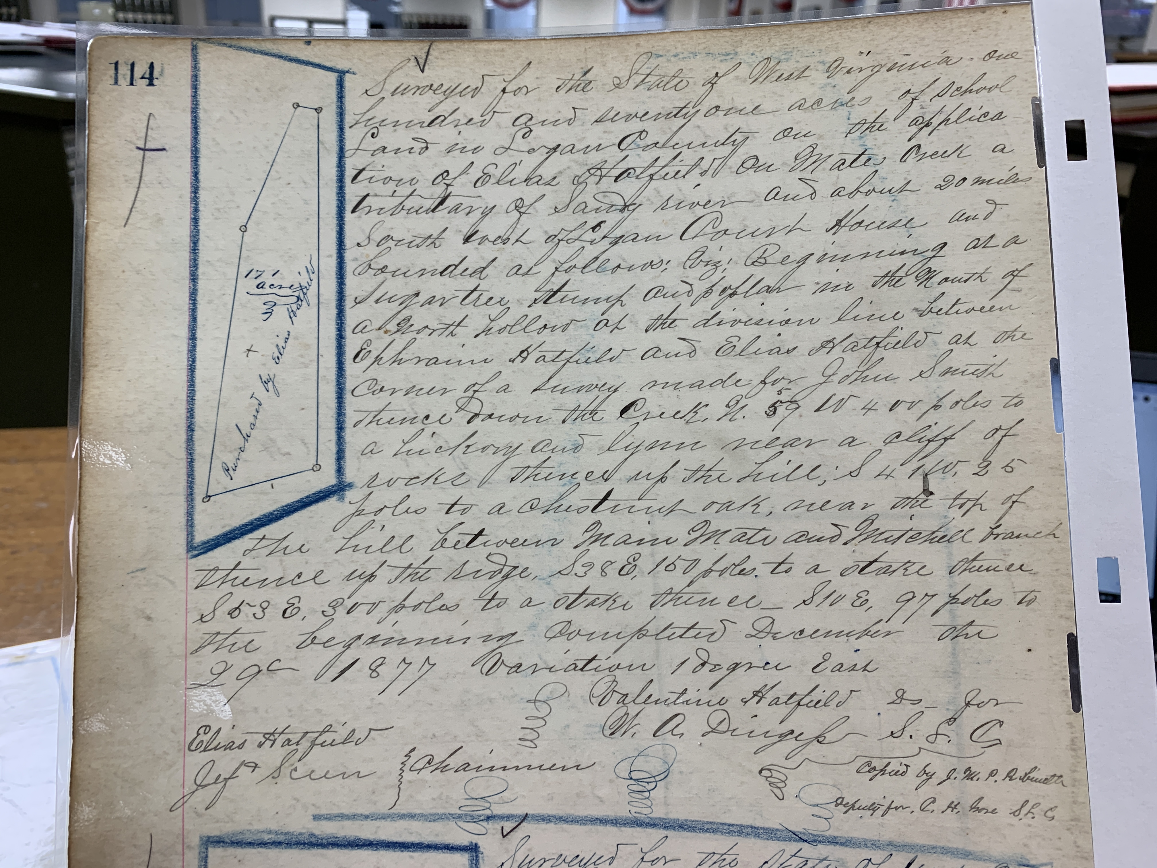
Elias Hatfield, Logan County, 1431 acres

M.A. Ferrell, Logan County, 1300 acres

T.W. Blankenship, Roane County, 1200 acres

1887

William S. Ferrell, Logan County, 2650 acres, Thackers Creek and Sandy River

Warren Alderson, Morehead KY, 2640 acres, Sandy River

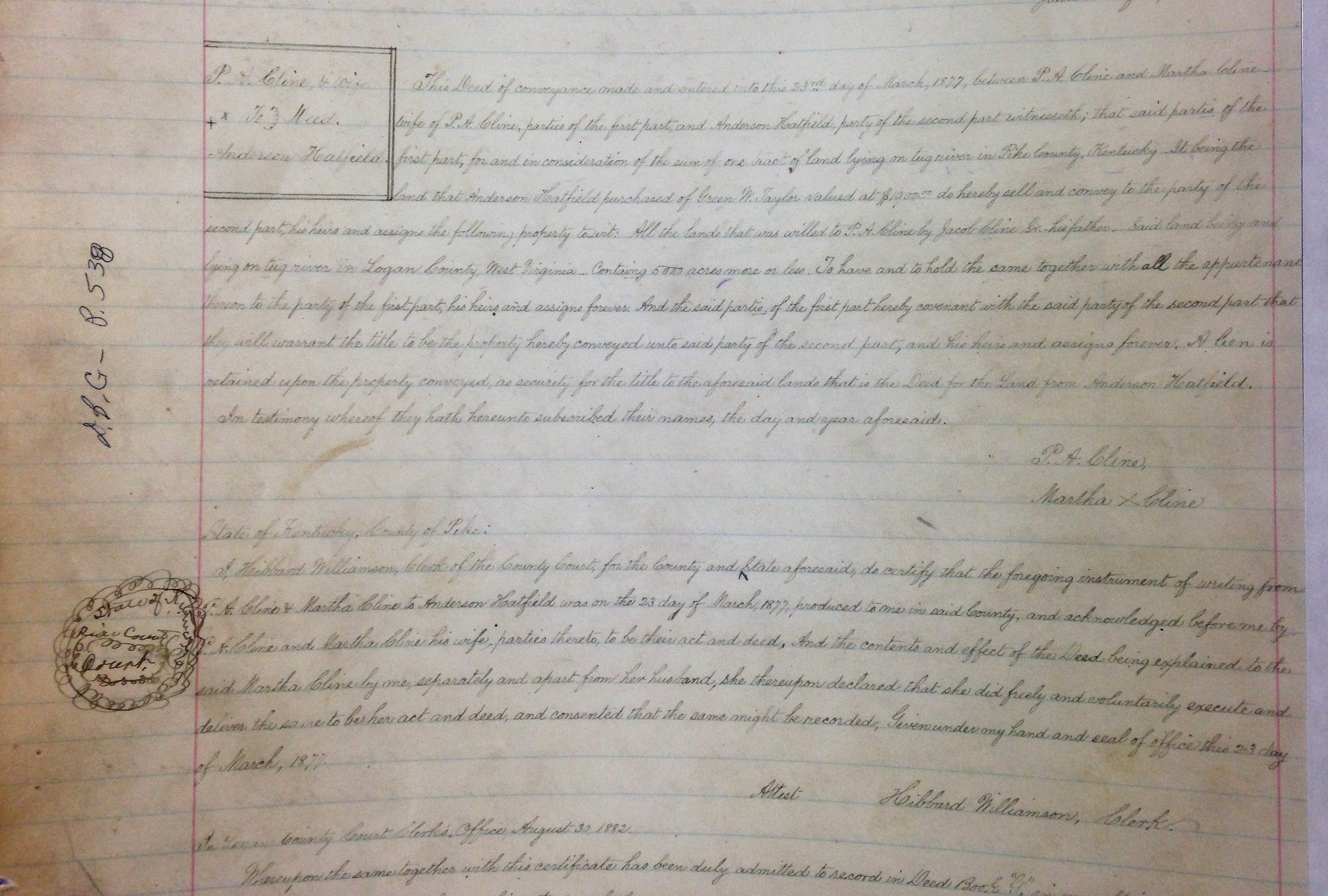
Anderson Hatfield, Logan County, 2360 acres, Grape Vine

J.D. Sergeant, Philadelphia PA, 1481 acres, Beech Creek

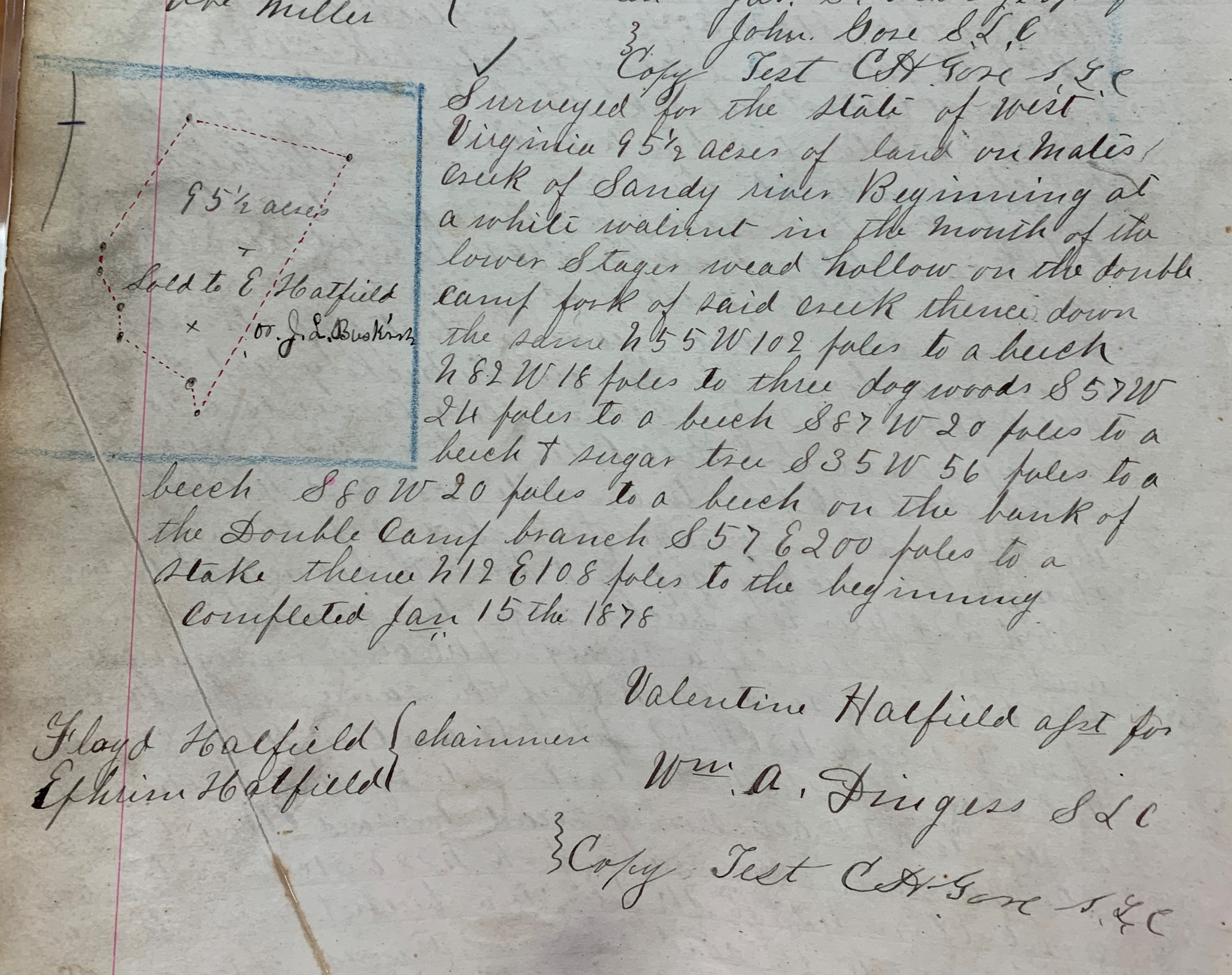
Elias Hatfield, Logan County, 1471 acres, Four tracts on Mates Creek

M.A. Ferrell, Logan County, 1300 acres, Sandy River

T.W. Blankenship, Roane County, 1200 acres, Spruce Fork of Ben Creek

1888

Anderson Hatfield, Logan County, 2656 1/2 acres, Grapevine Creek

William S. Ferrell, Logan County, 2650 acres, Thacker and Sandy

J.C. Williamson, Logan County, 1837 acres, Four tracts on Alum and Sandy River

Lewis Ratcliff, Logan County, 1600 acres, Sandy River

John Francesco, Logan County, 1500 acres, Grapevine and Thacker

Simpkins and M.B. Lawson’s Heirs, Logan County, 1500 acres, Richard Ratcliff Farm and Sandy River

Elkhorn Sandy R. Trust Co., Logan County, 1481 acres, Ben Creek and Sandy

J.D. Sergeant, Philadelphia PA, 1385 acres, Sandy River

M.A. Ferrell*, Logan County, 1300 acres, Sandy River

1889

Anderson Hatfield, Logan County, 2656 1/2 acres, Grapevine Creek

W.S. Ferrell, Logan County, 2650 acres, Thacker and Sandy River

J.C. Williamson, Logan County, 1837 acres, 4 Tracts on Alum and Sandy River

Lewis Rutherford, Logan County, 1600 acres, Sandy River

Jacob Smith, Logan County, 1500 acres, Richard Ratcliff’s Farm and Sandy River

John Francesco, Logan County, 1500 acres, Grape Vine

Elkhorn Sandy River Trust Company, Logan County, 1481 acres, Ben Creek and Sandy River

J.D. Sergeant, Philadelphia PA, 1385 acres, Sandy River

Joseph Glen, Logan County, 1377 acres, Tug River Below Mouth Bend

J.D. Sergeant, Philadelphia PA, 1354 1/4 acres, Mates Creek

J.D. Sergeant, Philadelphia PA, 1338 3/4 acres, Grapevine

M.A. Ferrell*, Logan County, 1300 acres, Sandy River

Alex D. Trent, Logan County, 1246 acres, Spring Fork Ben Creek

Note: On November 6, 1888, M.A. Ferrell was elected justice of the peace; his term commenced on January 1, 1889.

Source: Land Book 1866-1872, Land Book 1873-1874, Land Book 1880-1886, and Land Book 1887-1892.

Cap Hatfield Property in Logan County, WV (1886-1894)

18 Thursday Feb 2021

Posted by Brandon Ray Kirk in Big Sandy Valley, Hatfield-McCoy Feud, Matewan

≈ Leave a comment

Tags

Appalachia, Big Sandy River, Cap Hatfield, feuds, Grapevine Creek, Hatfield-McCoy Feud, history, J.D. Sergeant, Logan County, Nancy E. Hatfield, Philadelphia, Reece Browning, Tug Fork, West Virginia

The following land information is derived from Land Book 1880-1886, Land Book 1887-1892, and Land Book 1893-1899 at the Logan County Clerk’s Office in Logan, WV:

Anderson Hatfield, Jr.

No property listed in 1865-1885.

1886: Magnolia District

400 acres Grapevine Creek $1.25 per acre no building $[blank]

300 acres Grapevine Creek $1.25 per acre $30 building $315 total

[The 300-acre tract contained this additional note: “redeemed for 1884.”]

1887: Magnolia District

400 acres Grape Vine $1.25 per acre no building $500 total

300 acres Grape Vine $1.25 per acre no building $375 total

1888-1890: Magnolia District

No property listed for Cap.

[Note: On January 30, 1888, he transferred with others two tracts on Grapevine Creek, Sandy River worth $1.25 per acre with total value of $875 to J.D. Sergeant of Philadelphia, PA.]

1891: Logan District

Nancy E. Hatfield

75 acres Island Creek $2 per acre no building $150 total

[Note: This property was “transferred from Reece Browning.”]

1892-1893: Logan District

Nancy E. Hatfield

75 acres Island Creek $2.50 per acre no building $187.50 total

1894: Logan District

Nancy E. Hatfield

75 acres Island Creek, $2.50 per acre no building $188 total

Subpoena for Sam McCoy (1882)

18 Thursday Feb 2021

Posted by Brandon Ray Kirk in Big Sandy Valley, Hatfield-McCoy Feud

≈ Leave a comment

Tags

Amos Acord, Appalachia, Bill Staton, county clerk, crime, feuds, Hatfield-McCoy Feud, history, John Chafin, Logan County, Mingo County, murder, Sam McCoy, true crime, West Virginia

Amos Acord subpoena (1882). Sam McCoy was accused of murdering Bill Staton in 1880.

Johnson Hatfield Property in Logan County, WV (1884-1892)

18 Thursday Feb 2021

Posted by Brandon Ray Kirk in Big Sandy Valley, Hatfield-McCoy Feud, Matewan

≈ Leave a comment

Tags

Appalachia, Ben Creek, Big Sandy River, Devil Anse Hatfield, genealogy, Grapevine Creek, H.R. Phillips, Hatfield-McCoy Feud, history, J.D. Sergeant, Johnse Hatfield, Johnson Hatfield, justice of the peace, Left Hand Fork, Levicy Hatfield, Lick Branch, Lick Fork, Logan County, Magnolia District, Mingo County, Nancy Hatfield, Philadelphia, Thacker Creek, Valentine Wall Hatfield, West Virginia

The following land information is derived from Land Book 1880-1886 and Land Book 1887-1892, as well as deed books, at the Logan County Clerk’s Office in Logan, WV:

Johnson Hatfield

No property listed in land books for 1865-1881.

On January 28, 1882, Anderson and Vicy Hatfield deeded 200 acres at Lick Fork of Grapevine Creek to Johnson Hatfield (all of Logan County) for $250. Began at a large rock near the creek bank just above the garden field at the mouth of Lick Fork, thence running out to the center of the point above Lick Fork…to the head of Lick Fork and down the top of the ridge between Grapevine and Thacker Creek… Anderson and Vicy Hatfield signed the deed. Justice Valentine Hatfield witnessed the deed on January 28, 1882.

No property listed in land books for 1883.

1884-1885: Magnolia District

Johnson Hatfield, Jr.

200 acres Lick Branch, Grape Vine $1.25 per acre no building $250 total

Johnson Hatfield, Sr.

200 acres Lick Branch, Grape Vine $1.25 per acre no building $250 total

[Note: Two entries exist in the land book for a Johnson Hatfield (Sr. and Jr.) in 1884-1885; this is likely the same person and the same property.]

1886: Magnolia District

No entry for him.

1887: Magnolia District

Nancy Hatfield

300 acres Grapevine, Sandy River $1.25 per acre no building $375 total

[Note: This property was transferred from Johnson Hatfield. Presumably, “Nancy Hatfield” is Johnse’s wife, the former Nancy McCoy.]

1888: Magnolia District

No entry for Johnson or Nancy Hatfield.

[Note: On January 30, 1888, Johnson Hatfield, Jr. transferred 500 acres on Grapevine, Sandy River (two tracts) worth $1.25 and total value of $625 to J.D. Sergeant of Philadelphia, PA.]

1889: Magnolia District

No property listed.

1890: Magnolia District

Nancy Hatfield

147 acres H.R. Fk Mates Creek $1 per acre no building $147 total

[Note: This may be Johnse’s wife, Nancy.]

1891: Magnolia District

No property listed.

[In 1891, “Jo Hatfield & wife” transferred 258 acres on Left Hand Fork Ben Creek worth $1 per acre and with total value of $258 to H.R. Phillips, trustee. This may or may not be Johnse Hatfield.]

Ellison Hatfield Property in Logan County, WV (1880-1893)

16 Tuesday Feb 2021

Posted by Brandon Ray Kirk in Big Sandy Valley, Hatfield-McCoy Feud, Matewan

≈ Leave a comment

Tags

Appalachia, Double Camp Branch, Ellison Hatfield, Ephraim Hatfield, genealogy, H.R. Phillips, Hatfield-McCoy Feud, history, Logan County, Magnolia District, Mates Creek, Mingo County, West Virginia

The following land information is derived from Land Book 1880-1886, Land Book 1887-1892, and Land Book 1893-1899 at the Logan County Clerk’s Office in Logan, WV:

Ellison Hatfield

No property listed in 1865-1879.

1880: Magnolia District

50 acres Double Camp Fork, Ben Creek $0.25 per acre no building $12.50

300 acres Mates Creek $0.25 per acre no building $75 total

[Note: The 300-acre tract was transferred from Ephraim Hatfield.]

1881: Magnolia District

50 acres Double Camp Fork Mates Creek $0.25 per acre no building $12 total

276 acres Mates Creek $0.25 per acre no building $69 total

[Note: The reduction of the 300-acre tract is unexplained.]

1882: Magnolia District

The Hatfield page is missing.

1883: Magnolia District

No records are listed for this year.

1884: Magnolia District

50 acres Double Camp Br. Mates Creek $2.50 per acre $25 building $125 total

276 acres Double Camp Br. Mates Creek $1 per acre no building $276 total

20 acres Double Camp Mates Creek $1 per acre no building $20 total

[Note: The 50-acre and 276-acre tract is listed in the name of “Ellison Hatfield’s Heirs”. The 20-acre tract is listed in the name of Ellison Hatfield.]

1885: Magnolia District

50 acres Double Camp Branch, Mates Creek $2.50 per acre $25 building $125 total

276 acres Double Camp Branch, Mates Creek $1 per acre no building $276 total

50 acres Double Camp Branch, Mates Creek $2.50 per acre $30 building $125 total

1886: Magnolia District

50 acres Mates Creek $2.50 per acre no building $56 total

20 acres Mates Creek $1 per acre no building $130 total

1887-1889: Magnolia District

Ellison Hatfield

50 acres Mates Creek $2.50 per acre $30 building $125 total

20 acres Mates Creek $1 per acre no building $20 total

Ellison Hatfield’s Heirs

50 acres Double Camp, Mates Creek $2.50 per acre $25 building $125 total

276 acres Double Camp, Mates Creek $1 per acre no building $276 total

20 acres Double Camp, Mates Creek $1 per acre no building $20 total

[Note: In 1887, the latter three tracts are noted as “one yr back tax & interest.” In 1888, the latter three tracts are noted as “sold to Okeefe for tax.” In 1889, the latter three tracts are restored to Ellison Hatfield’s heirs.]

1890-1891: Magnolia District

Ellison Hatfield

50 acres Mates Creek $2.50 per acre $30 building $125 total

20 acres Mates Creek $1 per acre no building $20 total

Ellison Hatfield’s Heirs

50 acres Double Camp, Mates Creek $2.50 per acre $25 building $125 total

276 acres Double Camp, Mates Creek $1 per acre no building $276 total

28 acres Double Camp, Mates Creek $1 per acre no building $28 total

1892: Magnolia District

Ellison Hatfield

50 acres Mates Creek $2.50 per acre $25 building $125 total

20 acres Mates Creek $2 per acre $40 building $175 total

Ellison Hatfield’s Heirs

50 acres Double Camp, Mates Creek $3.50 per acre $30 building $175 total

276 acres Double Camp, Mates Creek $3.50 per acre no building $966 total

28 acres Double Camp, Mates Creek $3.50 per acre no building $98 total

1893: Magnolia District

Ellison Hatfield

50 acres Mates Creek $2.50 per acre $30 building $125 total

20 acres Mates Creek $2 per acre no building $40 total

[In 1893, Ellison Hatfield’s heirs by commissioner transferred 250 acres on Mates Creek worth $3.50 per acre and total value of $875 to H.R. Phillips, trustee.]

Hatfield-McCoy Feud Radio Spot

16 Tuesday Feb 2021

Posted by Brandon Ray Kirk in Big Sandy Valley, Hatfield-McCoy Feud

≈ Leave a comment

Tags

Appalachia, Big Sandy River, Elias Hatfield, feuds, fiddle, Floyd Hatfield, Hatfield-McCoy Feud, history, Johnse Hatfield, Kentucky, Randolph McCoy, Roseanna McCoy, Tolbert McCoy, Tug Fork, West Virginia

Randolph McCoy-Floyd Hatfield hog trial…
Romance between Johnse Hatfield and Roseanna McCoy; Ellison Hatfield’s Killing…

Smith and Patterson Hatfield Property in Logan County, WV (1878-1894)

15 Monday Feb 2021

Posted by Brandon Ray Kirk in Big Sandy Valley, Hatfield-McCoy Feud, Matewan

≈ Leave a comment

Tags

Appalachia, Ephraim Hatfield, genealogy, Hatfield-McCoy Feud, history, Logan County, Magnolia District, Marks Branch, Mates Creek, Mingo County, Nancy Hatfield, Patterson Hatfield, Smith Hatfield, West Virginia

The following land information is derived from Land Book 1873-1874, Land Book 1880-1886, and Land Book 1893-1899 at the Logan County Clerk’s Office in Logan, WV:

Smith and Patterson Hatfield

No property listed in 1865-1877.

1878: Magnolia District

Smith and Patterson Hatfield

100 acres Mates Creek $4 per acre $25 building $400 total

[Note: This tract was transferred from Ephraim Hatfield in 1878.]

Smith Hatfield

25 acres Marks Branch, Mates Creek $0.20 per acre no building $5 total

1879: Magnolia District

No records for this year.

1880-1881: Magnolia District

Smith and Patterson Hatfield

100 acres Mates Creek $4 per acre $25 building $400 total

Smith Hatfield

25 acres Marks Branch, Mates Creek $0.20 per acre no building $5 total

[Note: In the 1880 census, widowed Nancy Hatfield lived with her son, Patterson.]

1882: Magnolia District

The Hatfield page is missing.

1883: Magnolia District

The page is mostly blank but does list:

Smith Hatfield 25 acres M__ Br of Mates Creek $2.50 per acre [rest is blank]

1884-1885: Magnolia District

Smith and Patterson Hatfield

100 acres Mates Creek $3 per acre $35 building $300 total

Smith Hatfield

25 acres Marks Br. of Mates Creek $2.50 per acre no building $62.50 total

1886: Magnolia District

Smith and Patterson Hatfield

100 acres Mates Creek $3 per acre no building $230 total

Smith Hatfield

25 acres Mack Branch, Mates Creek $2.50 per acre [blank]

1887-1888: Magnolia District

Smith and Patterson Hatfield

100 acres Mates Creek $3 per acre $35 building $300 total

Smith Hatfield

25 acres Marks Branch, Mates Creek $2.50 per acre no building $62.50 total

1889: Magnolia District

Smith Hatfield

25 acres Mark Branch, Mate Creek $2.50 per acre no building $65 total

Pat Hatfield

50 acres Mates Creek $3 per acre $35 building $150 total

1890: Magnolia District

Smith Hatfield

25 acres Mate Creek $2.50 per acre no building $65 total

50 acres Mate Creek $3 per acre $35 building $150 total

Patterson Hatfield

50 acres Mate Creek $3 per acre $30 building $150 total

1891-1892: Magnolia District

Smith Hatfield

25 acres Mate Creek $2.50 per acre no building $62.50 total

50 acres Mate Creek $3 per acre $35 building $150 total

Patterson Hatfield

50 acres Mate Creek $3 per acre $30 building $150 total

1893-1894: Magnolia District

Smith Hatfield

25 acres Mate Creek $2.50 per acre no building $62.50 total

50 acres Mate Creek $3 per acre $40 building $150 total

Patterson Hatfield

50 acres Mate Creek $2.50 per acre $40 building $125 total

Valentine “Wall” Hatfield Property in Logan County (1874-1893)

13 Saturday Feb 2021

Posted by Brandon Ray Kirk in Big Sandy Valley, Hatfield-McCoy Feud

≈ 1 Comment

Tags

Appalachia, Beech Creek, Big Sandy River, Doc Mahon, Double Camp Branch, Ephraim Hatfield, genealogy, Hatfield-McCoy Feud, history, J.D. Sergeant, Jane Hatfield, Logan County, Magnolia District, Mingo County, Philadelphia, Valentine Wall Hatfield, West Virginia

The following land information is derived from Land Book 1873-1874, Land Book 1880-1886, Land Book 1887-1892, and Land Book 1893-1899 at the Logan County Clerk’s Office in Logan, WV:

Valentine Hatfield

No property listed in 1865-1873.

1874: Magnolia District

84 acres Beech Creek, Sandy River $5.25 per acre no building $441 total

144 acres Double Camp Branch, Beech $0.10 per acre no building $14.40 total

[Note: Regarding the latter tract, the book reads “entered on Books and corrected.”]

1875: Magnolia District

84 acres Beech Creek, Sandy River $5.25 per acre no building $441 total

144 acres Double Camp Branch, Beech $0.25 per acre no building $36 total

1876: Magnolia District

84 acres Beech Creek, Sandy River $5.25 per acre no building $441 total

144 acres Double Camp Branch, Beech $0.10 per acre no building $14.40 total

1877: Magnolia District

The record is blank.

1878: Magnolia District

48 acres Beech Creek $5.25 per acre no building $141 total

144 acres Double Camp Branch, Beech Creek $0.25 per acre no building $36 total

1879: Magnolia District

No records for this year.

1880-1881: Magnolia District

84 acres Beech Creek $5.25 per acre no building $441 total

144 acres Double Camp and Mates Creek $0.25 per acre no building $36 total

1882: Magnolia District

The Hatfield page is missing

1883: Magnolia District

The record is blank for this year.

1884-1885: Magnolia District

84 acres Beech Creek, Sandy River $5 per acre $50 building $420 total

144 acres Double Camp, Sandy River $1 per acre no building $144 total

1886: Magnolia District

84 acres Beech Creek, Sandy River $5 per acre $15 building $125 total

114 acres Double Camp, Sandy River $1 per acre $75 building $280 total

1887: Magnolia District

84 acres Beech Creek $5 per acre $50 building $420 total

144 acres Double Camp, Mates Creek $1 per acre no building $144 total

1888: Magnolia District

44 acres Beech Creek $5 per acre $50 building $220 total

144 acres Beech Creek $1 per acre no building $144 total

[Note: In this year, Wall Hatfield transferred 40 acres of the 84-acre tract to Doc Mahon.]

1889: Magnolia District

No property listed.

[In 1889, he transferred 89 acres on Beech Creek worth $1 per acre and total value of $89 to Ephraim Hatfield. Also, transferred with others 126 acres on Beech Creek worth $1 per acre and total value of $126 to J.D. Sergeant of Philadelphia.]

1890: Magnolia District

No property listed.

[Note: Wall Hatfield died on February 13, 1890 at Frankfort, KY.]

1891: Magnolia District

Jane Hatfield

84 acres, Beech Creek, $2 per acre, no building, $168 total

[Note: “Entered with 1 yr B tax.”]

1892-1893: Magnolia District

Jane Hatfield

84 acres, Beech Creek, $2.50 per acre, $40 building, $210 total

Elias Hatfield Property in Logan County (1869-1894)

12 Friday Feb 2021

Posted by Brandon Ray Kirk in Big Sandy Valley, Guyandotte River, Hatfield-McCoy Feud, Logan, Matewan

≈ Leave a comment

Tags

Appalachia, Big Island, Big Sandy River, E.K. Counts, Elias Hatfield, genealogy, George W. Duty, Hardee District, Hatfield-McCoy Feud, history, Logan County, Logan County Banner, Logan District, Magnolia District, Magnolia Township, Mates Creek, Mingo County, Oliver Perry, Warren Alderson, West Virginia

The following land information is derived from Land Book 1866-1872, Land Book 1873-1874, Land Book 1880-1886, Land Book 1887-1892 , and Land Book 1893-1899 at the Logan County Clerk’s Office in Logan, WV:

Elias Hatfield

No property listed in 1865-1868.

1869-1870: Magnolia Township

100 acres Mates Creek $4.00 per acre no building $400 total from E.K. Counts

30 acres Mates Creek $10 per acre no building $300 total from E.K. Counts

50 acres Mates Creek $20 per acre no building $1000 total from E.K. Counts

1871: Magnolia Township

100 acres Mates Creek $3.00 per acre $50 building $300 total

30 acres Mates Creek $3.00 per acre no building $90 total

50 acres Mates Creek $3.00 per acre no building $150 total

1872: Magnolia Township

100 acres Mates Creek $3.00 per acre $50 building $300 total

30 acres Mates Creek $3.00 per acre no building $90 total

50 acres Mates Creek $3.00 per acre no building $150 total

50 acres Mates Creek $3.00 per acre no building $150 total

350 acres Mates Creek $0.25 per acre no building $87.50 total from W. Alderson (assessor)

1873: Magnolia District

100 acres Mates Creek $3.00 per acre no building $300 total

30 acres Mates Creek $3.00 per acre no building $40 total

50 acres Mates Creek $3 per acre no building $150 total

400 acres Two Tracts Mates Creek $1 per acre no building $400 total

50 acres Mates Creek $3 per acre no building $150 total

350 acres Mates Creek $0.25 per acre no building $87.50 total

1874: Magnolia District

100 acres Mates Creek $3.00 per acre $50 building $300 total

50 acres Mates Creek $3 per acre no building $150 total

30 acres Mates Creek $3.00 per acre no building $40 total

400 acres Two Tracts Mates Creek $1 per acre no building $400 total

50 acres Mates Creek $3 per acre no building $150 total

350 acres Mates Creek $0.25 per acre no building $87.50 total

1875-1876: Magnolia District

100 acres Mates Creek $3.00 per acre $50 building $300 total

50 acres Mates Creek $3 per acre no building $150 total

30 acres Mates Creek $3.00 per acre no building $40 total

400 acres Two Tracts Mates Creek $1 per acre no building $400 total

50 acres Mates Creek $3 per acre no building $150 total

[Note: In 1875, Elias transferred his 350-acre tract but records do not identify the recipient.]

1877: Magnolia District

Records are blank for this district.

1878: Magnolia District

100 acres Mates Creek $3 per acre $50 building $300 total

30 acres Mates Creek $3 per acre $90 building $90 total

400 acres 2 Tracts, Mates Creek $0.25 per acre no building $100 total

50 acres Mates Creek $2 per acre no building $100 total

[Note: Records for this year spelled his name as Allias Hatfield.]

1879: Magnolia District

Records are missing for this year

1880: Magnolia District

100 acres Mates Creek $3 per acre $50 building $300 total

30 acres Mates Creek $3 per acre $90 building $90 total

400 acres 2 Tracts, Mates Creek $0.25 per acre no building $100 total

50 acres Mates Creek $2 per acre no building $100 total

1881: Magnolia District

100 acres Mates Creek $3 per acre no building $300 total

30 acres Mates Creek $3 per acre no building $90 total

400 acres 2 Tracts, Mates Creek $0.25 per acre no building $100 total

50 acres Mates Creek $2 per acre no building $100 total

[Note: The 100-acre tract was noted with this: “yrs from G.W. Duty.” The 30 acre tract was noted as “change to Hardee Dist on Book 1882.”]

1882: Magnolia District

The Hatfield page is missing.

1883: Magnolia District

The record is blank for this district

1884: Magnolia District

100 acres Mates Creek $3 per acre $50 building $300 total

30 acres Mates Creek $4 per acre $30 building $120 total

400 acres 2 Tracts, Mates Creek $1 per acre no building $400 total

50 acres Mates Creek $3 per acre no building $150 total

1885: Magnolia District

100 acres Mates Creek $3 per acre $50 building $300 total

30 acres Mates Creek $4 per acre $30 building $120 total

400 acres 2 Tracts, Mates Creek $1 per acre no building $400 total

50 acres Mates Creek $3 per acre no building $150 total

749 acres Mates Creek $1 per acre no building $749

322 acres Mates Creek $1 per acre no building $322 total

[In 1885, he acquired the 749-acre tract from a commissioner. No indication is given about the source of the 322 acres.]

1886: Magnolia District

100 acres Mates Creek $3 per acre [blank]

30 acres Mates Creek $4 per acre [blank]

50 acres Mates Creek $3 per acre [blank]

1471 acres 4 Tracts Mates Creek $1 per acre [blank]

600 acres Sandy River $1.90 per acre no building $56 total

1887: Magnolia District

100 acres Mates Creek $3 per acre $50 building $300 total

30 acres Mates Creek $4 per acre $30 building $120 total

50 acres Mates Creek $3 per acre no building $150 total

1471 acres 4 Tracts, Mates Creek $1 per acre no building $1471 total

600 acres Sandy River $1.90 per acre $40 building $1140 total

1888: Magnolia District

600 acres Sandy River $1.90 per acre $40 building $1140 total

1889-1891: Magnolia District

600 acres Sandy River $1.90 per acre $40 building $1140 total

1889-1891: Logan District

30 acres Big Island $20 per acre no building $600 total

13 acres Big Island and Washed Part $1 per acre no building $13 total

[Note: The 30-acre tract was acquired from Oliver Perry. No indication of the source for the 13 acres. According to the 21 March 1889 issue of the Logan County Banner: “On the 18th inst., Elias Hatfield, purchased of Oliver Perry, the property known as the ‘Big Island’ near this place.”]

1892-1894: Magnolia District

400 acres Sandy River $5 per acre $50 building $2000 total

1892-1894: Logan District

25 acres Big Island Guyandotte River $20 per acre no building $500 total

18 acres Big Island Guyandotte River $1 per acre no building $18 total

Anderson Hatfield Property in Logan County (1869-1893)

12 Friday Feb 2021

Posted by Brandon Ray Kirk in Big Sandy Valley, Hatfield-McCoy Feud, Matewan

≈ Leave a comment

Tags

A.E. Steel, Anna Hatfield, Appalachia, Beech Creek, Big Sandy River, Charles R. Mounts, Conley Bottom, Conleys Creek, Daniel Christian, Dempsey Branch, Devil Anse Hatfield, Double Camp, Double Camp Branch, E.S. Murphy, Ephraim Hatfield, Floyd Hatfield, genealogy, George Hatfield, Grapevine Creek, Harrison Steel, history, Island Creek, J.D. Sergeant, Jacob Francesco, James A. Nighbert, James Ferrell, James Mounts, John Green, Johnson Hatfield, justice of the peace, L.D. Steel, Levicy Hatfield, Lewis Steel, Lick Fork, Little Kanawha Lumber Company, Logan County, Logan District, logging, Magnolia District, Magnolia Township, Mash Field, Mate Creek, Mates Creek, Meadow Branch, Mill Seat Fork, miller, Mingo County, Moses Christian, Nancy Hatfield, Philadelphia, Pigeon Creek, Plyant Mayhorn, Polly Hatfield, Preacher Anse Hatfield, Road Fork, Samuel Mayhorn, splash dams, splashing, Stuart Wood, Thacker Creek, timbering, Tug Fork, Tug River, Valentine Wall Hatfield, West Virginia, William Tiller, Wolf Pen Fork

The following land information is derived from Land Book 1866-1872, Land Book 1873-1874, Land Book 1880-1886, Land Book 1887-1892, and Land Book 1893-1899, as well as various deed books, at the Logan County Clerk’s Office in Logan, WV:

Anderson Hatfield

[Property listed in name of Levecy Hatfield in 1869, Levica Hatfield in 1870-1871, Levisa Hatfield in 1872, 1874, and 1876, Levitna Hatfield in 1873, Lavisa Hatfield in 1875, Levica Hatfield in 1889, Lovicy Hatfield in 1890-1891, Lovica Hatfield in 1892, and Levicy Hatfield in 1893.]

No property listed in land books for 1865-1867.

On October 19, 1867, George* and Nancy Hatfield of Pike County, KY, deeded 100 acres on Mate Creek to Levicy Hatfield of Logan County, WV, for five hundred dollars. The property began in the upper end of Mash Field and extended to the mouth of Meadow Branch. Witnessed by JP William Tiller on October 19, 1867.

No property listed in the land book for 1868.

1869: Magnolia Township

100 acres Mates Creek $4.20 per acre no building $420 total

55 acres Mates Creek $2.10 per acre $75 building $136.50 total

[Note: Based on the land book, both tracts were acquired in 1869 from George Hatfield of Kentucky. Also, the 55-acre total value figure did not include the value of the building. Note the actual date of purchase for one of the tracts was 1867, as per the deed.]

1870: Magnolia Township

100 acres Mates Creek $4.20 per acre no building $420 total

55 acres Mates Creek $2.10 per acre no building $136.50 total

1871-1872: Magnolia Township

100 acres Mates Creek $4.20 per acre no building $420 total

55 acres Mates Creek $2.10 per acre no building $115.50 total

[Note discrepancy in the valuation for the 55-acre tract.]

1873: Magnolia District

100 acres Mates Creek $5.25 per acre no building $441 total

55 acres Mates Creek $4.20 per acre no building $420 total

1874: Magnolia District

100 acres Mates Creek $4.20 per acre no building $420 total

55 acres Mates Creek $2.10 per acre $115.50 total

On December 29, 1874, Anderson and Lovicy Hatfield sold 200 acres to Polly Hatfield (all of Logan County) for $780 on Mates Creek. Began at the foot of the north hill at the upper end of the old Mash Field, a conditional corner between Ephraim Hatfield and Anderson Hatfield to the mouth of Meadow Branch to include all the land that George Hatfield had deeded to Lovicy Hatfield. Anderson and Lovicy signed the deed using an “x.” Justice of the peace Valentine Hatfield witnessed the deed on December 29, 1874.

[Note the original 100 acres from the 1867 deed has now become 200 acres.]

1875: Magnolia District

100 acres Mates Creek $4 per acre $50 building $400 total

55 acres Mates Creek $0.25 per acre no building $13.75 total

1876: Magnolia District

100 acres Mates Creek $4 per acre no building $400 total

55 acres Mates Creek $0.25 per acre no building $13.75

[Note: In 1876, according to the land book, Anderson Hatfield transferred 200 acres on Mates Creek worth $0.25 per acre and with a total worth of fifty dollars to Polly Hatfield; the deed is dated 1874 (see above); the 1878 land record corrected the acreage to 55 acres by order of P.A. Counts]

1877: Magnolia District

No records available for this year.

On July 2, 1877, Anderson and Lovicy Hatfield deeded 150 acres at Double Camp and Road forks of Mates Creek for $75 to Floyd Hatfield (all of Logan County). Began at the back line of the John Green survey below Double Camp, then up the main ridge to the top of the point above Road Fork, thence to John Green survey line. Anderson and Lovicy signed the deed using an “x.” Justice of the Peace Valentine Hatfield witnessed the deed on July 2, 1877.

On December 24, 1877, Anderson and Levisa Hatfield deeded 1500 acres on Grapevine Creek to James Vance, Jr. (all of Logan County) for $1400. Began near the mouth of Wolf Pen Fork, thence to the top of the mountain between Grapevine and the river, thence with mountain to dividing ridge between Grapevine and Beech Creek, thence to head of Thacker Creek, thence down ridge between Thacker and Mates Creek… References the ridge between the Wolf Pen and Mill Seat Fork. Anderson and Levicy signed the deed using an “x.” Justice Valentine Hatfield witnessed the deed on December 24, 1877.

1878: Magnolia District

Anse Hatfield owned no property in 1878.

[In 1878, as per the land book, Anderson Hatfield transferred 150 acres on Double Camp and Road Fork of Mate to Floyd Hatfield worth twenty cents per acre and with a total worth of $20. Records showed this as “transferred from Anderson Hatfield.” Note: The deed (above) shows the transfer as 1877.]

1879: Magnolia District

No records exist for this year.

1880-1881: Magnolia District

As per land book, Anse Hatfield owned no land.

On December 9, 1880, Anderson Hatfield, Lovicy Hatfield, Elias Hatfield, and Henry Mitchell deeded 200 acres on Wolf Pen Fork of Grapevine Creek to Robert Cox (all of Logan County) for $200. Anderson Hatfield, Lovicy Hatfield, Elias Hatfield, and Henry Mitchell signed the deed. Justice of the peace Valentine Hatfield witnessed the deed on December 10, 1880.

1882: Magnolia District

The Hatfield page is missing from the land book.

On January 28, 1882, Anderson and Vicy Hatfield deeded 200 acres at Lick Fork of Grapevine Creek to Johnson Hatfield (all of Logan County) for $250. Began at a large rock near the creek bank just above the garden field at the mouth of Lick Fork, thence running out to the center of the point above Lick Fork…to the head of Lick Fork and down the top of the ridge between Grapevine and Thacker Creek… Anderson and Vicy Hatfield signed the deed. Justice Valentine Hatfield witnessed the deed on January 28, 1882.

1883: Magnolia District

Records for this district are blank.

1884: Magnolia District

37 acres Tug River $1 per acre no building $37 total

2900 acres Grape Vine, Tug River $1.25 per acre $50 building $3625 total

[Note: In 1884, Anse transferred 100 acres to Daniel Christian on Grape Vine and Sandy River worth $1.25 per acre with no building and valued at $125. In 1884, Anse transferred 150 acres on Beech Creek and Sandy River to Jacob Francesco worth $1 per acre with no buildings and total value at $150. This latter tract states “by A. Hatfield by P. Mayhorn” and adds that “books don’t show A. Hatfield is owner.” Anse is not named in the 1884 deed to Jacob Francesco.]

1885: Magnolia District

37 acres Tug River $1 per acre no building $37 total

2750 acres Grapevine Creek and Tug River $1.25 per acre $50 building $3437.50 total

[In 1885, he transferred 50 acres on Sandy River to Moses Christian worth $1.25 per acre with a total worth of $62.50. In 1885, he transferred 100 acres on Grapevine Creek to Samuel Mayhorn worth $1.25 per acre with a total worth of $125.]

1886: Magnolia District

No property listed for him in 1886.

[In 1886, he transferred 500 acres on Pigeon Creek to James Ferrell worth $1.12 per acre with a total worth of $500. This note referenced him as “A. Hatfield Sr.” In 1886, he transferred 25 acres on Tug River to E.S. Murphy worth $1 per acre and a total worth of $25. In 1886, he transferred 340 acres on Beech Creek to Harrison Steel valued at $2.25 per acre and with a total worth of $765. This latter note stated: “2 years back tax and with interest; transferred from Ans Hatfield.”]

1887: Magnolia District

37 acres Tug River $1 per acre no building $37 total

2360 acres Grape Vine $1.25 per acre $50 building $2950 total

[Note: For both entries, the record reads: “one yr bk tax & interest.” In 1887, he transferred 69 acres on Sandy River worth $1 per acre and total worth of $69 to James Mounts. In 1887, he transferred with others 100 acres on Sandy River worth $1 per acre and total value of $100 to Charles R. Mounts. In 1887, he transferred 200 acres on Beech Creek to Harrison Steel worth $1 per acre and total value of $200.]

1888: Logan District

[On April 10, 1888, Lewis S. Steel sold 200 acres on Island Creek to Vicie Hatfield for $900. Deed Book L, p. 53.]

[On May 1, 1888, Anse and Levicy Hatfield agreed to a quit claim deed for mineral rights to 600 acres in the head of Island Creek to Stuart Wood for $1, and fifty cents per acre once surveyed and the title perfected. Deed Book K, p. 158-159.]

[On May 10, 1888, L.D. and A.E. Steel sold 250 acres on Island Creek to Levicy Hatfield for $500. Deed Book L, p. 52.]

1888: Magnolia District

No property listed for him, but a note in 1893 lists back taxes owed for:

Anderson Hatfield

2656 1/2 acres Grapevine Creek $3.50 per acre no building $9297.75 total

[Note: In 1888, he transferred 300 acres on Grapevine, Sandy River worth $1.25 per acre and total value of $375 to J.D. Sergeant of Philadelphia, PA. In 1888, he transferred along with others 1385 acres on Sandy River worth $1.25 per acre and total worth of $1632 to J.D. Sergeant.]

1889: Logan District

Levica Hatfield

250 acres Island Creek $1 per acre no building $250 total

200 acres Island Creek $1.40 per acre no building $280 total

1889: Magnolia District

Anderson Hatfield

2656 1/2 acres Grapevine Creek $3.50 per acre no building $9297.75 total

[On April 9, 1889, Anse and Levisy Hatfield deed to James E. Price, trustee, for $825 the mineral rights of 821 acres on Island Creek. Deed Book 47, p. 67-70.]

[On September 6, 1889, Anse Hatfield deeded all of the timber on his Island Creek property to the Little Kanawha Lumber Company for $352. References Anse having the right to put in a grist mill at the splash dam. Deed Book O, p. 410-411.]

1890-1891: Logan District

Lovicy Hatfield

250 acres Island Creek $1 per acre no building $250 total

200 acres Island Creek $1.40 per acre no building $280 total

[On November 21, 1891, Anse and Levicy Hatfield deeded to Stuart Wood and J.A. Nighbert for one dollar a right of way for splashing timber at the 821 acres. References Conley Bottom, the mouth of Dempsey Branch, and Conley’s Creek. Deed Book M, p. 189.]

1890-1891: Magnolia District

Anderson Hatfield

2656 1/2 acres Grapevine Creek $3.50 per acre no building $9297.75 total

1892: Logan District

Lovica Hatfield

250 acres Island Creek $2 per acre no building $500 total

200 acres Island Creek $5 per acre $500 building $1000 total

[On June 18, 1892, Anse and Levicy deeded to G.R. Buskirk for $2 his timber on 400 acres. Deed Book Q, p. 370.]

1892: Magnolia District

Anderson Hatfield

2656 1/2 acres Grapevine Creek $3.50 per acre no building $9297.75 total

1893-1894: Logan District

Levicy Hatfield

250 acres Island Creek $2 per acre no building $500 total

200 acres Island creek $5 per acre $500 building $1000 total

1893: Magnolia District

Anderson Hatfield

2656 1/2 acres Grapevine Creek $3.50 per acre no building $9297.75 total

[Note: In 1893, the tract at Grapevine Creek was noted: “entered with 5 yrs back taxes and interest.”]

1894: Magnolia District

Anderson Hatfield

2656 1/2 acres Grapevine Creek $3.50 per acre no building $9298 total

*George Hatfield (1804-1883), son of Ephraim and Anna (Musick) Hatfield; father of “Preacher Anse” Hatfield.

NOTE: Many discrepancies exist between the land books and deeds for Anderson Hatfield.

Perry A. Cline Deed to Anderson Hatfield (1877)

12 Friday Feb 2021

Posted by Brandon Ray Kirk in Big Sandy Valley, Hatfield-McCoy Feud

≈ Leave a comment

Tags

Devil Anse Hatfield, genealogy, Green W. Taylor, Hatfield-McCoy Feud, history, Jacob Cline Sr., Kentucky, Logan County, Martha Cline, Perry Cline, Pike County, Tug River, West Virginia

P.A. Cline to Anderson Hatfield, 5000 acres (23 March 1877), Deed Book __, page __, Logan County Clerk’s Office, Logan, WV.

Elias Hatfield Survey (1877)

11 Thursday Feb 2021

Posted by Brandon Ray Kirk in Big Sandy Valley, Hatfield-McCoy Feud, Matewan

≈ Leave a comment

Tags

Appalachia, Big Sandy River, Elias Hatfield, Ephraim Hatfield, Hatfield-McCoy Feud, history, John Smith, Logan County, Mates Creek, Mingo County, Mitchell Branch, Valentine Wall Hatfield, W.A. Dingess, West Virginia

Elias Hatfield, 171 acres of school land, Mates Creek, Surveyors Record Book B, Logan County Clerk’s Office, Logan, WV.

Ephraim Hatfield Property in Logan County (1865-1885)

02 Tuesday Feb 2021

Posted by Brandon Ray Kirk in Big Sandy Valley, Hatfield-McCoy Feud, Matewan

≈ Leave a comment

Tags

Appalachia, Beech Creek, Big Sandy River, Double Camp Branch, Ephraim Hatfield, genealogy, Hatfield-McCoy Feud, history, Lewis Ferrell, Logan County, Magnolia District, Magnolia Township, Mates Creek, Meador Branch, Mingo County, Murphys Branch, Nancy Varney, Patterson Hatfield, Smith Hatfield, Straight Fork, Valentine Wall Hatfield, West Virginia

The following land information is derived from Land Book 1866-1872, Land Book 1873-1874, Land Book 1880-1886, and Land Book 1887-1892 at the Logan County Clerk’s Office in Logan, WV:

Ephraim Hatfield

1865-1867: Magnolia Township

70 acres Murphys Branch, Mate Creek $0.50 per acre no building $35 total

125 acres Meadors Branch, Mate Creek $0.50 per acre no building $62.50 total

115 acres Mate Creek $6.00 $200 building $690 total

45 acres Double Camp $2.00 no building $90 total

20 acres South Side, Mate Creek [added in 1871, five years back tax]

24 acres Straight Fork $3.00 per acre no building $72 total

84 acres Beech Creek $5.00 per acre no building $420 total

1868: Magnolia Township

The book contains no entries for Magnolia Township)

1869-1872: Magnolia Township

70 acres John Murpheys Branch, Mate Creek $0.52 per acre no building $36.75 total

[125-acre tract was gone by 1869, bestowed to Nancy Varney, who had 125 acres on “Meadow” Branch worth $0.52 1/2 in 1869]

115 acres Mate Creek $6.30 per acre $200 building $724.50 total

45 acres Double Camp $2.10 per acre no building $94.50 total

20 acres South Side, Mate Creek $0.52 1/2 per acre no building $10.50 total

24 acres Straight Fork $3.15 per acre no building $75.60 total

84 acres Beech Creek $5.25 per acre no building $441 total

1873: Magnolia District

70 acres John Murpheys Branch, Mate Creek $0.52 per acre no building $36.75 total

[Note: The above building was likely noted in error.]

113 acres Mate Creek $6.30 per acre $200 building $724.50 total

[Note: The 115-acre tract is likely noted as 113 acres in error.]

45 acres Double Camp $2.10 per acre no building $94.50 total

20 acres South Side, Mate Creek $0.52 1/2 per acre no building $10.50 total

24 acres Straight Fork $3.15 per acre no building $75.60 total

84 acres Beech Creek $5.25 per acre no building $441 total

1874: Magnolia District

115 acres Mates Creek $6.30 per acre $200 building $724.50 total

45 acres Double Camp $2.10 per acre no building $94.50 total

20 acres S Side Mate Creek $0.52 per acre 1/2 no building $10.50 total

24 acres Trough? Fork $0.15? per acre no building $75.60 total

[Note: He transferred the 84-acre tract to Valentine Hatfield]

1875: Magnolia District

115 acres Mates Creek $4.00 per acre $45 building $460 total

45 acres Double Camp of Mates Creek $0.25 per acre no building $11.25 total

20 acres Double Camp $0.25 per acre no building $5.00 total

24 acres Strat Fork $0.25 per acre no building $6.00 total

1876: Magnolia District

115 acres Mate Creek $0.25 per acre no building $11.25 total

45 acres Double Camp Mates Creek $0.25 per acre no building $5.00 total

20 acres Double Camp Mates Creek $0.25 per acre no building $6.00 total

24 acres Straight Fork $0.25 per acre no building $18.75 total

1877: Magnolia District

Records are missing for this year.

1878: Magnolia District

15 acres Mates Creek $4.00 per acre $25 building $60 total

20 acres Double Camp Branch Mate Creek $0.25 per acre no building $5.00 total

24 acres Strate Fork Mate Creek $0.25 per acre no building $6.00 total

368 acres Mates Creek $0.10 per acre no building $36.80 total

[Note: In 1878, Ephraim transferred one tract of 100 acres on Mate Creek worth four dollars per acre containing a $25 building with a total worth of $400 to Smith and Patterson Hatfield. He also transferred one tract of 50 acres on Nashes Buck? Hollow Double Camp worth twenty-five cents per acre with no building and total worth of $12.50 to Floyd Hatfield.]

1879: Magnolia District

Records are missing for this year.

1880: Magnolia District

15 acres Mates Creek $4.00 per acre $25 building $60 total

20 acres Double Camp Branch Mate Creek $0.25 per acre no building $5.00 total

24 acres Strate Fork Mate Creek $0.25 per acre no building $6.00 total

68 acres Mates Creek $0.10 per acre no building $36.80 total

[Note: In 1880, Ephraim transferred 300 acres from the 368-acre tract to Ellison Hatfield. Note also that he died before the 1880 census.]

1881: Magnolia District

15 acres Mates Creek $4.00 per acre $25 building $375.00? total

20 acres Double Camp Branch Mate Creek $0.25 per acre no building $99.00 total

24 acres Strate Fork Mate Creek $0.25 per acre no building $200.00

68 acres Mates Creek $0.25 per acre no building $109.00

[Note errors in total valuation for his property.]

1882: Magnolia District

The Hatfield page is missing from records.

1883: Magnolia District

Records are missing for this year.

1884: Magnolia District

15 acres Mates Creek $5.00 per acre $40 building $75 total

20 acres Double Camp Branch $1 per acre no building $20 total

68 acres Mates Creek $1 per acre no building $68 total

[Note: The 50-acre tract was listed under Ephraim, Sr. and was transferred from Floyd Hatfield. The 114-acre tract was transferred from a commissioner.]

1885: Magnolia District

15 acres Mates Creek $5 per acre $40 building $75 total

20 acres Double Camp Branch, Mates Creek $1 per acre no building $20 total

68 acres Mates Creek $1 per acre no building $68 total

1886-1888: Magnolia District

No property is listed for 1886, 1887, and 1888.

Ephraim Hatfield Survey (1850)

02 Tuesday Feb 2021

Posted by Brandon Ray Kirk in Big Sandy Valley, Hatfield-McCoy Feud

≈ 2 Comments

Tags

Appalachia, Big Sandy River, Ephraim Hatfield, genealogy, Henderson Varney, history, James Lawson, Logan County, Mate Creek, Reece Browning, surveyor, Tug Fork, Valentine Hatfield, Virginia, West Virginia, William A. Dempsey

Ephraim Hatfield, 50 acres, Surveyors Record Book B, page 231, Logan County Clerk’s Office, Logan, WV.
← Older posts
Newer posts →

Feud Poll 1

If you had lived in the Harts Creek community during the 1880s, to which faction of feudists might you have given your loyalty?

Categories

  • Adkins Mill
  • African American History
  • American Revolutionary War
  • Ashland
  • Atenville
  • Banco
  • Barboursville
  • Battle of Blair Mountain
  • Beech Creek
  • Big Creek
  • Big Harts Creek
  • Big Sandy Valley
  • Big Ugly Creek
  • Boone County
  • Breeden
  • Calhoun County
  • Cemeteries
  • Chapmanville
  • Civil War
  • Clay County
  • Clothier
  • Coal
  • Cove Gap
  • Crawley Creek
  • Culture of Honor
  • Dingess
  • Dollie
  • Dunlow
  • East Lynn
  • Ed Haley
  • Eden Park
  • Enslow
  • Estep
  • Ethel
  • Ferrellsburg
  • Fourteen
  • French-Eversole Feud
  • Gilbert
  • Giles County
  • Gill
  • Green Shoal
  • Guyandotte River
  • Halcyon
  • Hamlin
  • Harts
  • Hatfield-McCoy Feud
  • Holden
  • Hungarian-American History
  • Huntington
  • Inez
  • Irish-Americans
  • Italian American History
  • Jamboree
  • Jewish History
  • John Hartford
  • Kermit
  • Kiahsville
  • Kitchen
  • Leet
  • Lincoln County Feud
  • Little Harts Creek
  • Logan
  • Man
  • Matewan
  • Meador
  • Midkiff
  • Monroe County
  • Montgomery County
  • Music
  • Native American History
  • Peach Creek
  • Pearl Adkins Diary
  • Pecks Mill
  • Peter Creek
  • Pikeville
  • Pilgrim
  • Poetry
  • Queens Ridge
  • Ranger
  • Rector
  • Roane County
  • Rowan County Feud
  • Salt Rock
  • Sand Creek
  • Shively
  • Spears
  • Sports
  • Spottswood
  • Spurlockville
  • Stiltner
  • Stone Branch
  • Tazewell County
  • Timber
  • Tom Dula
  • Toney
  • Turner-Howard Feud
  • Twelve Pole Creek
  • Uncategorized
  • Warren
  • Wayne
  • West Hamlin
  • Wewanta
  • Wharncliffe
  • Whirlwind
  • Williamson
  • Women's History
  • World War I
  • Wyoming County
  • Yantus

Feud Poll 2

Do you think Milt Haley and Green McCoy committed the ambush on Al and Hollene Brumfield in 1889?

Blogroll

  • Ancestry.com
  • Ashland (KY) Daily Independent News Article
  • Author FB page
  • Beckley (WV) Register-Herald News Article
  • Big Sandy News (KY) News Article
  • Blood in West Virginia FB
  • Blood in West Virginia order
  • Chapters TV Program
  • Facebook
  • Ghosts of Guyan
  • Herald-Dispatch News Article 1
  • Herald-Dispatch News Article 2
  • In Search of Ed Haley
  • Instagram
  • Lincoln (WV) Journal News Article
  • Lincoln (WV) Journal Thumbs Up
  • Lincoln County
  • Lincoln County Feud
  • Lincoln County Feud Lecture
  • LinkedIn
  • Logan (WV) Banner News Article
  • Lunch With Books
  • Our Overmountain Men: The Revolutionary War in Western Virginia (1775-1783)
  • Pinterest
  • Scarborough Society's Art and Lecture Series
  • Smithsonian Article
  • Spirit of Jefferson News Article
  • The Friendly Neighbor Radio Show 1
  • The Friendly Neighbor Radio Show 2
  • The Friendly Neighbor Radio Show 3
  • The Friendly Neighbor Radio Show 4
  • The New Yorker
  • The State Journal's 55 Good Things About WV
  • tumblr.
  • Twitter
  • Website
  • Weirton (WV) Daily Times Article
  • Wheeling (WV) Intelligencer News Article 1
  • Wheeling (WV) Intelligencer News Article 2
  • WOWK TV
  • Writers Can Read Open Mic Night

Feud Poll 3

Who do you think organized the ambush of Al and Hollene Brumfield in 1889?

Recent Posts

  • Logan County Jail in Logan, WV
  • Absentee Landowners of Magnolia District (1890, 1892, 1894)
  • Charles Spurlock Survey at Fourteen Mile Creek, Lincoln County, WV (1815)

Ed Haley Poll 1

What do you think caused Ed Haley to lose his sight when he was three years old?

Top Posts & Pages

  • U.B. Buskirk of Logan, WV (1893-1894)
  • Vance Homeplace and Cemetery on West Fork (2017)
  • Tice Elkins in Ferrellsburg, WV
  • Early Anglo Settlers of Logan, WV (1937)
  • Alice Dingess piano

Copyright

© Brandon Ray Kirk and brandonraykirk.wordpress.com, 1987-2023. Unauthorized use and/or duplication of this material without express and written permission from this blog’s author and/or owner is strictly prohibited. Excerpts and links may be used, provided that full and clear credit is given to Brandon Ray Kirk and brandonraykirk.wordpress.com with appropriate and specific direction to the original content.

Archives

  • February 2025
  • January 2025
  • October 2023
  • September 2023
  • December 2022
  • November 2022
  • May 2022
  • April 2022
  • February 2022
  • November 2021
  • October 2021
  • September 2021
  • June 2021
  • May 2021
  • April 2021
  • March 2021
  • February 2021
  • January 2021
  • December 2020
  • November 2020
  • October 2020
  • July 2020
  • June 2020
  • May 2020
  • April 2020
  • March 2020
  • February 2020
  • January 2020
  • December 2019
  • November 2019
  • October 2019
  • September 2019
  • August 2019
  • July 2019
  • June 2019
  • May 2019
  • April 2019
  • March 2019
  • February 2019
  • January 2019
  • December 2018
  • November 2018
  • October 2018
  • September 2018
  • August 2018
  • July 2018
  • June 2018
  • May 2018
  • April 2018
  • March 2018
  • February 2018
  • January 2018
  • December 2017
  • November 2017
  • October 2017
  • September 2017
  • August 2017
  • July 2017
  • June 2017
  • May 2017
  • April 2017
  • March 2017
  • February 2017
  • January 2017
  • December 2016
  • November 2016
  • October 2016
  • September 2016
  • August 2016
  • July 2016
  • June 2016
  • May 2016
  • April 2016
  • March 2016
  • February 2016
  • January 2016
  • December 2015
  • November 2015
  • October 2015
  • September 2015
  • August 2015
  • July 2015
  • June 2015
  • May 2015
  • April 2015
  • March 2015
  • February 2015
  • January 2015
  • December 2014
  • October 2014
  • September 2014
  • August 2014
  • July 2014
  • June 2014
  • May 2014
  • April 2014
  • March 2014
  • February 2014
  • January 2014
  • December 2013
  • November 2013
  • October 2013
  • September 2013
  • August 2013
  • July 2013
  • June 2013
  • May 2013
  • April 2013
  • March 2013
  • February 2013
  • January 2013
  • December 2012
  • November 2012

Enter your email address to follow this blog and receive notifications of new posts by email.

Join 2,925 other subscribers

Tags

Appalachia Ashland Big Creek Big Ugly Creek Blood in West Virginia Brandon Kirk Cabell County cemeteries Chapmanville Charleston civil war coal Confederate Army crime culture Ed Haley Ella Haley Ferrellsburg feud fiddler fiddling genealogy Green McCoy Guyandotte River Harts Harts Creek Hatfield-McCoy Feud history Huntington John Hartford Kentucky Lawrence Haley life Lincoln County Lincoln County Feud Logan Logan Banner Logan County Milt Haley Mingo County music Ohio photos timbering U.S. South Virginia Wayne County West Virginia Whirlwind writing

Blogs I Follow

  • OtterTales
  • Our Appalachia: A Blog Created by Students of Brandon Kirk
  • Piedmont Trails
  • Truman Capote
  • Appalachian Diaspora

BLOOD IN WEST VIRGINIA is now available for order at Amazon!

Blog at WordPress.com.

OtterTales

Writings from my travels and experiences. High and fine literature is wine, and mine is only water; but everybody likes water. Mark Twain

Our Appalachia: A Blog Created by Students of Brandon Kirk

This site is dedicated to the collection, preservation, and promotion of history and culture in Appalachia.

Piedmont Trails

Genealogy and History in North Carolina and Beyond

Truman Capote

A site about one of the most beautiful, interesting, tallented, outrageous and colorful personalities of the 20th Century

Appalachian Diaspora

  • Subscribe Subscribed
    • Brandon Ray Kirk
    • Join 787 other subscribers
    • Already have a WordPress.com account? Log in now.
    • Brandon Ray Kirk
    • Subscribe Subscribed
    • Sign up
    • Log in
    • Report this content
    • View site in Reader
    • Manage subscriptions
    • Collapse this bar
 

Loading Comments...