Tags
Appalachia, Aracoma, Elias Hatfield, genealogy, Hatfield-McCoy Feud, history, Logan, Logan County, notary public, S.P. Kelly, West Virginia


19 Friday Feb 2021
Posted in Hatfield-McCoy Feud, Logan
Tags
Appalachia, Aracoma, Elias Hatfield, genealogy, Hatfield-McCoy Feud, history, Logan, Logan County, notary public, S.P. Kelly, West Virginia
18 Thursday Feb 2021
Posted in Big Sandy Valley, Hatfield-McCoy Feud, Matewan
Tags
Appalachia, Big Sandy River, Cap Hatfield, feuds, Grapevine Creek, Hatfield-McCoy Feud, history, J.D. Sergeant, Logan County, Nancy E. Hatfield, Philadelphia, Reece Browning, Tug Fork, West Virginia
The following land information is derived from Land Book 1880-1886, Land Book 1887-1892, and Land Book 1893-1899 at the Logan County Clerk’s Office in Logan, WV:
Anderson Hatfield, Jr.
No property listed in 1865-1885.
1886: Magnolia District
400 acres Grapevine Creek $1.25 per acre no building $[blank]
300 acres Grapevine Creek $1.25 per acre $30 building $315 total
[The 300-acre tract contained this additional note: “redeemed for 1884.”]
1887: Magnolia District
400 acres Grape Vine $1.25 per acre no building $500 total
300 acres Grape Vine $1.25 per acre no building $375 total
1888-1890: Magnolia District
No property listed for Cap.
[Note: On January 30, 1888, he transferred with others two tracts on Grapevine Creek, Sandy River worth $1.25 per acre with total value of $875 to J.D. Sergeant of Philadelphia, PA.]
1891: Logan District
Nancy E. Hatfield
75 acres Island Creek $2 per acre no building $150 total
[Note: This property was “transferred from Reece Browning.”]
1892-1893: Logan District
Nancy E. Hatfield
75 acres Island Creek $2.50 per acre no building $187.50 total
1894: Logan District
Nancy E. Hatfield
75 acres Island Creek, $2.50 per acre no building $188 total
18 Thursday Feb 2021
Posted in Big Sandy Valley, Hatfield-McCoy Feud
Tags
Amos Acord, Appalachia, Bill Staton, county clerk, crime, feuds, Hatfield-McCoy Feud, history, John Chafin, Logan County, Mingo County, murder, Sam McCoy, true crime, West Virginia

18 Thursday Feb 2021
Posted in Big Sandy Valley, Hatfield-McCoy Feud, Matewan
Tags
Appalachia, Ben Creek, Big Sandy River, Devil Anse Hatfield, genealogy, Grapevine Creek, H.R. Phillips, Hatfield-McCoy Feud, history, J.D. Sergeant, Johnse Hatfield, Johnson Hatfield, justice of the peace, Left Hand Fork, Levicy Hatfield, Lick Branch, Lick Fork, Logan County, Magnolia District, Mingo County, Nancy Hatfield, Philadelphia, Thacker Creek, Valentine Wall Hatfield, West Virginia
The following land information is derived from Land Book 1880-1886 and Land Book 1887-1892, as well as deed books, at the Logan County Clerk’s Office in Logan, WV:
Johnson Hatfield
No property listed in land books for 1865-1881.
On January 28, 1882, Anderson and Vicy Hatfield deeded 200 acres at Lick Fork of Grapevine Creek to Johnson Hatfield (all of Logan County) for $250. Began at a large rock near the creek bank just above the garden field at the mouth of Lick Fork, thence running out to the center of the point above Lick Fork…to the head of Lick Fork and down the top of the ridge between Grapevine and Thacker Creek… Anderson and Vicy Hatfield signed the deed. Justice Valentine Hatfield witnessed the deed on January 28, 1882.
No property listed in land books for 1883.
1884-1885: Magnolia District
Johnson Hatfield, Jr.
200 acres Lick Branch, Grape Vine $1.25 per acre no building $250 total
Johnson Hatfield, Sr.
200 acres Lick Branch, Grape Vine $1.25 per acre no building $250 total
[Note: Two entries exist in the land book for a Johnson Hatfield (Sr. and Jr.) in 1884-1885; this is likely the same person and the same property.]
1886: Magnolia District
No entry for him.
1887: Magnolia District
Nancy Hatfield
300 acres Grapevine, Sandy River $1.25 per acre no building $375 total
[Note: This property was transferred from Johnson Hatfield. Presumably, “Nancy Hatfield” is Johnse’s wife, the former Nancy McCoy.]
1888: Magnolia District
No entry for Johnson or Nancy Hatfield.
[Note: On January 30, 1888, Johnson Hatfield, Jr. transferred 500 acres on Grapevine, Sandy River (two tracts) worth $1.25 and total value of $625 to J.D. Sergeant of Philadelphia, PA.]
1889: Magnolia District
No property listed.
1890: Magnolia District
Nancy Hatfield
147 acres H.R. Fk Mates Creek $1 per acre no building $147 total
[Note: This may be Johnse’s wife, Nancy.]
1891: Magnolia District
No property listed.
[In 1891, “Jo Hatfield & wife” transferred 258 acres on Left Hand Fork Ben Creek worth $1 per acre and with total value of $258 to H.R. Phillips, trustee. This may or may not be Johnse Hatfield.]
18 Thursday Feb 2021
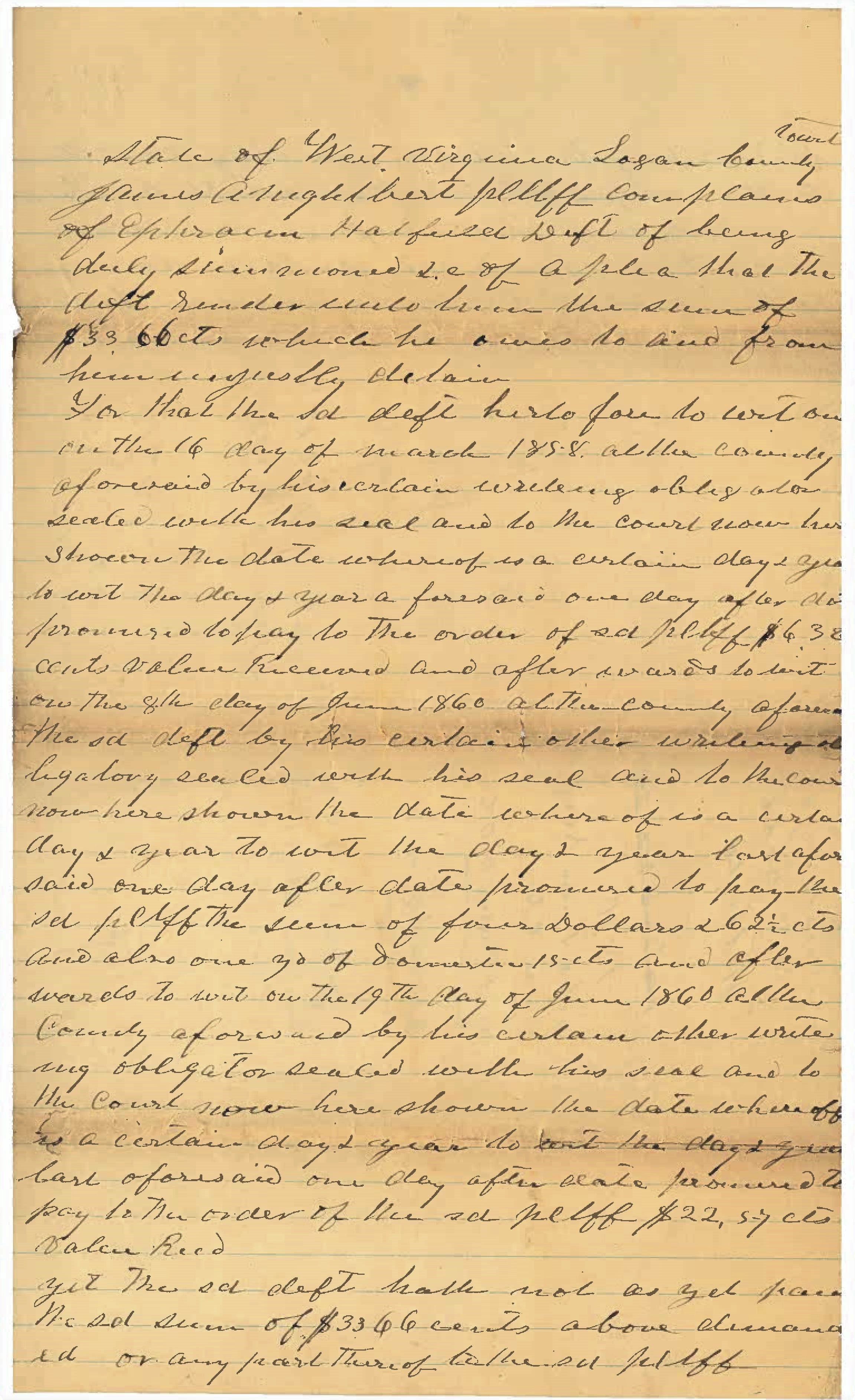
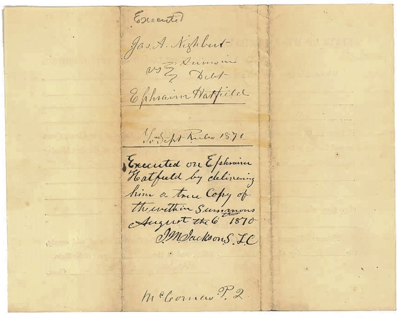
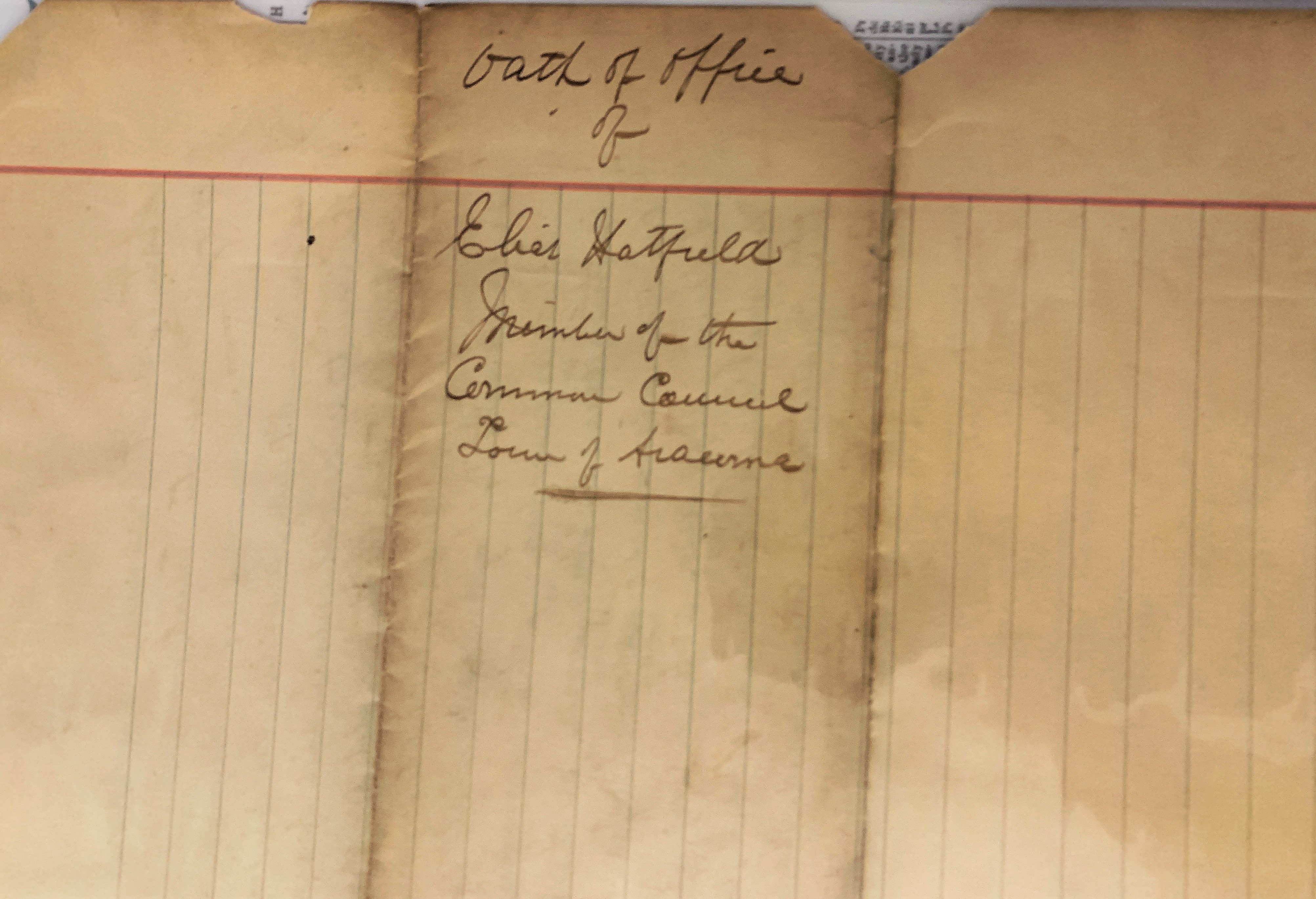
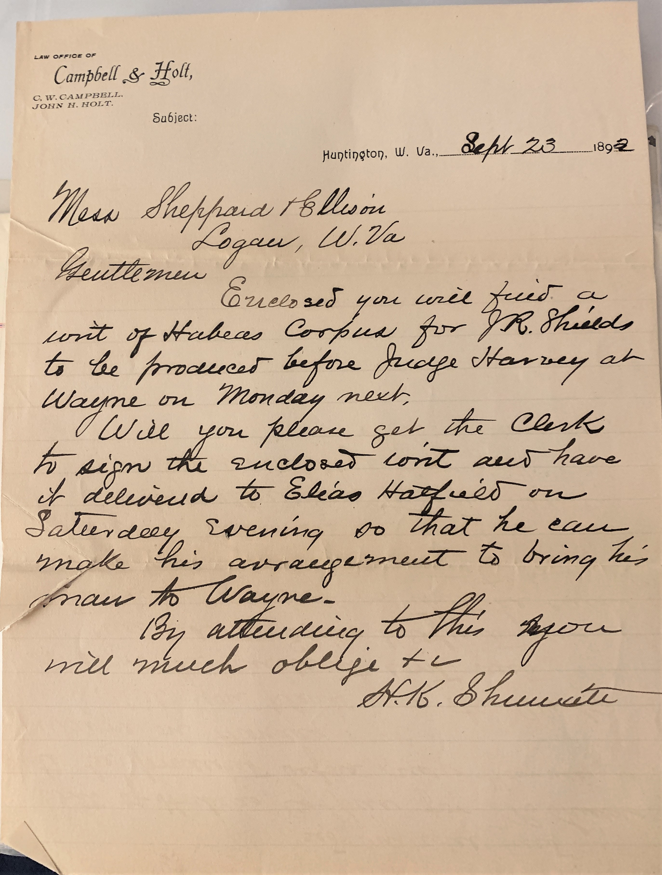
Posted in Hatfield-McCoy Feud, Huntington, Logan, Wayne
Tags
Appalachia, attorney, C.W. Campbell, Elias Hatfield, genealogy, H.K. Shumate, Hatfield-McCoy Feud, history, Huntington, J.R. Shields, John H. Holt, judge, Logan County, Thomas H. Harvey, Wayne County, West Virginia
16 Tuesday Feb 2021
Posted in Big Sandy Valley, Hatfield-McCoy Feud, Matewan
Tags
Appalachia, Double Camp Branch, Ellison Hatfield, Ephraim Hatfield, genealogy, H.R. Phillips, Hatfield-McCoy Feud, history, Logan County, Magnolia District, Mates Creek, Mingo County, West Virginia
The following land information is derived from Land Book 1880-1886, Land Book 1887-1892, and Land Book 1893-1899 at the Logan County Clerk’s Office in Logan, WV:
Ellison Hatfield
No property listed in 1865-1879.
1880: Magnolia District
50 acres Double Camp Fork, Ben Creek $0.25 per acre no building $12.50
300 acres Mates Creek $0.25 per acre no building $75 total
[Note: The 300-acre tract was transferred from Ephraim Hatfield.]
1881: Magnolia District
50 acres Double Camp Fork Mates Creek $0.25 per acre no building $12 total
276 acres Mates Creek $0.25 per acre no building $69 total
[Note: The reduction of the 300-acre tract is unexplained.]
1882: Magnolia District
The Hatfield page is missing.
1883: Magnolia District
No records are listed for this year.
1884: Magnolia District
50 acres Double Camp Br. Mates Creek $2.50 per acre $25 building $125 total
276 acres Double Camp Br. Mates Creek $1 per acre no building $276 total
20 acres Double Camp Mates Creek $1 per acre no building $20 total
[Note: The 50-acre and 276-acre tract is listed in the name of “Ellison Hatfield’s Heirs”. The 20-acre tract is listed in the name of Ellison Hatfield.]
1885: Magnolia District
50 acres Double Camp Branch, Mates Creek $2.50 per acre $25 building $125 total
276 acres Double Camp Branch, Mates Creek $1 per acre no building $276 total
50 acres Double Camp Branch, Mates Creek $2.50 per acre $30 building $125 total
1886: Magnolia District
50 acres Mates Creek $2.50 per acre no building $56 total
20 acres Mates Creek $1 per acre no building $130 total
1887-1889: Magnolia District
Ellison Hatfield
50 acres Mates Creek $2.50 per acre $30 building $125 total
20 acres Mates Creek $1 per acre no building $20 total
Ellison Hatfield’s Heirs
50 acres Double Camp, Mates Creek $2.50 per acre $25 building $125 total
276 acres Double Camp, Mates Creek $1 per acre no building $276 total
20 acres Double Camp, Mates Creek $1 per acre no building $20 total
[Note: In 1887, the latter three tracts are noted as “one yr back tax & interest.” In 1888, the latter three tracts are noted as “sold to Okeefe for tax.” In 1889, the latter three tracts are restored to Ellison Hatfield’s heirs.]
1890-1891: Magnolia District
Ellison Hatfield
50 acres Mates Creek $2.50 per acre $30 building $125 total
20 acres Mates Creek $1 per acre no building $20 total
Ellison Hatfield’s Heirs
50 acres Double Camp, Mates Creek $2.50 per acre $25 building $125 total
276 acres Double Camp, Mates Creek $1 per acre no building $276 total
28 acres Double Camp, Mates Creek $1 per acre no building $28 total
1892: Magnolia District
Ellison Hatfield
50 acres Mates Creek $2.50 per acre $25 building $125 total
20 acres Mates Creek $2 per acre $40 building $175 total
Ellison Hatfield’s Heirs
50 acres Double Camp, Mates Creek $3.50 per acre $30 building $175 total
276 acres Double Camp, Mates Creek $3.50 per acre no building $966 total
28 acres Double Camp, Mates Creek $3.50 per acre no building $98 total
1893: Magnolia District
Ellison Hatfield
50 acres Mates Creek $2.50 per acre $30 building $125 total
20 acres Mates Creek $2 per acre no building $40 total
[In 1893, Ellison Hatfield’s heirs by commissioner transferred 250 acres on Mates Creek worth $3.50 per acre and total value of $875 to H.R. Phillips, trustee.]
16 Tuesday Feb 2021
Posted in Big Sandy Valley, Hatfield-McCoy Feud
Tags
Appalachia, Big Sandy River, Elias Hatfield, feuds, fiddle, Floyd Hatfield, Hatfield-McCoy Feud, history, Johnse Hatfield, Kentucky, Randolph McCoy, Roseanna McCoy, Tolbert McCoy, Tug Fork, West Virginia


15 Monday Feb 2021
Posted in Big Sandy Valley, Hatfield-McCoy Feud, Matewan
Tags
Appalachia, Ephraim Hatfield, genealogy, Hatfield-McCoy Feud, history, Logan County, Magnolia District, Marks Branch, Mates Creek, Mingo County, Nancy Hatfield, Patterson Hatfield, Smith Hatfield, West Virginia
The following land information is derived from Land Book 1873-1874, Land Book 1880-1886, and Land Book 1893-1899 at the Logan County Clerk’s Office in Logan, WV:
Smith and Patterson Hatfield
No property listed in 1865-1877.
1878: Magnolia District
Smith and Patterson Hatfield
100 acres Mates Creek $4 per acre $25 building $400 total
[Note: This tract was transferred from Ephraim Hatfield in 1878.]
Smith Hatfield
25 acres Marks Branch, Mates Creek $0.20 per acre no building $5 total
1879: Magnolia District
No records for this year.
1880-1881: Magnolia District
Smith and Patterson Hatfield
100 acres Mates Creek $4 per acre $25 building $400 total
Smith Hatfield
25 acres Marks Branch, Mates Creek $0.20 per acre no building $5 total
[Note: In the 1880 census, widowed Nancy Hatfield lived with her son, Patterson.]
1882: Magnolia District
The Hatfield page is missing.
1883: Magnolia District
The page is mostly blank but does list:
Smith Hatfield 25 acres M__ Br of Mates Creek $2.50 per acre [rest is blank]
1884-1885: Magnolia District
Smith and Patterson Hatfield
100 acres Mates Creek $3 per acre $35 building $300 total
Smith Hatfield
25 acres Marks Br. of Mates Creek $2.50 per acre no building $62.50 total
1886: Magnolia District
Smith and Patterson Hatfield
100 acres Mates Creek $3 per acre no building $230 total
Smith Hatfield
25 acres Mack Branch, Mates Creek $2.50 per acre [blank]
1887-1888: Magnolia District
Smith and Patterson Hatfield
100 acres Mates Creek $3 per acre $35 building $300 total
Smith Hatfield
25 acres Marks Branch, Mates Creek $2.50 per acre no building $62.50 total
1889: Magnolia District
Smith Hatfield
25 acres Mark Branch, Mate Creek $2.50 per acre no building $65 total
Pat Hatfield
50 acres Mates Creek $3 per acre $35 building $150 total
1890: Magnolia District
Smith Hatfield
25 acres Mate Creek $2.50 per acre no building $65 total
50 acres Mate Creek $3 per acre $35 building $150 total
Patterson Hatfield
50 acres Mate Creek $3 per acre $30 building $150 total
1891-1892: Magnolia District
Smith Hatfield
25 acres Mate Creek $2.50 per acre no building $62.50 total
50 acres Mate Creek $3 per acre $35 building $150 total
Patterson Hatfield
50 acres Mate Creek $3 per acre $30 building $150 total
1893-1894: Magnolia District
Smith Hatfield
25 acres Mate Creek $2.50 per acre no building $62.50 total
50 acres Mate Creek $3 per acre $40 building $150 total
Patterson Hatfield
50 acres Mate Creek $2.50 per acre $40 building $125 total
13 Saturday Feb 2021
Posted in Big Sandy Valley, Hatfield-McCoy Feud
Tags
Appalachia, Beech Creek, Big Sandy River, Doc Mahon, Double Camp Branch, Ephraim Hatfield, genealogy, Hatfield-McCoy Feud, history, J.D. Sergeant, Jane Hatfield, Logan County, Magnolia District, Mingo County, Philadelphia, Valentine Wall Hatfield, West Virginia
The following land information is derived from Land Book 1873-1874, Land Book 1880-1886, Land Book 1887-1892, and Land Book 1893-1899 at the Logan County Clerk’s Office in Logan, WV:
Valentine Hatfield
No property listed in 1865-1873.
1874: Magnolia District
84 acres Beech Creek, Sandy River $5.25 per acre no building $441 total
144 acres Double Camp Branch, Beech $0.10 per acre no building $14.40 total
[Note: Regarding the latter tract, the book reads “entered on Books and corrected.”]
1875: Magnolia District
84 acres Beech Creek, Sandy River $5.25 per acre no building $441 total
144 acres Double Camp Branch, Beech $0.25 per acre no building $36 total
1876: Magnolia District
84 acres Beech Creek, Sandy River $5.25 per acre no building $441 total
144 acres Double Camp Branch, Beech $0.10 per acre no building $14.40 total
1877: Magnolia District
The record is blank.
1878: Magnolia District
48 acres Beech Creek $5.25 per acre no building $141 total
144 acres Double Camp Branch, Beech Creek $0.25 per acre no building $36 total
1879: Magnolia District
No records for this year.
1880-1881: Magnolia District
84 acres Beech Creek $5.25 per acre no building $441 total
144 acres Double Camp and Mates Creek $0.25 per acre no building $36 total
1882: Magnolia District
The Hatfield page is missing
1883: Magnolia District
The record is blank for this year.
1884-1885: Magnolia District
84 acres Beech Creek, Sandy River $5 per acre $50 building $420 total
144 acres Double Camp, Sandy River $1 per acre no building $144 total
1886: Magnolia District
84 acres Beech Creek, Sandy River $5 per acre $15 building $125 total
114 acres Double Camp, Sandy River $1 per acre $75 building $280 total
1887: Magnolia District
84 acres Beech Creek $5 per acre $50 building $420 total
144 acres Double Camp, Mates Creek $1 per acre no building $144 total
1888: Magnolia District
44 acres Beech Creek $5 per acre $50 building $220 total
144 acres Beech Creek $1 per acre no building $144 total
[Note: In this year, Wall Hatfield transferred 40 acres of the 84-acre tract to Doc Mahon.]
1889: Magnolia District
No property listed.
[In 1889, he transferred 89 acres on Beech Creek worth $1 per acre and total value of $89 to Ephraim Hatfield. Also, transferred with others 126 acres on Beech Creek worth $1 per acre and total value of $126 to J.D. Sergeant of Philadelphia.]
1890: Magnolia District
No property listed.
[Note: Wall Hatfield died on February 13, 1890 at Frankfort, KY.]
1891: Magnolia District
Jane Hatfield
84 acres, Beech Creek, $2 per acre, no building, $168 total
[Note: “Entered with 1 yr B tax.”]
1892-1893: Magnolia District
Jane Hatfield
84 acres, Beech Creek, $2.50 per acre, $40 building, $210 total
12 Friday Feb 2021
Posted in Big Sandy Valley, Guyandotte River, Hatfield-McCoy Feud, Logan, Matewan
Tags
Appalachia, Big Island, Big Sandy River, E.K. Counts, Elias Hatfield, genealogy, George W. Duty, Hardee District, Hatfield-McCoy Feud, history, Logan County, Logan County Banner, Logan District, Magnolia District, Magnolia Township, Mates Creek, Mingo County, Oliver Perry, Warren Alderson, West Virginia
The following land information is derived from Land Book 1866-1872, Land Book 1873-1874, Land Book 1880-1886, Land Book 1887-1892 , and Land Book 1893-1899 at the Logan County Clerk’s Office in Logan, WV:
Elias Hatfield
No property listed in 1865-1868.
1869-1870: Magnolia Township
100 acres Mates Creek $4.00 per acre no building $400 total from E.K. Counts
30 acres Mates Creek $10 per acre no building $300 total from E.K. Counts
50 acres Mates Creek $20 per acre no building $1000 total from E.K. Counts
1871: Magnolia Township
100 acres Mates Creek $3.00 per acre $50 building $300 total
30 acres Mates Creek $3.00 per acre no building $90 total
50 acres Mates Creek $3.00 per acre no building $150 total
1872: Magnolia Township
100 acres Mates Creek $3.00 per acre $50 building $300 total
30 acres Mates Creek $3.00 per acre no building $90 total
50 acres Mates Creek $3.00 per acre no building $150 total
50 acres Mates Creek $3.00 per acre no building $150 total
350 acres Mates Creek $0.25 per acre no building $87.50 total from W. Alderson (assessor)
1873: Magnolia District
100 acres Mates Creek $3.00 per acre no building $300 total
30 acres Mates Creek $3.00 per acre no building $40 total
50 acres Mates Creek $3 per acre no building $150 total
400 acres Two Tracts Mates Creek $1 per acre no building $400 total
50 acres Mates Creek $3 per acre no building $150 total
350 acres Mates Creek $0.25 per acre no building $87.50 total
1874: Magnolia District
100 acres Mates Creek $3.00 per acre $50 building $300 total
50 acres Mates Creek $3 per acre no building $150 total
30 acres Mates Creek $3.00 per acre no building $40 total
400 acres Two Tracts Mates Creek $1 per acre no building $400 total
50 acres Mates Creek $3 per acre no building $150 total
350 acres Mates Creek $0.25 per acre no building $87.50 total
1875-1876: Magnolia District
100 acres Mates Creek $3.00 per acre $50 building $300 total
50 acres Mates Creek $3 per acre no building $150 total
30 acres Mates Creek $3.00 per acre no building $40 total
400 acres Two Tracts Mates Creek $1 per acre no building $400 total
50 acres Mates Creek $3 per acre no building $150 total
[Note: In 1875, Elias transferred his 350-acre tract but records do not identify the recipient.]
1877: Magnolia District
Records are blank for this district.
1878: Magnolia District
100 acres Mates Creek $3 per acre $50 building $300 total
30 acres Mates Creek $3 per acre $90 building $90 total
400 acres 2 Tracts, Mates Creek $0.25 per acre no building $100 total
50 acres Mates Creek $2 per acre no building $100 total
[Note: Records for this year spelled his name as Allias Hatfield.]
1879: Magnolia District
Records are missing for this year
1880: Magnolia District
100 acres Mates Creek $3 per acre $50 building $300 total
30 acres Mates Creek $3 per acre $90 building $90 total
400 acres 2 Tracts, Mates Creek $0.25 per acre no building $100 total
50 acres Mates Creek $2 per acre no building $100 total
1881: Magnolia District
100 acres Mates Creek $3 per acre no building $300 total
30 acres Mates Creek $3 per acre no building $90 total
400 acres 2 Tracts, Mates Creek $0.25 per acre no building $100 total
50 acres Mates Creek $2 per acre no building $100 total
[Note: The 100-acre tract was noted with this: “yrs from G.W. Duty.” The 30 acre tract was noted as “change to Hardee Dist on Book 1882.”]
1882: Magnolia District
The Hatfield page is missing.
1883: Magnolia District
The record is blank for this district
1884: Magnolia District
100 acres Mates Creek $3 per acre $50 building $300 total
30 acres Mates Creek $4 per acre $30 building $120 total
400 acres 2 Tracts, Mates Creek $1 per acre no building $400 total
50 acres Mates Creek $3 per acre no building $150 total
1885: Magnolia District
100 acres Mates Creek $3 per acre $50 building $300 total
30 acres Mates Creek $4 per acre $30 building $120 total
400 acres 2 Tracts, Mates Creek $1 per acre no building $400 total
50 acres Mates Creek $3 per acre no building $150 total
749 acres Mates Creek $1 per acre no building $749
322 acres Mates Creek $1 per acre no building $322 total
[In 1885, he acquired the 749-acre tract from a commissioner. No indication is given about the source of the 322 acres.]
1886: Magnolia District
100 acres Mates Creek $3 per acre [blank]
30 acres Mates Creek $4 per acre [blank]
50 acres Mates Creek $3 per acre [blank]
1471 acres 4 Tracts Mates Creek $1 per acre [blank]
600 acres Sandy River $1.90 per acre no building $56 total
1887: Magnolia District
100 acres Mates Creek $3 per acre $50 building $300 total
30 acres Mates Creek $4 per acre $30 building $120 total
50 acres Mates Creek $3 per acre no building $150 total
1471 acres 4 Tracts, Mates Creek $1 per acre no building $1471 total
600 acres Sandy River $1.90 per acre $40 building $1140 total
1888: Magnolia District
600 acres Sandy River $1.90 per acre $40 building $1140 total
1889-1891: Magnolia District
600 acres Sandy River $1.90 per acre $40 building $1140 total
1889-1891: Logan District
30 acres Big Island $20 per acre no building $600 total
13 acres Big Island and Washed Part $1 per acre no building $13 total
[Note: The 30-acre tract was acquired from Oliver Perry. No indication of the source for the 13 acres. According to the 21 March 1889 issue of the Logan County Banner: “On the 18th inst., Elias Hatfield, purchased of Oliver Perry, the property known as the ‘Big Island’ near this place.”]
1892-1894: Magnolia District
400 acres Sandy River $5 per acre $50 building $2000 total
1892-1894: Logan District
25 acres Big Island Guyandotte River $20 per acre no building $500 total
18 acres Big Island Guyandotte River $1 per acre no building $18 total
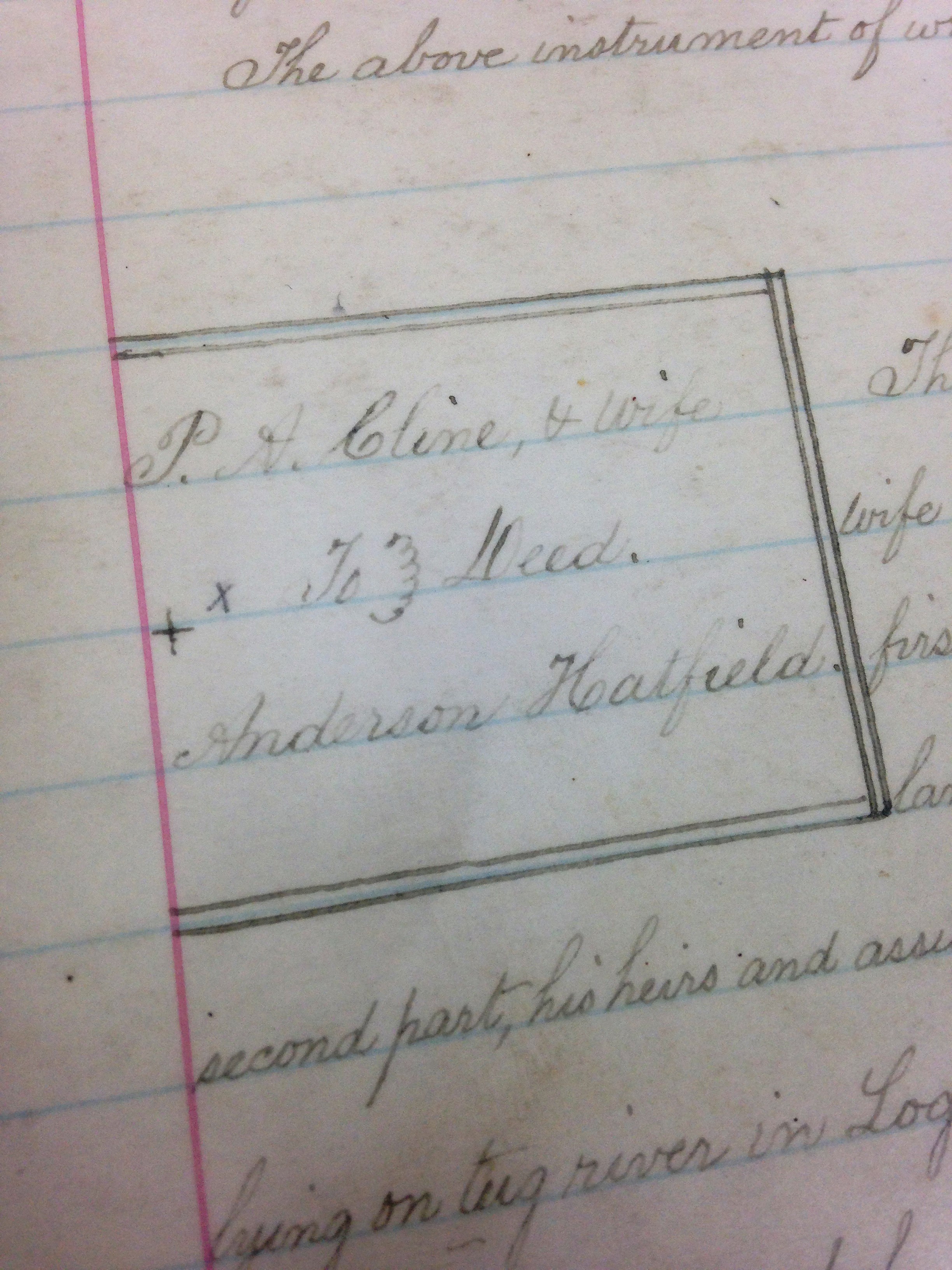
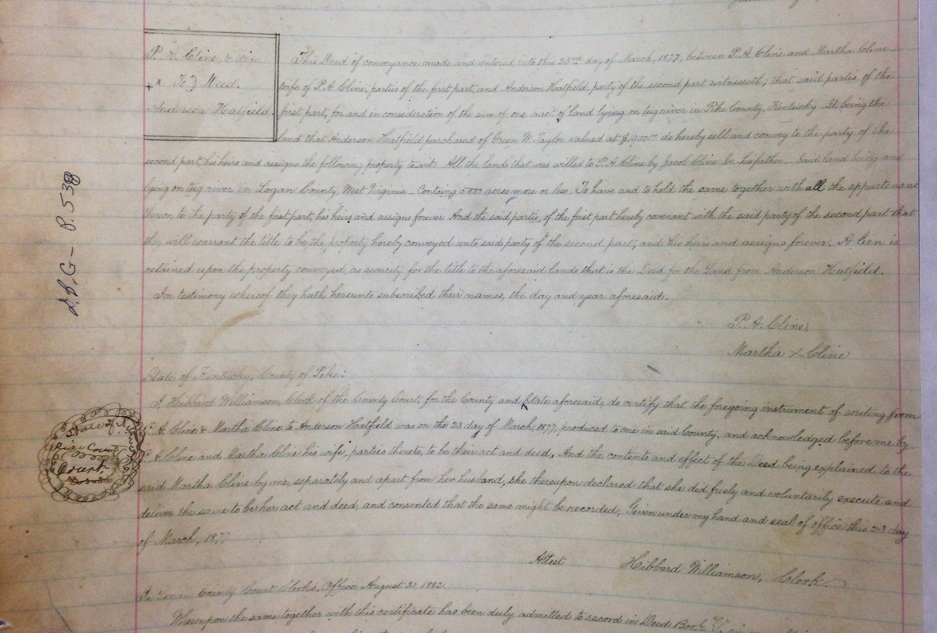
12 Friday Feb 2021
Posted in Big Sandy Valley, Hatfield-McCoy Feud
Tags
Devil Anse Hatfield, genealogy, Green W. Taylor, Hatfield-McCoy Feud, history, Jacob Cline Sr., Kentucky, Logan County, Martha Cline, Perry Cline, Pike County, Tug River, West Virginia
11 Thursday Feb 2021
Posted in Big Sandy Valley, Hatfield-McCoy Feud, Matewan
Tags
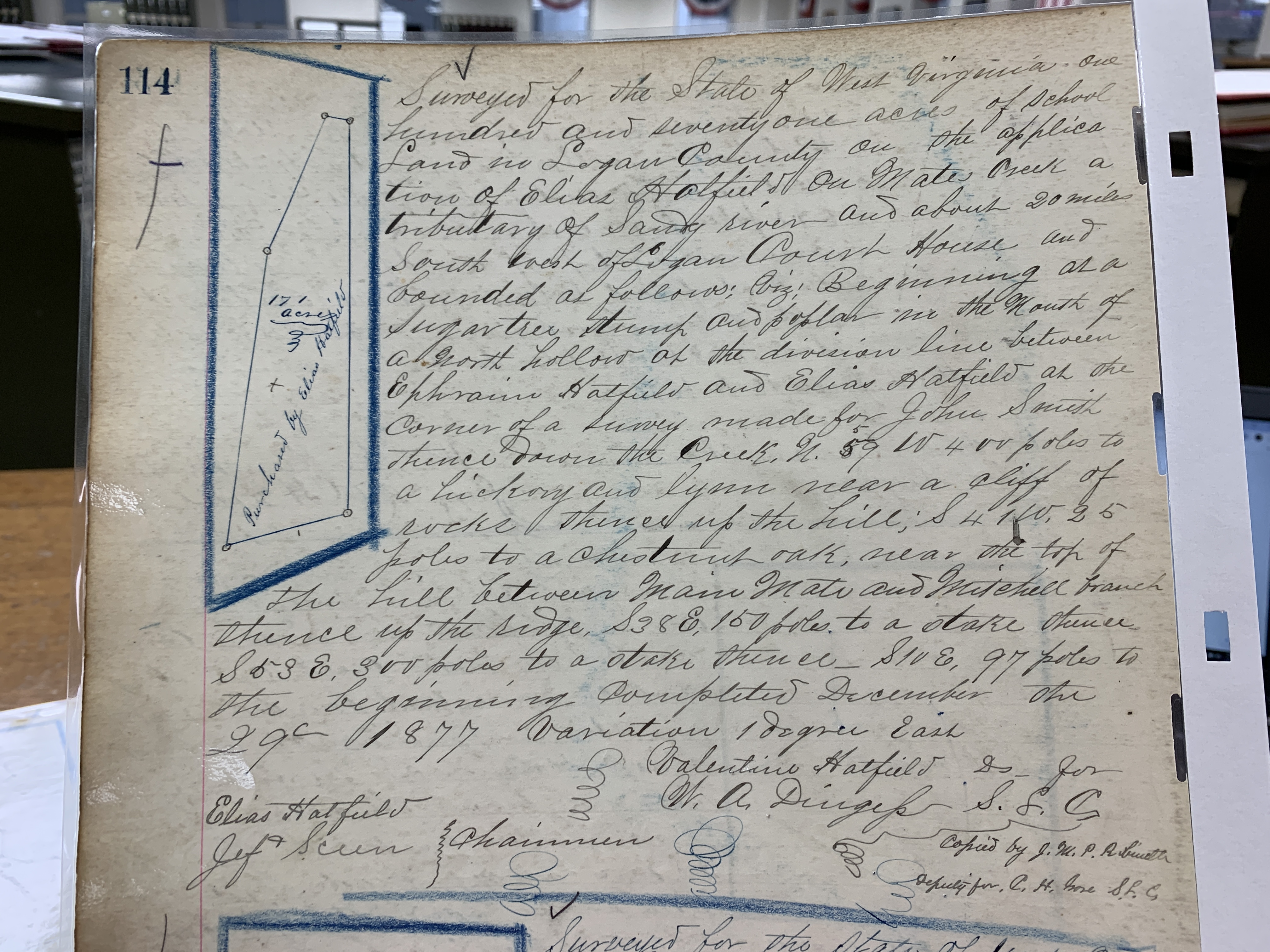
Appalachia, Big Sandy River, Elias Hatfield, Ephraim Hatfield, Hatfield-McCoy Feud, history, John Smith, Logan County, Mates Creek, Mingo County, Mitchell Branch, Valentine Wall Hatfield, W.A. Dingess, West Virginia
02 Tuesday Feb 2021
Posted in Big Sandy Valley, Hatfield-McCoy Feud, Matewan
Tags
Appalachia, Beech Creek, Big Sandy River, Double Camp Branch, Ephraim Hatfield, genealogy, Hatfield-McCoy Feud, history, Lewis Ferrell, Logan County, Magnolia District, Magnolia Township, Mates Creek, Meador Branch, Mingo County, Murphys Branch, Nancy Varney, Patterson Hatfield, Smith Hatfield, Straight Fork, Valentine Wall Hatfield, West Virginia
The following land information is derived from Land Book 1866-1872, Land Book 1873-1874, Land Book 1880-1886, and Land Book 1887-1892 at the Logan County Clerk’s Office in Logan, WV:
Ephraim Hatfield
1865-1867: Magnolia Township
70 acres Murphys Branch, Mate Creek $0.50 per acre no building $35 total
125 acres Meadors Branch, Mate Creek $0.50 per acre no building $62.50 total
115 acres Mate Creek $6.00 $200 building $690 total
45 acres Double Camp $2.00 no building $90 total
20 acres South Side, Mate Creek [added in 1871, five years back tax]
24 acres Straight Fork $3.00 per acre no building $72 total
84 acres Beech Creek $5.00 per acre no building $420 total
1868: Magnolia Township
The book contains no entries for Magnolia Township)
1869-1872: Magnolia Township
70 acres John Murpheys Branch, Mate Creek $0.52 per acre no building $36.75 total
[125-acre tract was gone by 1869, bestowed to Nancy Varney, who had 125 acres on “Meadow” Branch worth $0.52 1/2 in 1869]
115 acres Mate Creek $6.30 per acre $200 building $724.50 total
45 acres Double Camp $2.10 per acre no building $94.50 total
20 acres South Side, Mate Creek $0.52 1/2 per acre no building $10.50 total
24 acres Straight Fork $3.15 per acre no building $75.60 total
84 acres Beech Creek $5.25 per acre no building $441 total
1873: Magnolia District
70 acres John Murpheys Branch, Mate Creek $0.52 per acre no building $36.75 total
[Note: The above building was likely noted in error.]
113 acres Mate Creek $6.30 per acre $200 building $724.50 total
[Note: The 115-acre tract is likely noted as 113 acres in error.]
45 acres Double Camp $2.10 per acre no building $94.50 total
20 acres South Side, Mate Creek $0.52 1/2 per acre no building $10.50 total
24 acres Straight Fork $3.15 per acre no building $75.60 total
84 acres Beech Creek $5.25 per acre no building $441 total
1874: Magnolia District
115 acres Mates Creek $6.30 per acre $200 building $724.50 total
45 acres Double Camp $2.10 per acre no building $94.50 total
20 acres S Side Mate Creek $0.52 per acre 1/2 no building $10.50 total
24 acres Trough? Fork $0.15? per acre no building $75.60 total
[Note: He transferred the 84-acre tract to Valentine Hatfield]
1875: Magnolia District
115 acres Mates Creek $4.00 per acre $45 building $460 total
45 acres Double Camp of Mates Creek $0.25 per acre no building $11.25 total
20 acres Double Camp $0.25 per acre no building $5.00 total
24 acres Strat Fork $0.25 per acre no building $6.00 total
1876: Magnolia District
115 acres Mate Creek $0.25 per acre no building $11.25 total
45 acres Double Camp Mates Creek $0.25 per acre no building $5.00 total
20 acres Double Camp Mates Creek $0.25 per acre no building $6.00 total
24 acres Straight Fork $0.25 per acre no building $18.75 total
1877: Magnolia District
Records are missing for this year.
1878: Magnolia District
15 acres Mates Creek $4.00 per acre $25 building $60 total
20 acres Double Camp Branch Mate Creek $0.25 per acre no building $5.00 total
24 acres Strate Fork Mate Creek $0.25 per acre no building $6.00 total
368 acres Mates Creek $0.10 per acre no building $36.80 total
[Note: In 1878, Ephraim transferred one tract of 100 acres on Mate Creek worth four dollars per acre containing a $25 building with a total worth of $400 to Smith and Patterson Hatfield. He also transferred one tract of 50 acres on Nashes Buck? Hollow Double Camp worth twenty-five cents per acre with no building and total worth of $12.50 to Floyd Hatfield.]
1879: Magnolia District
Records are missing for this year.
1880: Magnolia District
15 acres Mates Creek $4.00 per acre $25 building $60 total
20 acres Double Camp Branch Mate Creek $0.25 per acre no building $5.00 total
24 acres Strate Fork Mate Creek $0.25 per acre no building $6.00 total
68 acres Mates Creek $0.10 per acre no building $36.80 total
[Note: In 1880, Ephraim transferred 300 acres from the 368-acre tract to Ellison Hatfield. Note also that he died before the 1880 census.]
1881: Magnolia District
15 acres Mates Creek $4.00 per acre $25 building $375.00? total
20 acres Double Camp Branch Mate Creek $0.25 per acre no building $99.00 total
24 acres Strate Fork Mate Creek $0.25 per acre no building $200.00
68 acres Mates Creek $0.25 per acre no building $109.00
[Note errors in total valuation for his property.]
1882: Magnolia District
The Hatfield page is missing from records.
1883: Magnolia District
Records are missing for this year.
1884: Magnolia District
15 acres Mates Creek $5.00 per acre $40 building $75 total
20 acres Double Camp Branch $1 per acre no building $20 total
68 acres Mates Creek $1 per acre no building $68 total
[Note: The 50-acre tract was listed under Ephraim, Sr. and was transferred from Floyd Hatfield. The 114-acre tract was transferred from a commissioner.]
1885: Magnolia District
15 acres Mates Creek $5 per acre $40 building $75 total
20 acres Double Camp Branch, Mates Creek $1 per acre no building $20 total
68 acres Mates Creek $1 per acre no building $68 total
1886-1888: Magnolia District
No property is listed for 1886, 1887, and 1888.
02 Saturday Jan 2021
Posted in Big Sandy Valley, Civil War, Hatfield-McCoy Feud, Women's History
Tags
attorney general, Battle of Gravepine, Battle of Scary Creek, Cap Hatfield, Charleston, civil war, Confederate Army, crime, Dan Cunningham, detective, Devil Anse Hatfield, Ellison Mounts, feuds, Frank Phillips, Hatfield-McCoy Feud, Howard B. Lee, Jim Comstock, Johnse Hatfeild, Kentucky, Logan Wildcats, Nancy Hatfield, Roseanna McCoy, Tug Fork, Union Army, West Virginia, West Virginia Women
Howard B. Lee, former Attorney General of West Virginia, provided this account of Nancy Hatfield (widow of Cap) in the early 1970s:
Our next stop was at the home of Nancy Elizabeth, the same home where I visited with her and Cap during my campaign. For nearly three hours I asked questions and listened to that remarkable woman recount many of her experiences as the wife of America’s most celebrated feudist.
Nancy Elizabeth’s home also held a number of guns, pistols, and other relics of the feud days. But the most interesting item was Cap’s bullet-proof, steel breastplate, designed to cover the entire front half of his body from his beck to his lower abdomen.
“Mrs. Hatfield,” I said, “judging from the three bullet marks on it, this breastplate was a great protection to Cap; but what was to prevent an enemy from shooting him in the back?” Her eyes flashed as she replied: “Mr. Lee, Cap Hatfield never turned his back on an enemy or a friend.”
“I have read two stories, Mrs. Hatfield, each purporting to give the true cause of the feud: One book stated that it was the result of a dispute between a McCoy and a Hatfield over the ownership of a hog. Another book said that it grew out of the seduction of a McCoy girl by Johnson Hatfield, oldest son of Devil Anse. Is either one of these stories true?”
“No, neither story is true,” she replied. “The McCoys lived on the Kentucky side of Tug River, and the Hatfields lived on the West Virginia side. Hogs don’t swim rivers. I never heard the girl story until I read it in a book, written long after the feud was over. Both stories are pure fiction.”
“The truth is,” she continued, “in the fall of 1882, in an election-day fight between Ellison Hatfield, a younger brother of Devil Anse, and three McCoy brothers, Ellison was shot and knifed. He died two days later. In retaliation, Devil Anse and his clan captured and shot the three McCoy brothers. It was these four senseless killings that started the feud.”
In answer to my inquiry, Nancy Elizabeth said: “Yes, there had been ‘bad blood’ between the two families since the Civil War. In that struggle the Hatfields were ‘rebels’,–loyal to their State, Virginia. Devil Anse organized and was the captain of a company of Confederate sympathizers called the ‘Logan Wildcats’. They were recruited for local defense; but they left the county long enough to take part in the battle of Scary, fought along the banks of the Kanawha River, a few miles below Charleston.
“The McCoys, and their mountain neighbors, were pro-Union; and to protect their region against invasion by ‘Virginia rebels’, they organized a military company called ‘Home Guards’. There were occasional border clashes between the two forces, with casualties on both sides. The war ended only seventeen years before the feud began, and the bitterness still existed in the minds of the older generation, and they passed it on to their children. It was the old sectional and political hatreds that sparked the fight between Ellison Hatfield and the McCoy brothers.”
Nancy Elizabeth declined to estimate the number killed on either side of the feud.
“It was a horrible nightmare to me,” she said. “Sometimes, for months, Cap never spent a night in our house. He and Devil Anse, with others, slept in the nearby woods to guard our homes against surprise attacks. At times, too, we women and our children slept in hidden shelters in the forests.
“But these assaults were not one-sided affairs. The Hatfields crossed the Tug and killed McCoys. It was a savage war of extermination, regardless of age or sex. Finally, to get our children to a safer locality, we Hatfields left Tug River, crossed the mountains, and settled here on Island Creek, a tributary of the Guyandotte River.
“No, there was no formal truce ending hostilities. After a decade or more of fighting and killing, both sides grew tired and quit. The McCoys stayed in Kentucky and the Hatfields kept to West Virginia. The feud was really over a long time before either side realized it.
“Yes, Kentucky offered a large reward for the capture of Devil Anse and Cap. The governor of West Virginia refused to extradite them because, said he, ‘their trials in Kentucky would be nothing more than legalized lynchings’. It was then that Kentucky’s governor offered the reward for their capture–‘dead or alive’. Three attempts were made by reward seekers to capture them.
“Dan Cunningham, a Charleston detective, with two Cincinnati detectives, made the first attempt. They came through Kentucky, and crossed Tug River in the night; but the Hatfields soon captured them. A justice of the peace sentenced them to 90 days in Logan County jail for disturbing hte peace. When released, they were told to follow the Guyandotte River to Huntington, a distance of 60 miles, and ‘not to come back’.
“Next, a man named Phillips led two raids from Kentucky into Hatfield territory. In the first, he captured ‘Cottontop’ Mounts, a relative and supporter of the Hatfields, and took him to Pikeville, Kentucky, where he was hanged. But the second foray met with disaster at the ‘Battle of the Grapevine’. Phillips, and some of his followers escaped into Kentucky, but some where buried where they fell.
“This was the last attempt of the reward seekers. However, Kentucky never withdrew the reward offer, and that is why Devil Anse and Cap were always alarmed and on the alert.”
Source: West Virginia Women (Richwood, WV: Jim Comstock, 1974), p. 151-152
28 Monday Dec 2020
Posted in Cemeteries, Hatfield-McCoy Feud, Logan, Women's History
Tags
Appalachia, attorney general, Betty Caldwell, Cap Hatfield, cemeteries, Devil Anse Hatfield, feuds, Hatfield-McCoy Feud, history, Howard B. Lee, Jim Comstock, Logan, Logan County, Nancy Hatfield, politics, Republican Party, Robert Elliott Hatfield, Sarah Ann, Tennis Hatfield, West Virginia, West Virginia Women, Willis Hatfield
Howard B. Lee, former Attorney General of West Virginia, provided this account of Nancy Hatfield (widow of Cap) in the early 1970s:
HATFIELD WOMEN.
Over the years, much has been written about the male members of the Hatfield clan who took part in that early orgy of blood-letting–the Hatfield-McCoy feud. But nothing has been said concerning the indomitable wives of that stalwart breed of men.
My purpose is to pay a richly deserved tribute to one of those pioneer women–the late Nancy Elizabeth, wife of William Anderson Hatfield, common known “Cap,” second son of Devil Anse, and the most deadly killer of the feud.
More than 30 years have passed since I last talked with her; but I still regard Nancy Elizabeth Hatfield as the most remarkable and unforgettable woman of the mountains.
In the spring of 1924, I was a candidate in the primary election for the Republican nomination for attorney general, and I wanted the Hatfield influence. Devil Anse had died in 1921, and his mantle of leadership of the clan had fallen to his oldest living son, Cap–a power in Logan County politics.
I had met Cap, casually, in 1912, but I had not seen him since that meeting. But his sister, Mrs. Betty Caldwell, and her husband, lived in my county of Mercer, and were among my political supporters. To pave the way for my later meeting with Cap, I had Mrs. Caldwell write and ask him to support me.
Later, when campaigning in the City of Logan, I engaged a taxi to take me the few miles up Island Creek to Cap’s home. The car stopped suddenly and the driver pointed to a comfortable-looking farm house on the other side of the creek and said:
“That’s Cap’s home, and that’s Cap out there by the barn.”
I told him to return for me in two hours.
Cap saw me get out of the car, and, as I crossed the creek on an old-fashioned footlog. I saw him fold his arms across his chest and slip his right hand under his coat. Later, I noticed a large pistol holstered under his left arm. Even in that late day, Cap took no chances with strangers. When I got within speaking distance, I told him my name, and that I had come to solicit his support in my campaign for attorney general. He gave me a hearty handclasp, and said:
“My sister, Mrs. Caldwell, wrote us about you. But, let’s go to the house, my wife is the politician in our family.”
Cap was reluctant to commit himself “so early.” But Nancy Elizabeth thought otherwise. Finally, Cap agreed to support me; and, with that point settled, we visited until my taxi returned.
Meanwhile, with Cap’s approval, Nancy Elizabeth gave me the accompanying, heretofore unpublished photograph of the Devil Anse Clan. In 1963 I rephotographed it and sent a print to Willis Hatfield (number 22 in picture), only survivor of Devil Anse, who made the identification. Nancy Elizabeth is number 16, and the baby in her lap is her son, Robert Elliott, born April 29, 1897. Therefore, the photograph must have been made late in 1897, or early in 1898.
A few months after Cap’s death (August 22, 1930), the West Virginia newspaper publishers and editors held their annual convention in Logan. I was invited to address the group at a morning session. That same day, Sheriff Joe Hatfield and his brother, Tennis, younger brothers of Cap, gave an ox-roast dinner for the visiting newsmen and their guests. The picnic was held on a narrow strip of bottom land, on Island Creek, a half-mile below the old home of Devil Anse.
I ate lunch with Nancy Elizabeth and her sister-in-law, Betty Caldwell. After lunch, at the suggestion of Mrs. Caldwell, we three drove up the creek to the old home of her father–Devil Anse. It was a large, two-story, frame structure (since destroyed by fire, then occupied by Tennis Hatfield, youngest son of Devil Anse).
The most interesting feature in the old home was Devil Anse’s gun-room. Hanging along its walls were a dozen, or more, high-powered rifles, and a number of large caliber pistols, ranging from teh earliest to the latest models. “The older guns,” said Nancy Elizabeth, “were used in the feud.”
As we returned, we stopped at the family cemetery that clings uncertainly to the steep mountainside, overlooking the picnic grounds. There, among the mountains he loved and ruled, old Devil Anse found peace. A life-size statue of the old man, carved in Italy (from a photograph) of the finest Carrara marble, stands in majestic solitude above his grave. On its four-foot high granite base are carved the names of his wife and their thirteen children.
Source: West Virginia Women (Richwood, WV: Jim Comstock, 1974), p. 149-151
10 Tuesday Nov 2020
Posted in Big Sandy Valley, Hatfield-McCoy Feud
19 Tuesday May 2020
Posted in Matewan

The menu is perfect for locals and tourists! 15 June 2018

Open! 6 July 2019

This is my preferred table. 6 July 2019

Lots of seating with great ambiance…and a performing area (“Hatfield-McCoy Star Search”) in the corner! 6 July 2019

Hatfield-McCoy-themed displays are prominent on this side of the restaurant. 6 July 2019

Hatfield-McCoy Bluegrass Festival Sign. 6 July 2019
This is my preferred meal at Wingo’s… 6 July 2019

One dessert option… 6 July 2019

My usual dessert option… 6 May 2015

Support this business and these great people! 13 September 2014
15 Wednesday Apr 2020
Posted in Big Sandy Valley, Hatfield-McCoy Feud
Tags
Appalachia, county clerk, crime, Ephraim Hatfield Branch, feuds, Hatfield-McCoy Feud, history, James Vance Jr., Jim Vance, John Dils Jr., Kentucky, Lick Rock Hollow, Perry Cline, Pike County, Pounding Mill Branch, R.M. Ferrell, Tug River, William Daniels, William Daniels Branch

James Vance to Perry A. Cline, 1874-1875.
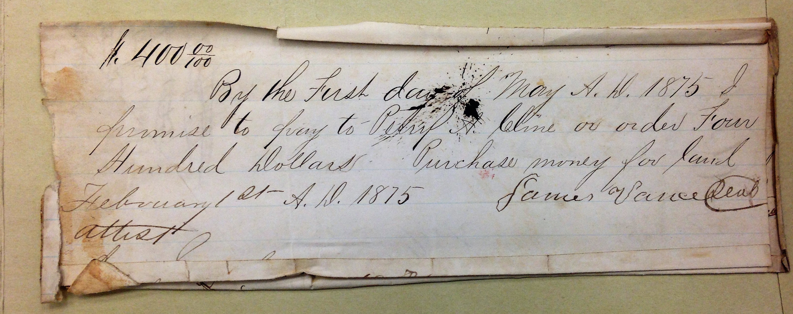
James Vance promissory note to Perry A. Cline, 1 February 1875.

Perry A. Cline petition, 8 May 1876.
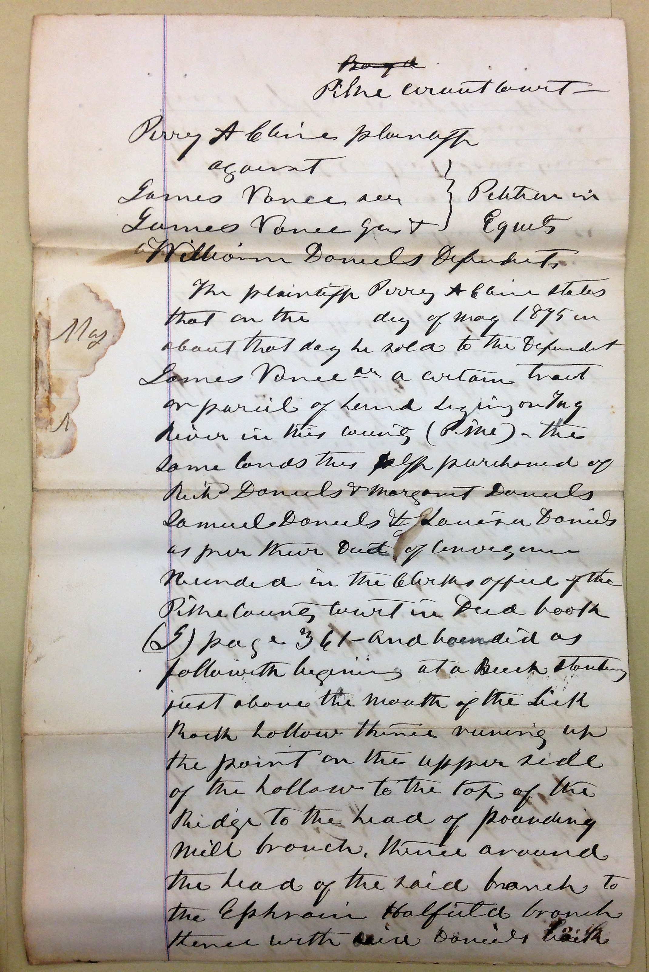
Perry A. Cline petition, 8 May 1876.
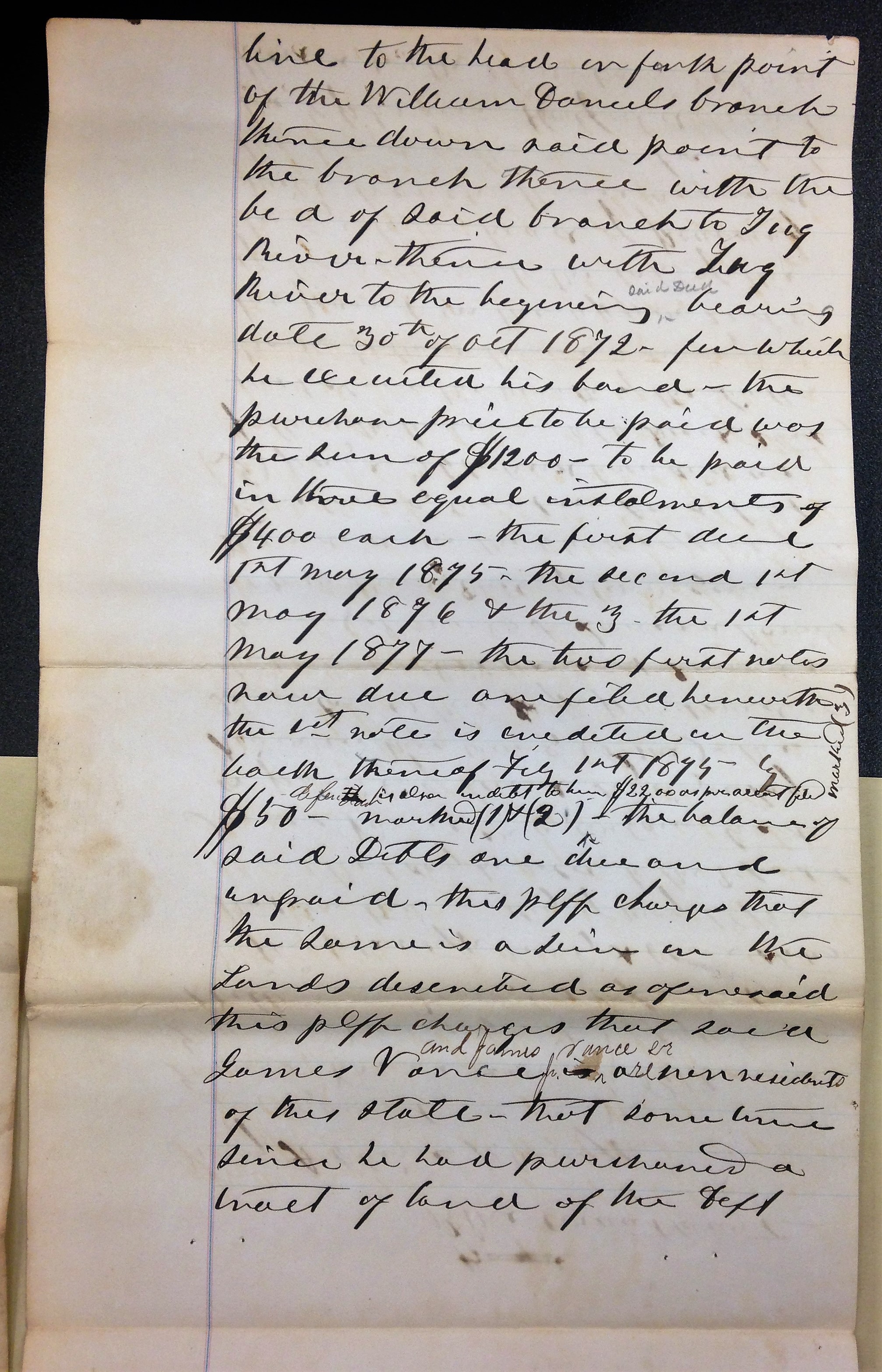
Perry A. Cline petition, 8 May 1876.

Perry A. Cline petition, 8 May 1876.
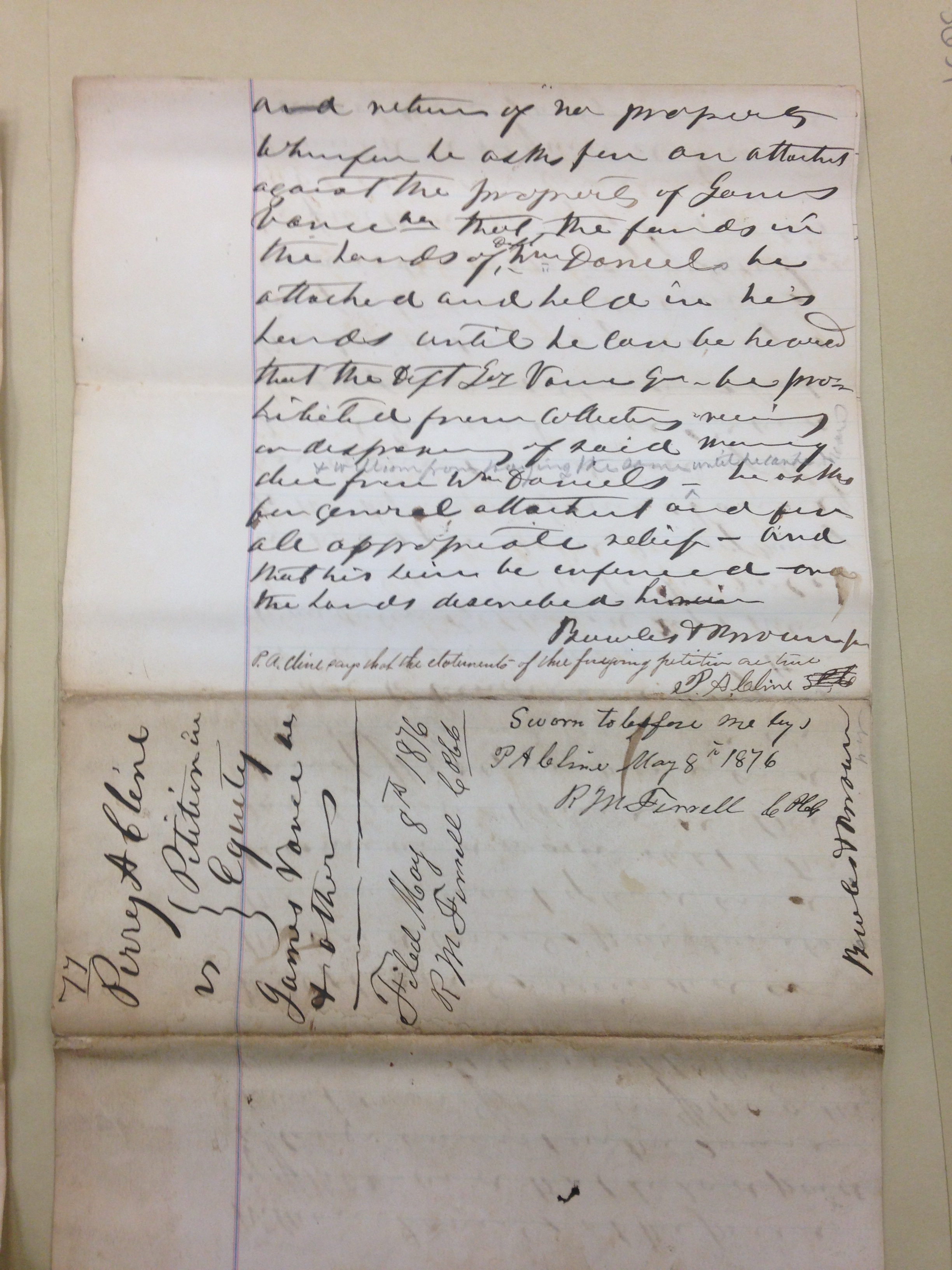
Perry A. Cline petition, 8 May 1876.

Perry A. Cline affidavit, 8 May 1876.
04 Wednesday Mar 2020
Posted in Hatfield-McCoy Feud
Tags
Ambrose Mullins, Appalachia, feud, feuds, Hatfield-McCoy Feud, history, Levisa Hatfield, Logan County, Mingo County, moonshine, moonshining, Vicy Hatfield, West Virginia

Levisa “Vicy” Hatfield indictment for selling spirituous liquors based upon information by Ambrose Mullins, Logan County, WV, 1882.
14 Tuesday Jan 2020
Posted in Big Sandy Valley, Hatfield-McCoy Feud, Pikeville
Tags
Appalachia, county clerk, crime, genealogy, Hatfield-McCoy Feud, history, Jacob Smith, James H. McCoy, John Dils, Kentucky, merchant, Pike County, Pleasant McCoy, Randolph McCoy, S.K. Damron, Sallie McCoy, Sam McCoy, sheriff, William McCoy, William P. Johnson

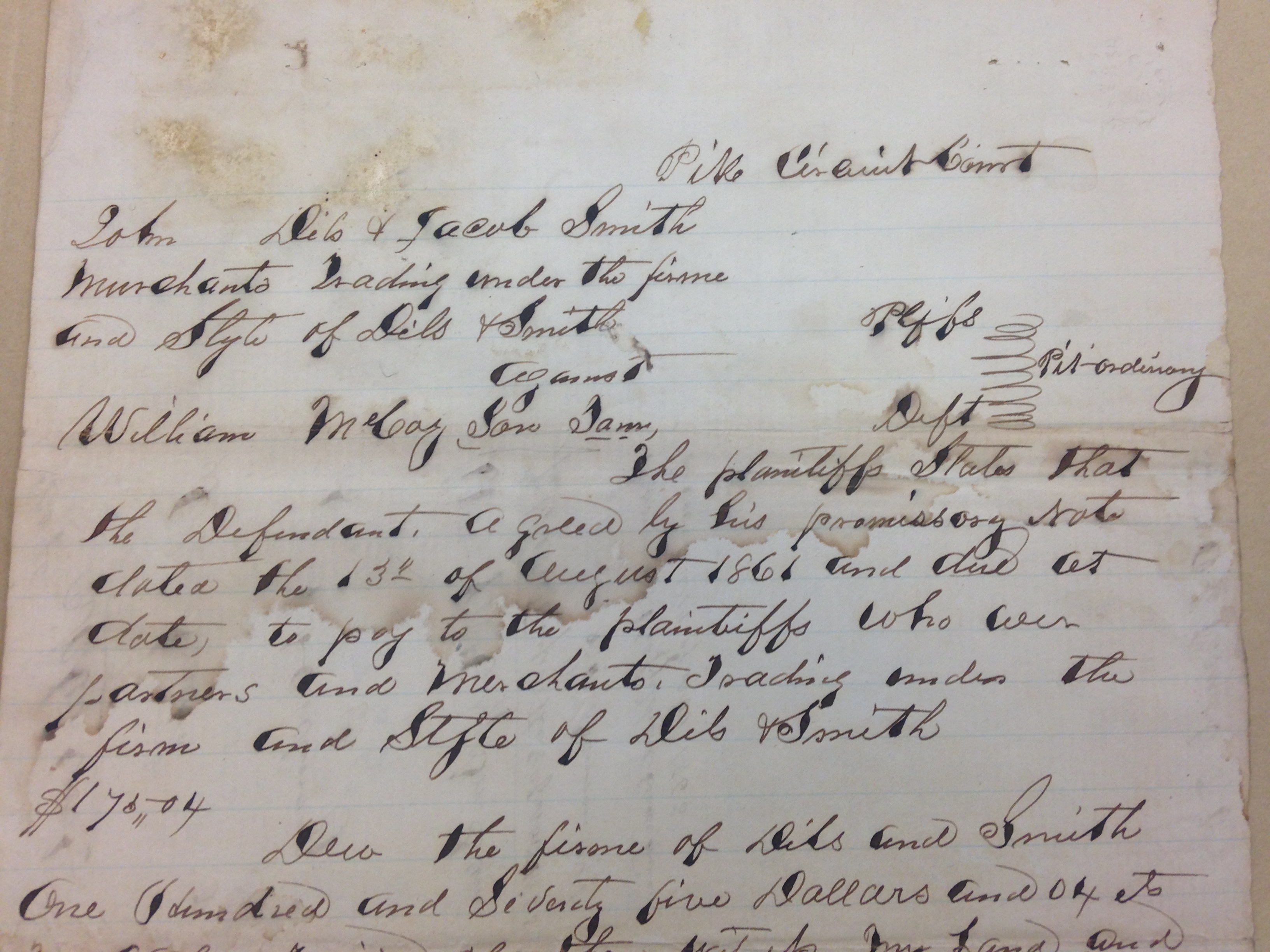
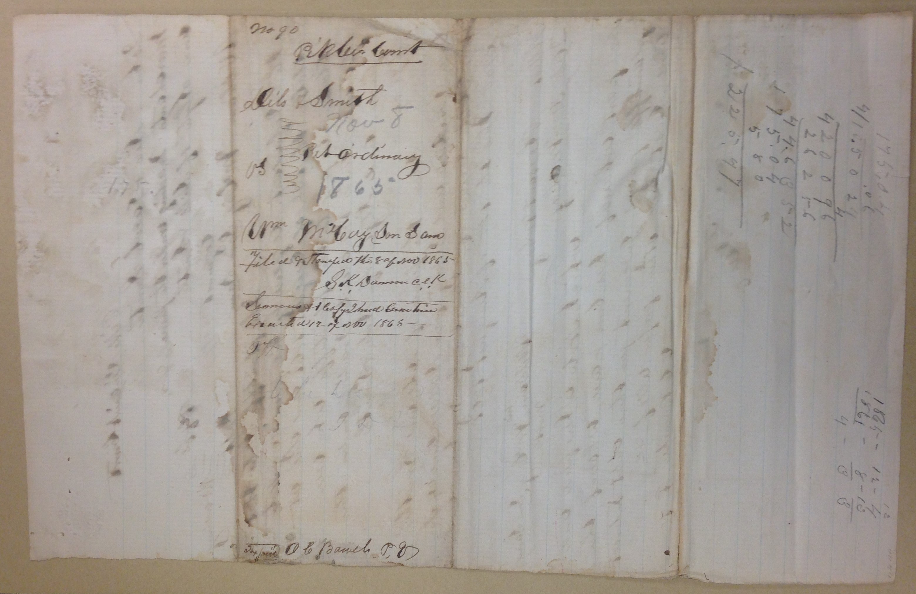
Promissory note between William McCoy and Dils and Smith (1861). Pike County, KY.

Page 1 (1865)
Page 1 (1865)

Page 1 (1865)

Page 1 (1865)
Page 1 (1865)

Summons for William McCoy (1865). Pike County, KY.

Summons for William McCoy (1865). Pike County, KY.
NOTE: This case is most definitely unrelated to the Hatfield-McCoy Feud. I included it here because of the involvement of John Dils. The William McCoy involved in the case is likely the brother to Sallie (McCoy) McCoy, wife of Randal McCoy.
Writings from my travels and experiences. High and fine literature is wine, and mine is only water; but everybody likes water. Mark Twain
This site is dedicated to the collection, preservation, and promotion of history and culture in Appalachia.
Genealogy and History in North Carolina and Beyond
A site about one of the most beautiful, interesting, tallented, outrageous and colorful personalities of the 20th Century